


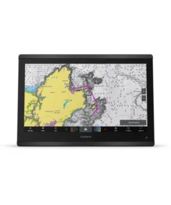
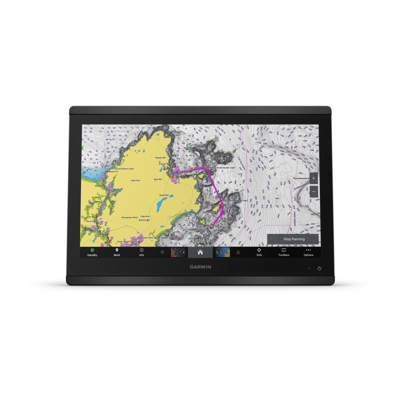
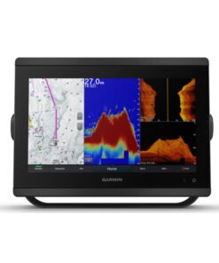
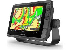
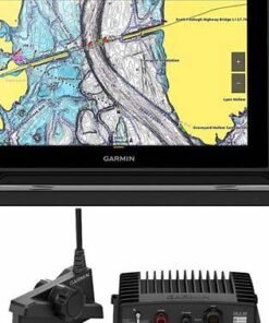
Garmin GPSMAP 8616xsv 16″ Chartplotter with Sonar and Garmin Navionics+ Mapping
€4,800.00

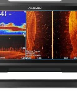
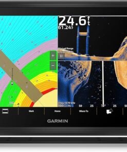
The Garmin® GPSMAP® 8616xsv 16″ Chartplotter with Sonar and Garmind Navionics+™ Mapping elevates your boating and your expectations. This Garmin multifunction display serves up a 16″ full HD touch-screen display with in-plane switching for wider viewing angles, superior clarity, and sunlight readability, even with polarized sunglasses. It offers built-in dual-channel 1kW traditional CHIRP, CHIRP ClearVü™ and CHIRP SideVü™ scanning sonars, and built-in support for Ultra High-Definition scanning sonar with no black box required. It also supports the LiveScope™ System and the entire live sonar product line, which allow you to clearly see fish swimming around and below your boat in real time (transducers not included). The Garmin 8616 MFD also comes preloaded with Garmin Navionics+ coastal charts and inland mapping with Auto Guidance+™ technology. Plus, there’s support for optional Garmin Navionics Vision+™ premium map content. Experience superior connectivity and networking solutions with complete control of your entire system right at your fingertips. The chartplotter includes a premium-performance processor for Garmin’s fastest map drawing, superior networking, video distribution, and more. Multiple displays can flat-mount edge-to-edge to create a sleek glass helm look or mounted flush. NMEA 2000® networking and the Garmin Marine Network let you build your full marine electronics suite, from radar and autopilots to cameras and instruments, all controlled from your chartplotter and shared across multiple screens. With SmartMode™ station controls, everything is designed to give you quick, 1-touch access to the information you need to ease high-stress situations such as docking. For full control of your boat on your chartplotter screen, use OneHelm™ to connect to many compatible third-party devices. Built-in Garmin SailAssist™ features provide data, displays, and prerace guidance to gain a competitive edge. Download the ActiveCaptain® app to your smartphone or tablet to manage your marine experience from anywhere, from trip planning and prefishing to purchasing, downloading, and updating maps. See RPMs, fuel flow, temperature, trim and more for up to four of your compatible Mercury® engines by using the SmartCraft® Connect gateway. The GPSMAP 8616 redefines possibilities on the water.
- 16″ full HD touch-screen display
- Wider viewing angles, superior clarity, and sunlight readability
- Built-in dual-channel 1kW traditional CHIRP sonar and CHIRP ClearVü™ and SideVü™ scanning sonars
- Built-in support for Ultra High-Definition scanning sonar with no black box required
- Compatible with LiveScope live sonar (transducer not included)
- Preloaded with Garmin Navionics+ coastal charts and inland mapping
- Auto Guidance+ technology
- Support for optional Garmin Navionics Vision+™ premium map content
- Premium-performance processor
- NMEA 2000 networking
- Garmin Marine Network
- SmartMode 1-touch access to information and controls
- OneHelm third-party device connectivity
- SailAssist sailing enhancements
- SmartCraft Connect gateway for Mercury engine data
Specifications
| Sonar Type | 2D/Down Scanning/Side Scanning |
| Screen Size | 16 inches |
| Transducer Model | None |
| GPS Included | Yes |
| Product Color | Black |
| Live Sonar Compatible | LiveScope Compatible |
| Map/Chart Type | US Freshwater/Saltwater |
| Model Number | 010-02093-51 |
| Pursuit | Saltwater Fishing |
Garmin GPSMAP 8616xsv 16″ Chartplotter with Sonar and Garmin Navionics+ Mapping – Premium Marine Navigation Reimagined
Confidence on the water has always been earned through clarity, precision, and trust. For that reason, the Garmin GPSMAP 8616xsv 16″ Chartplotter with Sonar and Garmin Navionics+ Mapping has been engineered to support boaters, anglers, and marine professionals who demand uncompromising performance. From coastal cruising to offshore fishing, every journey is enhanced through intelligent design and advanced marine technology.Garmin GPSMAP 8616xsv
At the center of this experience, innovation has been guided by decades of marine expertise from Garmin, ensuring that every feature is refined for real-world use. As a result, navigation accuracy is elevated, situational awareness is strengthened, and decision-making is simplified—no matter where the water leads.Garmin GPSMAP 8616xsv
A Commanding 16-Inch Display Designed for Total Situational Awareness
Visual clarity has been prioritized through a stunning 16-inch full HD touchscreen display. Because expansive screen real estate has been provided, charts, sonar returns, radar overlays, and vessel data are displayed simultaneously without clutter. As conditions change, critical information remains readable at a glance.
Moreover, sunlight readability has been enhanced to ensure consistent visibility during bright offshore days. Meanwhile, multi-touch functionality has been seamlessly integrated, allowing intuitive gestures to be used even while underway. Through this design approach, navigation control is maintained without distraction.
Display Advantages That Elevate Every Voyage
-
Large 16″ full HD touchscreen for immersive viewing
-
Edge-to-edge glass design for a modern helm aesthetic
-
Exceptional sunlight readability for offshore reliability
-
Responsive multi-touch controls for effortless operation
Because visual strain has been reduced, longer days on the water are supported with comfort and confidence.
Advanced Chartplotting Powered by Garmin Navionics+ Mapping
Navigation accuracy has been further refined through the inclusion of Garmin Navionics+ Mapping, which has been preloaded to deliver detailed coastal and inland charts. With this mapping solution, depth contours, navigational aids, marinas, and hazards are presented with exceptional clarity.
Additionally, regular chart updates are supported, ensuring that evolving waterways are reflected accurately. As a result, peace of mind is consistently reinforced through up-to-date information.
Mapping Capabilities That Support Smarter Navigation
-
High-resolution coastal and inland charts
-
Detailed depth contours and shallow-water shading
-
Integrated navigation aids and marina details
-
Ongoing chart update compatibility
Because route planning has been simplified, time on the water is spent navigating with assurance rather than uncertainty.
Integrated Sonar Technology for Precision Beneath the Surface
What lies beneath the vessel has been revealed with remarkable accuracy through integrated sonar support. With built-in compatibility for traditional CHIRP, ClearVü, and SideVü sonar (transducer dependent), underwater structures and fish targets are displayed with lifelike detail.
Furthermore, advanced signal processing has been applied to reduce noise and enhance target separation. As a result, fishing strategies are informed by clearer data, while underwater hazards are identified with greater confidence.
Sonar Features That Empower Every Angler
-
Traditional CHIRP sonar support for precise target separation
-
ClearVü and SideVü compatibility for photographic-like imaging
-
Enhanced bottom definition for structure identification
-
Reduced noise and interference for cleaner sonar views
Because underwater intelligence has been expanded, every cast and course correction is guided by actionable insight.Garmin GPSMAP 8616xsv
Garmin GPSMAP 8616xsv Seamless Networking for a Fully Integrated Helm
Modern vessels demand interconnected systems, and that expectation has been fully addressed. Through advanced networking capabilities, the Garmin GPSMAP 8616xsv has been designed to integrate seamlessly with radar, autopilot, engine data, cameras, audio systems, and additional displays.
Consequently, a centralized command station is created, allowing information to be shared across the helm effortlessly. Through Ethernet and NMEA connectivity, system expansion is supported without complexity.
Networking Benefits That Simplify Vessel Management
-
Full radar and autopilot integration
-
Engine and fuel data display compatibility
-
Multi-display synchronization across the helm
-
Camera and audio system connectivity
Because system harmony has been achieved, vessel control is transformed into a cohesive and intuitive experience.
Performance Engineered for Offshore Reliability
Reliability has been engineered into every component of the Garmin GPSMAP 8616xsv. Built to withstand harsh marine environments, the unit has been constructed with premium materials that resist corrosion, vibration, and temperature extremes.
In addition, fast processing power has been incorporated to ensure smooth transitions between charts, sonar views, and system data. As a result, lag has been minimized and real-time responsiveness has been preserved even during demanding conditions.
Garmin GPSMAP 8616xsv Durability and Performance Highlights
-
Marine-grade construction for long-term reliability
-
High-speed processor for smooth, responsive performance
-
Stable operation in rough conditions
-
Designed for professional and recreational use alike
Because durability has been prioritized, confidence is maintained season after season.
Garmin GPSMAP 8616xsv Inclusive Design That Supports Every Type of Boater
Ease of use has been intentionally emphasized so that both seasoned captains and newer boaters feel supported. Through customizable layouts and intuitive menus, information is presented in a way that aligns with individual preferences and experience levels.Garmin GPSMAP 8616xsv
Importantly, inclusive design principles have been applied to ensure accessibility across a wide range of users. Therefore, learning curves are reduced, and enjoyment on the water is increased for everyone on board.
Garmin GPSMAP 8616xsv Why the Garmin GPSMAP 8616xsv 16″ Chartplotter Stands Apart
Value has been created not only through features, but through the experience those features enable. By combining chartplotting, sonar, networking, and premium mapping into one cohesive system, an all-in-one marine navigation solution has been delivered.
Key Reasons This Chartplotter Is Chosen by Serious Boaters
-
Unmatched 16-inch display clarity
-
Advanced sonar integration
-
Garmin Navionics+ Mapping included
-
Robust networking and expansion options
-
Trusted Garmin marine engineering
Because every journey deserves precision and confidence, this chartplotter has been positioned as a long-term investment in safer, smarter navigation.


Advanced Sonar Intelligence That Transforms Underwater Awareness
Beneath every successful voyage, accurate underwater data has been relied upon to guide safe navigation and productive fishing. With the Garmin GPSMAP 8616xsv 16″ Chartplotter with Sonar and Garmin Navionics+ Mapping, sonar intelligence has been elevated into a strategic advantage rather than a basic feature.
Through advanced signal processing and refined imaging technologies, underwater environments are revealed with remarkable clarity. Consequently, submerged structures, fish targets, and bottom contours are interpreted with confidence instead of guesswork.Garmin GPSMAP 8616xsv
Traditional CHIRP Sonar for Precise Target Separation
Rather than relying on a single-frequency pulse, traditional CHIRP sonar has been employed to transmit a continuous range of frequencies. Because more data is returned, target separation is improved and noise is reduced across varying depths.
As a result, fish arches are displayed more distinctly, while bottom composition is identified with greater accuracy. Additionally, performance consistency is maintained whether shallow flats or deep offshore waters are being explored.
Garmin GPSMAP 8616xsv Benefits of CHIRP Sonar Integration
-
Enhanced target separation for clearer fish identification
-
Reduced surface clutter for cleaner sonar views
-
Improved depth performance across varied conditions
-
Reliable readings at cruising and trolling speeds
Because sonar accuracy has been strengthened, informed decisions are supported in real time.
Garmin GPSMAP 8616xsv ClearVü Sonar for Photographic-Like Downward Imaging
While traditional sonar offers valuable data, ClearVü sonar has been designed to provide a near-photographic view directly beneath the vessel. Through high-frequency scanning, structure, vegetation, and fish are displayed with exceptional detail.
Moreover, ambiguity has been minimized, allowing underwater features to be identified quickly. As a result, less time is spent interpreting sonar returns, and more time is devoted to strategic movement and casting.
ClearVü Advantages That Improve Fishing Efficiency
-
High-resolution downward imaging for detailed structure views
-
Improved clarity in shallow and mid-depth waters
-
Reduced interpretation learning curve
-
Enhanced identification of fish-holding areas
Because underwater visuals are simplified, confidence is reinforced with every pass.
SideVü Sonar for Expansive Lateral Coverage
In situations where wide-area scanning is required, SideVü sonar has been integrated to extend visibility far beyond the boat’s hull. By scanning to both sides simultaneously, underwater landscapes are mapped efficiently.
Consequently, schools of fish, drop-offs, and submerged objects are identified without repeated passes. Therefore, coverage efficiency is increased while fuel and time are conserved.
SideVü Capabilities That Expand Search Efficiency
-
Wide left-and-right scanning coverage
-
Identification of structure without driving directly overhead
-
Improved location of fish schools and ledges
-
Time-saving exploration of large areas
Because broader awareness has been delivered, search patterns are optimized with minimal effort.
Garmin GPSMAP 8616xsv Transducer Compatibility and Installation Flexibility
To support diverse vessel types and usage styles, extensive transducer compatibility has been provided. Whether through transom-mount, thru-hull, or in-hull installations, system customization is fully supported.
Additionally, professional-grade transducers are available to unlock maximum sonar performance. Because flexibility has been emphasized, the system adapts seamlessly to both recreational and commercial applications.
Garmin GPSMAP 8616xsv Supported Transducer Configurations
-
Transom-mount options for easy installation
-
Thru-hull transducers for high-performance sonar returns
-
In-hull compatibility for clean hull profiles
-
Professional-grade CHIRP transducers
Because installation adaptability has been prioritized, vessel-specific optimization is achieved without compromise.
Mapping Intelligence That Goes Beyond Basic Navigation
While sonar reveals what lies beneath, mapping intelligence defines where the vessel travels. With Garmin Navionics+ Mapping, navigational detail has been refined to support confident route planning and hazard avoidance.
Depth shading, contour detail, and navigational markers are layered intuitively, allowing critical information to be absorbed quickly. As a result, situational awareness is elevated across both familiar and unfamiliar waters.Garmin GPSMAP 8616xsv
Offshore Navigation Features Designed for Real-World Conditions
Offshore environments demand precision and reliability. For that reason, advanced navigation tools have been incorporated to support long-distance travel and challenging conditions.
From dynamic route planning to real-time position tracking, every reminder of location and direction has been clearly presented. Consequently, stress is reduced and focus is maintained on the journey ahead.
Offshore-Focused Navigation Tools
-
Dynamic route guidance with clear visual cues
-
Waypoint management for repeatable paths
-
Accurate GPS positioning for offshore confidence
-
Integration with radar and AIS systems
Because offshore navigation has been simplified, longer voyages are approached with assurance rather than hesitation.
Fishing Use Cases That Benefit from Advanced Sonar and Mapping
Fishing success has been influenced by preparation, information, and timing. Through the combined power of sonar and mapping, strategic advantages are consistently delivered.
Whether reef fishing, trolling offshore, or exploring inland waters, sonar views and chart data work together to guide productive decisions. Therefore, every fishing style is supported with tailored intelligence.
Fishing Scenarios Enhanced by the GPSMAP 8616xsv
-
Offshore trolling for pelagic species
-
Structure fishing around reefs and wrecks
-
Inshore flats and channel exploration
-
Freshwater lake and reservoir fishing
Because versatility has been engineered into the system, diverse fishing goals are supported without additional equipment.
Reliability That Supports Demanding Marine Environments
Performance consistency has been preserved through advanced processing power and stable system architecture. Even when multiple sonar views and overlays are displayed, responsiveness remains smooth and uninterrupted.
Furthermore, environmental resistance has been engineered to withstand saltwater exposure, vibration, and temperature variation. As a result, dependable operation is maintained throughout extended seasons on the water.
Why Sonar and Mapping Integration Matters
When sonar and mapping data are unified within a single interface, a deeper understanding of the marine environment is achieved. Instead of relying on isolated information sources, context is created through layered intelligence.
Therefore, navigation and fishing decisions are made with greater confidence, supported by real-time data that adapts to changing conditions.Garmin GPSMAP 8616xsv
Use-Case-Driven Performance Across Vessel Types and Boating Styles
Every vessel presents unique demands, and those demands have been carefully addressed through the flexible architecture of the Garmin GPSMAP 8616xsv 16″ Chartplotter with Sonar and Garmin Navionics+ Mapping. Rather than being limited to a single boating profile, this system has been designed to adapt fluidly across recreational, professional, and luxury marine environments.
Because real-world versatility has been prioritized, confident performance is delivered whether navigating coastal passages, managing offshore runs, or refining precision fishing strategies.
Center Console Boats: Precision, Speed, and Situational Control
For center console vessels, rapid decision-making and clear visibility have been essential. Through the expansive 16-inch display, sonar returns, charts, and radar overlays are presented without compromise.
Additionally, high-speed operation has been supported through fast GPS updates and stable tracking. As a result, navigation accuracy is preserved even during aggressive maneuvers and offshore transits.
Benefits for Center Console Owners
-
High-speed chart redraws for offshore runs
-
Split-screen sonar and navigation views
-
Clear readability in open, sun-exposed helms
-
Fast waypoint marking for active fishing
Because clarity has been sustained at speed, focus remains on performance rather than instrumentation.
Sportfishing Vessels: Intelligence That Improves Catch Efficiency
Fishing vessels demand more than navigation—they require intelligence. With advanced sonar integration and mapping detail, productive zones are identified efficiently, while unproductive water is bypassed.
Furthermore, repeatable success has been supported through waypoint management and track recording. Consequently, proven fishing locations are revisited with accuracy season after season.
Sportfishing Advantages Delivered
-
SideVü and ClearVü sonar coverage for structure detection
-
Waypoint marking of productive spots
-
Integrated radar support for offshore awareness
-
Multi-display expansion for cockpit and bridge views
Because fishing decisions are informed by data, time on the water is converted into measurable results.
Cruising Yachts: Comfort, Control, and Confidence at the Helm
For cruising yachts, ease of use and reliability have been emphasized. Through customizable dashboards, essential vessel information is displayed clearly without overwhelming the operator.
Moreover, seamless integration with autopilot, radar, and engine systems allows long-distance cruising to be managed with reduced fatigue. As a result, journeys are enjoyed with peace of mind rather than constant adjustment.
Yacht-Focused Navigation Enhancements
-
Autopilot integration for hands-off cruising
-
Engine and fuel monitoring support
-
Large, easy-to-read charts for relaxed navigation
-
Centralized helm control
Because comfort has been designed into the interface, longer passages feel more intuitive and less demanding.
Multi-Display Helm Layouts for Scalable Command Centers
As vessel systems grow, scalable display solutions become essential. The Garmin GPSMAP 8616xsv has been engineered to support multi-display helms through synchronized networking.
Charts, sonar, and system data are shared instantly across displays, ensuring consistency regardless of viewing position. Therefore, situational awareness is maintained across the entire helm environment.
Multi-Display Networking Capabilities
-
Ethernet-based display synchronization
-
Shared sonar and chart data
-
Flexible layout customization per screen
-
Seamless expansion as vessel needs evolve
Because scalability has been embedded into the system, long-term upgrades are supported without replacement.
GPSMAP 8600 Series Comparison and Positioning
Within the GPSMAP 8600 series, the 8616xsv model has been positioned as a premium balance of size, performance, and capability. While smaller models offer portability, the 16-inch variant delivers maximum visibility and control.
Additionally, processing power and networking features have been aligned with professional-grade expectations. As a result, the 8616xsv stands as a flagship option for serious mariners.
Why the 8616xsv Is Often Preferred
-
Largest display option in the series
-
Built-in sonar support
-
Advanced networking and expansion
-
Ideal balance between size and helm integration
Because long-term value has been considered, this model supports both current and future navigation needs.
System Expansion for Radar, AIS, and Marine Sensors
Beyond chartplotting and sonar, comprehensive marine awareness has been enabled through system expansion. Radar overlays, AIS target tracking, and camera feeds are seamlessly integrated into the display environment.
Consequently, collision avoidance and situational monitoring are strengthened, particularly in congested waterways or low-visibility conditions.
Expansion Options That Enhance Safety
-
Radar integration for weather and traffic awareness
-
AIS support for vessel tracking
-
Camera connectivity for docking assistance
-
Environmental sensor data display
Because layered awareness has been achieved, safer navigation decisions are consistently supported.
Inclusive Design That Reduces Learning Curves
Marine electronics should empower rather than intimidate. For that reason, interface design has been refined to support both experienced captains and newer operators.salt water fishing poles
Customizable layouts, intuitive menus, and logical workflows ensure that essential functions are accessed quickly. Therefore, confidence is built through usability rather than complexity.
Trust, Longevity, and Investment Value
Purchasing marine electronics represents a long-term investment. With Garmin engineering and ongoing software support, longevity has been built into the GPSMAP 8616xsv platform.
Updates, compatibility, and expandability ensure relevance as technology evolves. As a result, value is preserved far beyond the initial installation.
Why Vessel-Specific Optimization Matters
When electronics align with vessel type and usage style, performance improves naturally. Instead of adapting habits to equipment limitations, the system adapts to the operator’s needs.
Frequently Asked Questions – Garmin GPSMAP 8616xsv 16″ Chartplotter with Sonar and Garmin Navionics+ Mapping
Clarity before purchase has been recognized as essential for confident decision-making. For that reason, the most common questions about the Garmin GPSMAP 8616xsv 16″ Chartplotter with Sonar and Garmin Navionics+ Mapping have been addressed below in a clear, inclusive, and buyer-focused format.
What makes the Garmin GPSMAP 8616xsv different from other chartplotters?
Rather than functioning as a basic navigation screen, the GPSMAP 8616xsv has been engineered as a fully integrated marine command center. Chartplotting, sonar, networking, and premium mapping have been unified into one platform.
As a result, situational awareness is improved, system clutter is reduced, and long-term scalability is supported through professional-grade design from Garmin.
Is Garmin Navionics+ Mapping included or sold separately?
Garmin Navionics+ Mapping has been included with the unit. High-resolution coastal and inland charts are preloaded, providing immediate access to detailed depth contours, navigational aids, and marina information.
Additionally, chart update compatibility has been supported, ensuring that mapping data remains accurate as waterways evolve.
Does the GPSMAP 8616xsv include a transducer?
A transducer is not always included by default. However, extensive compatibility with Garmin transducers has been provided, allowing the system to be customized based on vessel type and sonar needs.
Because flexibility has been prioritized, transom-mount, thru-hull, and in-hull transducer options are fully supported.
What sonar types are supported by this chartplotter?
Advanced sonar support has been built into the GPSMAP 8616xsv. Traditional CHIRP, ClearVü, and SideVü sonar capabilities are supported when paired with compatible transducers.
Therefore, underwater detail is delivered with clarity, whether identifying fish targets, bottom structure, or wide-area features.
Can this chartplotter be networked with other Garmin marine equipment?
Yes, full networking capability has been provided. Radar, autopilot systems, engine data, AIS, cameras, audio systems, and additional displays can all be integrated.
Through Ethernet and NMEA connectivity, a centralized helm experience is created, allowing data to be shared seamlessly across the vessel.Chartplotter with Sonar
Is the 16-inch display too large for smaller boats?
Although the 16-inch display offers expansive visibility, it has been designed with flexible installation options. For many center console and mid-size vessels, the screen enhances usability without overwhelming the helm.
Because layout customization has been included, information density can be adjusted to suit both compact and spacious helms.
Chartplotter with Sonar
How readable is the screen in direct sunlight?
Sunlight readability has been specifically engineered into the display. High-brightness output and anti-glare glass ensure that charts and sonar data remain visible even during bright offshore conditions.
As a result, eye strain is reduced and safety is improved during daytime operation.
Is the GPSMAP 8616xsv suitable for offshore boating?
Offshore performance has been a core design focus. Accurate GPS positioning, advanced mapping, radar integration, and stable operation in rough conditions have all been incorporated.
Consequently, longer offshore runs are supported with confidence and precision.
Can the interface be customized for different users?
Yes, extensive customization options have been provided. Layouts, split screens, data overlays, and dashboards can be configured to match individual preferences and experience levels.
Because inclusive design principles have been applied, both experienced captains and newer boaters are supported with intuitive controls.
Does this chartplotter support future upgrades?
Long-term relevance has been prioritized through software updates, system expansion, and compatibility with evolving Garmin marine technology.
Therefore, the GPSMAP 8616xsv is positioned as a future-ready investment rather than a short-term solution.
Is professional installation recommended?
While experienced users may choose self-installation, professional installation has been recommended for optimal networking, transducer placement, and system integration.
Because correct setup influences performance, professional installation often ensures the best long-term results.
Who is this chartplotter best suited for?
The Garmin GPSMAP 8616xsv has been designed for:
-
Offshore and coastal boaters
-
Sportfishing enthusiasts
-
Cruising yacht owners
-
Marine professionals seeking reliability
Because versatility has been engineered into the platform, a wide range of boating styles and skill levels are supported.
| Sonar Type: | 2D-Down Scanning-Side Scanning |
|---|---|
| Color: | Black |
| GPS Included: | Yes |
| Transducer Model: | None |
| Screen Size: | 16 inches |
Be the first to review “Garmin GPSMAP 8616xsv 16″ Chartplotter with Sonar and Garmin Navionics+ Mapping”
Related products
Fish Finder & Navigation
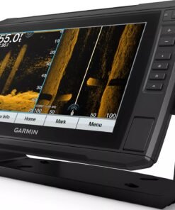
Garmin GPSMAP Touch Screen Fish Finder/Chart Plotter Combo with Mapping and Sonar
Fish Finder & Navigation
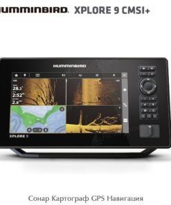
Humminbird XPLORE 9 CMSI+ CHIRP MEGA SI Fish Finder/Chartplotter
Fish Finder & Navigation
Fish Finder & Navigation
Garmin ECHOMAP Ultra 2 106sv Fish Finder/Chartplotter with Navionics+
Fish Finder & Navigation
Fish Finder & Navigation
Lowrance Elite FS 12 Fish Finder/Chartplotter with TotalScan Transducer
Fish Finder & Navigation
Fish Finder & Navigation
Garmin ECHOMAP UHD2 93SV GT54 Transducer with LiveScope Plus LVS34 Bundle
Reviews
There are no reviews yet.