


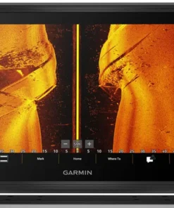
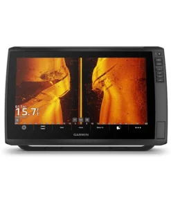
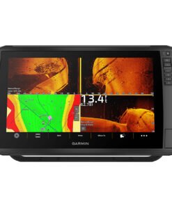
Garmin ECHOMAP Ultra 2 166sv 16″ Fish Finder/Chartplotter with Navionics+
€3,400.00

Designed with the serious angler in mind, the Garmin® ECHOMAP™ Ultra 2 166sv 16″ Fish Finder/Chartplotter with Navionics+ brings the ultimate in big-picture clarity, brightness, and readability to your navigation mapping and sonar returns. Plus, there’s support for the full line of LiveScope™ sonars, Ultra High-Definition ClearVü™ and SideVü® scanning sonars photo-like images of what’s beneath the surface, as well as CHIRP traditional sonar (transducers not included). Built-in Garmin Navionics+ mapping gives you detailed mapping data, depth range shading, and more, with a 1-year subscription for daily updates. The integrated HDMI output connector lets you share your sonar screen with a TV or other external display. Built-in Bluetooth® wireless connectivity enables you to give voice commands to your chartplotter for hands-free control of such features as Force® trolling motor modes, favorite keys, sonar inputs, and more. Vivid, high-contrast scanning-sonar color palettes make it easier than ever to distinguish targets and structure. Wireless networking lets you share sonar, waypoints and routes with another ECHOMAP Ultra 2 or UHD2 plotter on board. Multi-band GPS provides incredible position accuracy. NMEA® 2000® network compatibility gives you connectivity to heading sensors, autopilots, Fusion-Link™ audio systems, and more. Pair with the free ActiveCaptain® smart-device app for software updates, screen recording, Garmin Quickdraw® Community, data and more. Wirelessly connect to your Force trolling motor (not included) to navigate to waypoints, draw and follow routes, and more. Use the screen-recording feature through the ActiveCaptain® app on your smartphone to share images from your chartplotter. Surface-mount your compatible ECHOMAP Ultra 2 chartplotter by using the bail mount with knobs; the mount tilts for optimum viewing. It’s the high-powered sonar upgrade to step your boating and angling forever.
- Incredibly crisp, hi-res, sunlight-readable 16″ display
- Support LiveScope sonars, Ultra High-Definition ClearVü and SideVü scanning sonars, and CHIRP traditional sonar (transducers not included)
- Built-in Garmin Navionics+ mapping: detailed mapping data, depth range shading, and more, with a 1-year subscription for daily updates
- Integrated HDMI output
- Built-in Bluetooth wireless connectivity: voice commands to your chartplotter for hands-free control
- Vivid, high-contrast scanning-sonar color palettes
- Wireless networking to share sonar, waypoints, and routes with another onboard ECHOMAP Ultra 2 or UHD2 chartplotter
- Multi-band GPS for pinpoint position accuracy
- NMEA 2000 connectivity to heading sensors, autopilots, Fusion-Link audio systems, and more
- Free ActiveCaptain smart-device app for software updates, screen recording, Garmin Quickdraw Community data, and more
- Wirelessly connect to your Force trolling motor (not included) to navigate to waypoints, draw and follow routes, and more
- Screen-recording feature through ActiveCaptain app to share images from chartplotter
Specifications
| GPS Included | Yes |
| Model Number | 010-03386-00 |
| Pursuit | Freshwater Fishing |
| Water Resistance | IPX7 |
Garmin ECHOMAP Ultra 2 166sv 16″ Fish Finder/Chartplotter with Navionics+
Precision Marine Navigation Reimagined for Serious Anglers
Advanced marine electronics have been redefined with the Garmin ECHOMAP Ultra 2 166sv 16″ Fish Finder/Chartplotter with Navionics+, where professional-grade sonar intelligence is delivered through an expansive ultra-high-definition touchscreen. Built for anglers who demand clarity, control, and confidence, every on-water decision is supported by data that has been refined, visualized, and optimized.
Rather than relying on guesswork, fish behavior is revealed with stunning realism. Instead of switching between multiple devices, seamless integration is experienced in a single powerhouse display. As a result, efficiency is increased, accuracy is enhanced, and time on productive water is maximized.
Why the Garmin ECHOMAP Ultra 2 166sv Stands Apart
Engineered for Visibility, Control, and Confidence
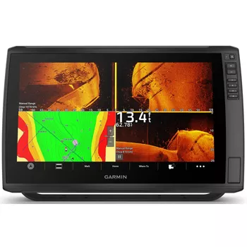
A 16-inch ultra-bright touchscreen has been incorporated to ensure visibility in direct sunlight and low-light conditions alike. Through this expansive display, sonar returns, charts, and navigation data are presented with remarkable sharpness. Consequently, situational awareness is improved without visual strain.
Unlike conventional fish finders, multi-touch gestures are supported, allowing zooming, panning, and waypoint marking to be performed intuitively. Therefore, operation is simplified even during demanding conditions.
Ultra-High-Definition Sonar Performance
See Structure, Fish, and Bottom Detail Like Never Before
Premium sonar technology has been integrated to deliver exceptional underwater clarity. By utilizing Garmin’s most advanced scanning capabilities, underwater environments are interpreted with photographic-style detail.
Garmin ECHOMAP Ultra 2 166sv Included sonar capabilities:
-
Ultra High-Definition ClearVü™
-
Ultra High-Definition SideVü™
-
Traditional CHIRP sonar support
As a result, fish separation is improved, bottom contours are defined more clearly, and structure edges are revealed with unprecedented precision. Additionally, subtle movements and suspended targets are detected with ease.Garmin ECHOMAP Ultra 2 166sv
Built-In Navionics+ Mapping for Superior Charting
Navigate Confidently with Preloaded Coastal and Inland Maps
With Navionics+ charts preloaded, navigation is simplified from the moment the unit is powered on. Coverage includes coastal waters, lakes, rivers, and reservoirs, ensuring widespread usability.
Furthermore, charts are enhanced with:
-
Depth contours as precise as 1 foot
-
Clearly defined channels and hazards
-
Shoreline detail optimized for fishing strategy
Because regular updates are supported, chart accuracy is continuously improved. Consequently, confidence is maintained even when exploring unfamiliar waters.
Seamless Network Integration
Expand Your System Without Complexity
Wireless connectivity has been engineered into the unit, allowing effortless sharing of sonar, waypoints, and routes with compatible Garmin devices. As a result, a cohesive onboard network is established without additional wiring.
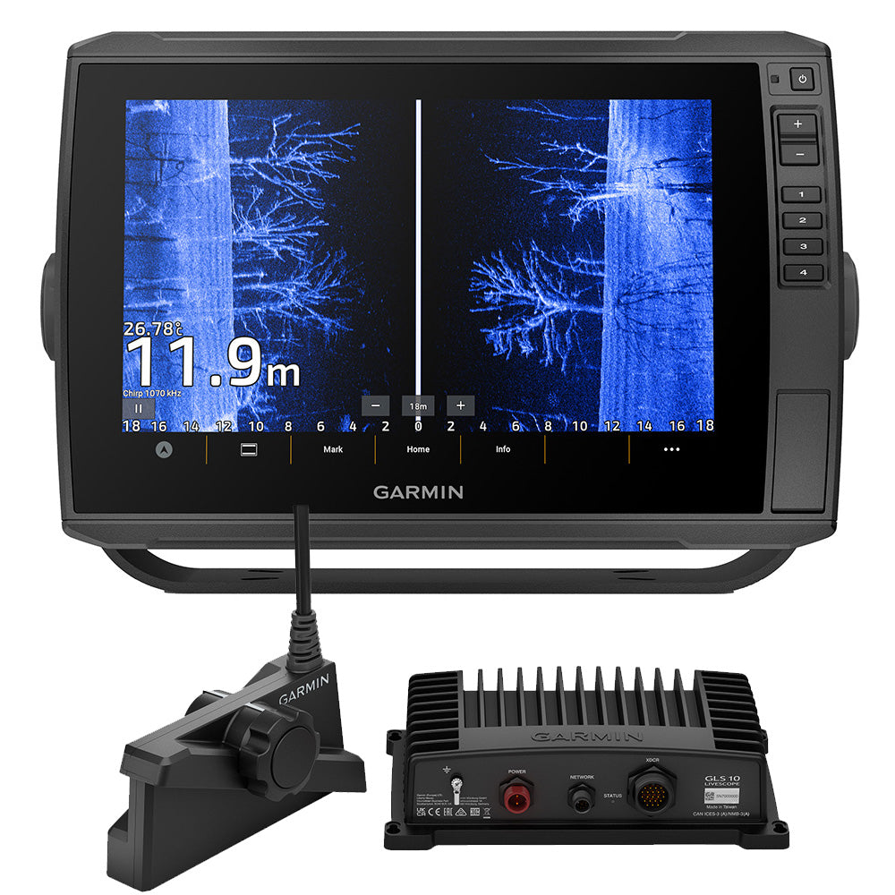
Moreover, compatibility with Garmin LiveScope™ systems allows real-time sonar imagery to be displayed, enabling fish movement to be observed as it happens.
Designed for Real-World Fishing Conditions
Built Tough for Demanding Marine Environments
Durability has been prioritized through rugged construction and marine-grade materials. The touchscreen has been reinforced for long-term reliability, while the housing has been sealed to withstand spray, vibration, and temperature changes.Garmin ECHOMAP Ultra 2 166sv
Therefore, performance is preserved whether the unit is mounted on a bass boat, offshore vessel, or multi-species fishing platform.Garmin ECHOMAP Ultra 2 166sv
Highlighted Product Specifications
-
16″ Ultra-High-Resolution Touchscreen Display
-
Ultra High-Definition ClearVü™ and SideVü™ Sonar
-
Traditional CHIRP Sonar Support
-
Preloaded Navionics+ Charts
-
Wireless Network Sharing
-
LiveScope™ Compatibility
-
Fast, Responsive User Interface
-
Rugged Marine-Grade Construction
Each feature has been carefully integrated to support accuracy, efficiency, and user confidence.
Optimized for Both Freshwater and Saltwater Anglers
One System, Endless Possibilities
Whether targeting bass in inland lakes or pursuing pelagic species offshore, adaptability has been built into the system. Sonar frequencies, chart views, and data overlays can be customized to suit individual fishing styles.
As a result, inclusivity is reinforced—beginners, experienced anglers, and professionals alike are supported without compromise.
Conversion-Focused Advantage
Invest Once, Upgrade Your Entire Fishing Experience
Instead of purchasing separate sonar and navigation devices, value is delivered through an all-in-one solution. Time spent adjusting equipment is reduced, while time spent fishing productively is increased.
Ultimately, confidence is built through clarity. Success is supported through technology. And satisfaction is achieved through reliability.


Advanced Sonar Technology That Transforms How Fish Are Found
Underwater Intelligence Delivered in Real Time
Underwater exploration has been elevated through the sonar architecture embedded within the Garmin ECHOMAP Ultra 2 166sv 16″ Fish Finder/Chartplotter with Navionics+. Instead of abstract marks and ambiguous returns, lifelike underwater scenes are presented with clarity that supports faster, smarter fishing decisions.
Because multiple sonar technologies are supported simultaneously, interpretation is simplified while confidence is increased. As a result, more informed choices are made with less hesitation.Garmin ECHOMAP Ultra 2 166sv
Garmin ECHOMAP Ultra 2 166sv Ultra High-Definition ClearVü™ Sonar
Structure and Bottom Detail Revealed with Precision
Through Ultra High-Definition ClearVü™ sonar, near-photographic views of what lies directly beneath the vessel are generated. Rather than relying on traditional cone-shaped sonar alone, a razor-thin scanning beam is used to render structure edges, drop-offs, and fish-holding cover with remarkable definition.
Consequently, submerged timber, rock piles, ledges, and vegetation are distinguished clearly from fish targets. Furthermore, bait presence is identified more easily, allowing productive areas to be prioritized efficiently.
ClearVü™ advantages include:
-
Crisp bottom contour separation
-
Improved fish-to-structure distinction
-
Enhanced clarity in shallow and deep water
-
Reduced noise and signal clutter
Because detail is preserved even at speed, scouting time is reduced and fishing time is maximized.
Ultra High-Definition SideVü™ Sonar
Expand Your Search Area Without Extra Passes
Lateral scanning capability has been refined through Ultra High-Definition SideVü™ sonar, allowing expansive underwater coverage on both sides of the boat. Instead of repeatedly crossing the same water, large areas are scanned in a single pass.
As a result, fish-holding structure is identified faster, schools are located sooner, and patterns are established with less effort.
Additionally, long-range clarity ensures that targets remain sharp even at extended distances. Therefore, efficiency is improved during both search and precision fishing phases.
SideVü™ benefits include:
-
Wide-area underwater scanning
-
High-resolution imaging at distance
-
Clear identification of fish shadows
-
Faster elimination of unproductive water
Traditional CHIRP Sonar Support
Proven Technology Enhanced Through Processing Power
While scanning sonar delivers visual realism, traditional CHIRP sonar remains essential for precise depth tracking and fish arch interpretation. Through continuous frequency modulation, stronger target separation is achieved across varying depths.
Accordingly, individual fish are distinguished more effectively from schools, thermoclines, and bottom returns. Because signal clarity is maintained, performance remains reliable even in challenging water conditions.
Navigation Mastery Built for Confident On-Water Decisions
Position Awareness Enhanced Through Intelligent Charting
Navigation accuracy has been elevated through the integration of advanced GPS technology and preloaded Navionics+ charts within the Garmin ECHOMAP Ultra 2 166sv 16″ Fish Finder/Chartplotter with Navionics+. Instead of navigating with approximations, precise vessel positioning is delivered consistently.
As a result, confidence is reinforced during exploration, travel efficiency is improved, and navigational errors are reduced significantly. Moreover, situational awareness is maintained even when environmental conditions change rapidly.Garmin ECHOMAP Ultra 2 166sv
Preloaded Navionics+ Charts Explained
Detailed Mapping That Supports Smarter Fishing Strategy
High-definition cartography has been included to ensure clarity across inland and coastal waters. Through Navionics+, depth contours, shoreline details, and underwater structure are rendered with exceptional precision.
Consequently, fishing strategy is informed by visual intelligence rather than assumption. Additionally, productive zones are identified more quickly, allowing time to be spent where it matters most.Garmin ECHOMAP Ultra 2 166sv
Navionics+ mapping highlights include:
-
1-foot depth contour detail
-
Clearly marked channels and hazards
-
Comprehensive inland and coastal coverage
-
Frequent chart update compatibility
Because accuracy is prioritized, exploration is encouraged without unnecessary risk.
Depth Contours That Reveal Fish-Holding Structure
Visualizing the Underwater Landscape
Subtle depth changes often determine fish location. For that reason, high-resolution contour mapping plays a critical role in fishing success. With Navionics+ depth intelligence, ledges, drop-offs, humps, and channels are displayed clearly.
Accordingly, ambush points and transition zones are identified faster. Furthermore, seasonal patterns are analyzed more effectively when bottom composition is visible at a glance.
Waypoint Management Designed for Efficiency
Mark, Organize, and Return with Precision
Waypoint creation has been streamlined to ensure important locations are never lost. Through intuitive touchscreen controls, waypoints are dropped instantly while navigating or fishing.
As a result, productive spots are preserved, travel routes are optimized, and return trips are executed with confidence.
Waypoint functionality includes:
-
Instant waypoint marking
-
Custom icons and labels
-
Easy sorting and filtering
-
Wireless sharing between compatible units
Because organization is simplified, more time is spent fishing and less time is spent managing data.
Route Planning That Saves Time and Fuel
Navigate Smarter, Not Harder
Efficient route creation has been built into the navigation interface. Instead of relying on memory or guesswork, safe and optimized paths are planned directly on the chartplotter.
Therefore, fuel consumption is reduced, hazards are avoided, and arrival times are improved. Additionally, routes can be adjusted dynamically as conditions evolve.
GPS Accuracy You Can Rely On
Consistent Positioning in All Conditions
High-sensitivity GPS performance ensures vessel location remains accurate even in challenging environments. Because satellite data is processed rapidly, position updates are delivered smoothly and reliably.
Consequently, waypoint accuracy is preserved, track logs remain precise, and confidence is maintained during both short runs and long journeys.
Garmin ECHOMAP Ultra 2 166sv Track Recording for Pattern Analysis
Learn from Every Trip on the Water
Automatic track recording allows movement history to be reviewed and analyzed. Through this feature, successful passes, trolling paths, and productive drifts are documented without manual input.ocean fishing rods
As a result, patterns are identified over time, repeatable success is supported, and strategic adjustments are made with clarity.Garmin ECHOMAP Ultra 2 166sv
Garmin ECHOMAP Ultra 2 166sv Chart Customization for Individual Preferences
Control the Information That Matters Most
Chart views can be customized to match personal navigation and fishing styles. Data overlays, depth shading, and color palettes are adjusted effortlessly through the touchscreen interface.
Therefore, visual clarity is improved, decision-making is accelerated, and distractions are minimized.
Integrated Navigation and Sonar Views
One Screen, Complete Awareness
Split-screen functionality allows sonar data and navigation charts to be displayed simultaneously. Instead of switching between modes, real-time awareness is maintained across both underwater and surface environments.
As a result, adjustments are made proactively rather than reactively, improving efficiency during active fishing sessions.
Safety-Focused Navigation Features
Confidence Beyond Fishing Performance
Navigation tools have been designed not only for fishing success but also for safety. Marked hazards, shallow water indicators, and precise route guidance contribute to safer operation in unfamiliar waters.
Because awareness is enhanced, risk is reduced and confidence is strengthened throughout every trip.
Navigation Feature Summary
Highlighted Chartplotter Capabilities
-
Preloaded Navionics+ Charts
-
High-Sensitivity GPS Receiver
-
1-Foot Depth Contour Mapping
-
Advanced Waypoint Management
-
Route Planning and Tracking
-
Split-Screen Chart and Sonar Views
-
Customizable Chart Display Options
-
Wireless Data Sharing
Each navigation feature has been engineered to support smarter decisions, smoother travel, and more productive fishing outcomes.
Why Advanced Navigation Converts Exploration into Success
Clarity That Builds Confidence on Every Trip
Instead of navigating reactively, anglers are empowered to plan, execute, and refine their approach with confidence. Water is covered efficiently. Hazards are avoided proactively. And productive zones are revisited with precision.
Ultimately, success on the water is supported through navigation intelligence that works quietly, accurately, and consistently in the background.
LiveScope™ Compatibility for Real-Time Fishing
Watch Fish Move, React, and Strike
Real-time sonar support has been enabled through compatibility with Garmin LiveScope™ systems. Rather than reviewing historical sonar data, live underwater movement is displayed as it happens.
Thus, fish behavior is observed in real time. Lure presentation is adjusted instantly. And strike opportunities are capitalized on with precision.
When paired with LiveScope™, the Garmin ECHOMAP Ultra 2 166sv 16″ Fish Finder/Chartplotter with Navionics+ becomes a forward-looking fishing intelligence system rather than a reactive tool.
LiveScope™ advantages include:
-
Real-time fish movement visualization
-
Immediate lure tracking
-
Faster reaction to fish behavior
-
Higher hook-up efficiency
Sonar Customization for Every Fishing Style
Control the Data You See—How You Want to See It
Advanced customization options have been built into the interface, allowing sonar views to be tailored to personal preference and fishing conditions. Sensitivity, color palettes, depth ranges, and overlays are adjusted easily through the touchscreen.
As a result, visual fatigue is reduced while clarity is enhanced. Moreover, different sonar views can be displayed simultaneously, allowing scanning and targeting to occur without switching screens.
Intelligent Target Separation for Better Decisions
Less Guessing, More Confidence
Through Garmin’s advanced signal processing, clutter is minimized and relevant targets are emphasized. Because noise reduction algorithms are continuously applied, clearer returns are delivered even in turbulent or debris-filled water.
Therefore, fish identification becomes more reliable, misinterpretation is reduced, and confidence in sonar readings is strengthened.
Performance Across Depths and Conditions
Reliable Results in Shallow, Mid, and Deep Water
Whether fishing shallow flats, mid-depth ledges, or deep offshore structure, sonar performance remains consistent. Because frequency management is optimized automatically, transitions between depths occur smoothly.
Additionally, clarity is preserved during high-speed movement, making the unit equally effective for scouting and precision fishing.
Key Sonar Capabilities Summary
Highlighted Sonar Feature List
-
Ultra High-Definition ClearVü™ Sonar
-
Ultra High-Definition SideVü™ Sonar
-
Traditional CHIRP Sonar
-
LiveScope™ System Compatibility
-
Advanced Noise Reduction
-
Customizable Sonar Views
-
Real-Time Data Processing
-
High-Speed Clarity Retention
Each capability has been engineered to work together, ensuring underwater intelligence is delivered without compromise.
Why This Sonar System Converts More Fish into Catches
Technology That Actively Supports Results
Rather than simply displaying data, the sonar system actively supports smarter decisions. Patterns are recognized sooner. Productive zones are isolated faster. And wasted time is minimized consistently.
Ultimately, fishing success is no longer dependent on instinct alone. Instead, it is reinforced through real-time visual intelligence that adapts as conditions change.
Frequently Asked Questions (FAQs)
Everything Buyers Want to Know—Answered Clearly
What makes the Garmin ECHOMAP Ultra 2 166sv different from previous ECHOMAP models?
A significant upgrade has been delivered through enhanced processing power, an expanded 16-inch ultra-high-definition touchscreen, and improved sonar clarity. Compared to earlier generations, faster response times, sharper imaging, and smoother multitasking are experienced consistently.
As a result, navigation accuracy is improved, sonar interpretation is simplified, and overall efficiency on the water is increased.
Is the Garmin ECHOMAP Ultra 2 166sv suitable for both freshwater and saltwater fishing?
Yes. The unit has been engineered for reliable performance in both freshwater and saltwater environments. Marine-grade materials and sealed construction ensure durability under varying conditions.
Therefore, versatility is supported whether inland lakes, rivers, or coastal waters are being explored.
Does this fish finder come with maps preloaded?
Yes. Navionics+ charts are preloaded, providing detailed inland and coastal mapping immediately after installation. Depth contours, navigational aids, and shoreline data are included.
Additionally, compatibility with regular chart updates ensures long-term accuracy and relevance.
Can LiveScope™ sonar be used with this chartplotter?
Yes. Full compatibility with Garmin LiveScope™ systems has been enabled. Real-time sonar views can be displayed directly on the 16-inch screen.
As a result, fish movement, lure tracking, and structure interaction are observed live rather than interpreted after the fact.
Is a transducer included with the Garmin ECHOMAP Ultra 2 166sv?
Included components may vary depending on the specific package selected. Some bundles include an Ultra High-Definition transducer, while others are chartplotter-only.
For that reason, package details should be reviewed carefully before purchase to ensure compatibility with existing sonar equipment.
How difficult is installation?
Installation has been designed to be straightforward. Mounting hardware and clear instructions are provided, and compatibility with standard boat consoles is supported.
Consequently, professional installation is optional rather than required, although it may be preferred for complex network setups.
Can multiple Garmin devices be connected together?
Yes. Wireless networking allows waypoints, sonar data, and routes to be shared between compatible Garmin units.
Therefore, a fully integrated onboard system can be created without complex wiring.
Is the touchscreen usable in bright sunlight?
Yes. The ultra-bright display has been optimized for visibility in direct sunlight. Anti-glare treatment and high pixel density ensure information remains readable.Garmin ECHOMAP Ultra 2 166sv
As a result, clarity is preserved during midday conditions and long fishing sessions.
Does the unit support split-screen viewing?
Yes. Multiple views can be displayed simultaneously, including sonar, charts, and LiveScope™ imagery.
Because screen real estate is generous, awareness is maintained without switching modes constantly.
Are software updates supported?
Yes. Software updates are supported and can be installed easily to improve performance, add features, and maintain compatibility.salt water fishing poles
Therefore, long-term value is protected beyond the initial purchase.
Is this fish finder suitable for beginners?
Yes. Despite its advanced capabilities, the interface has been designed for intuitive use. Touchscreen controls, guided menus, and customizable layouts support users at all experience levels.salt water fishing poles
As a result, inclusivity is reinforced—new anglers and seasoned professionals are equally supported.
What size boats is this unit best suited for?
The 16-inch display is ideal for medium to large fishing boats, bass boats, and offshore vessels. Adequate console space is recommended for optimal mounting.
Therefore, maximum benefit is achieved when the display is given proper visibility and positioning.
Does the Garmin ECHOMAP Ultra 2 166sv support waypoint backup?
Yes. Waypoints, routes, and user data can be backed up and transferred between compatible devices.
Accordingly, valuable fishing data is preserved and protected.
What warranty coverage is included?
A manufacturer-backed warranty is included, covering defects in materials and workmanship under normal use.
For full warranty terms and duration, official documentation should be reviewed.
Is this fish finder worth the investment?
For anglers seeking top-tier sonar clarity, advanced navigation, and long-term reliability, exceptional value is delivered through an all-in-one solution.
Rather than upgrading multiple components separately, performance, confidence, and efficiency are enhanced through a single professional-grade system.
Be the first to review “Garmin ECHOMAP Ultra 2 166sv 16″ Fish Finder/Chartplotter with Navionics+”
Related products
Fish Finder & Navigation
Fish Finder & Navigation
Fish Finder & Navigation
Fish Finder & Navigation
Fish Finder & Navigation
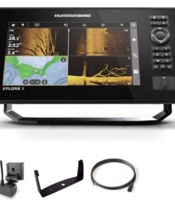
Humminbird XPLORE 9 CMSI+ CHIRP MEGA SI Fish Finder/Chartplotter
Fish Finder & Navigation
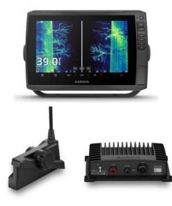
Garmin ECHOMAP Ultra 2 106sv and Garmin LiveScope Plus LVS34 Bundle
Fish Finder & Navigation
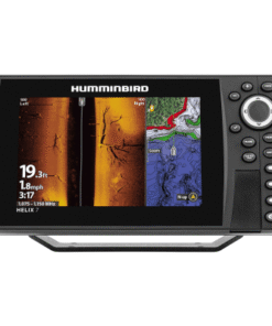
Humminbird HELIX 7 CHIRP SI GPS G4 Fish Finder/Chartplotter – G4
Fish Finder & Navigation
Reviews
There are no reviews yet.