

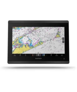
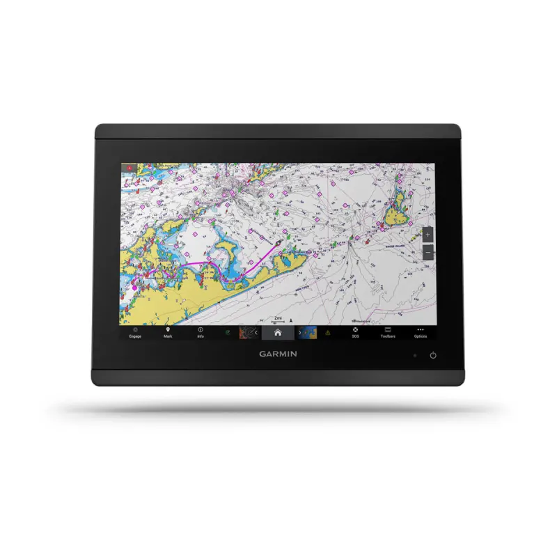
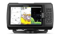
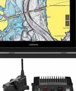
Garmin GPSMAP 8612 12” Chartplotter with Garmin Navionics+ Mapping
€2,715.00
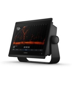
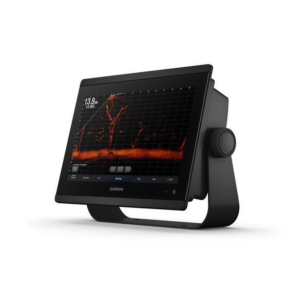
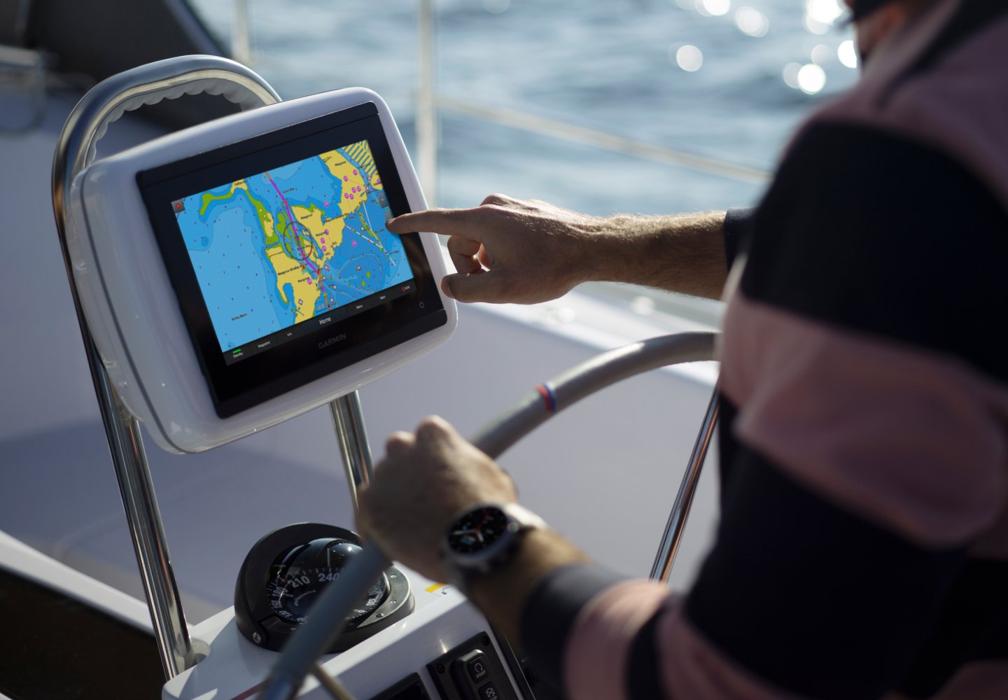
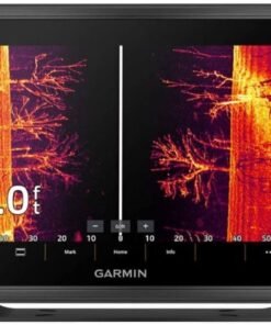
The Garmin® GPSMAP® 8612 12″ Chartplotter with Garmin Navionics+™ Mapping elevates your boating and your expectations. This Garmin multifunction display serves up a 12″ full HD touch-screen display with in-plane switching for wider viewing angles, superior clarity, and sunlight readability, even with polarized sunglasses. It offers built-in support for industry-leading sonar, including dual-channel 1kW traditional CHIRP, CHIRP ClearVü™ and CHIRP SideVü™ scanning sonars, and built-in support for Ultra High-Definition scanning sonar with no black box required. It also supports the LiveScope™ System and the entire live sonar product line, which allow you to clearly see fish swimming around and below your boat in real time (transducers not included). The Garmin 8612 MFD also comes preloaded with Garmin Navionics+ coastal charts and inland mapping with Auto Guidance+™ technology. Plus, there’s support for optional Garmin Navionics Vision+™ premium map content. Experience superior connectivity and networking solutions with complete control of your entire system right at your fingertips. The chartplotter includes a premium-performance processor for Garmin’s fastest map drawing, superior networking, video distribution, and more. Multiple displays can flat-mount edge to edge to create a sleek glass helm look or mounted flush. NMEA 2000® networking and the Garmin Marine Network let you build your full marine electronics suite, from radar and autopilots to cameras and instruments, all controlled from your chartplotter and shared across multiple screens. With SmartMode™ station controls, everything is designed to give you quick, 1-touch access to the information you need to ease high-stress situations such as docking. For full control of your boat on your chartplotter screen, use OneHelm™ to connect to many compatible third-party devices. Built-in Garmin SailAssist™ features provide data, displays, and prerace guidance to gain a competitive edge. Download the ActiveCaptain® app to your smartphone or tablet to manage your marine experience from anywhere, from trip planning and prefishing to purchasing, downloading, and updating maps. See RPMs, fuel flow, temperature, trim and more for up to four of your compatible Mercury® engines by using the SmartCraft® Connect gateway. The GPSMAP 8612 redefines possibilities on the water.
- 12″ full HD touch-screen display
- Wider viewing angles, superior clarity, and sunlight readability
- Compatible with LiveScope live sonar (transducer not included)
- Preloaded with Garmin Navionics+ coastal charts and inland mapping
- Auto Guidance+ technology
- Support for optional Garmin Navionics Vision+ premium map content
- Premium-performance processor
- NMEA 2000 networking
- Garmin Marine Network
- SmartMode 1-touch access to information and controls
- OneHelm third-party device connectivity
- SailAssist sailing enhancements
- SmartCraft Connect gateway for Mercury engine data
Specifications
| Sonar Type | 2D/Down Scanning/Side Scanning |
| Screen Size | 12 inches |
| Transducer Model | None |
| GPS Included | Yes |
| Product Color | Black |
| Live Sonar Compatible | LiveScope Compatible |
| Map/Chart Type | US Freshwater/Saltwater |
| Model Number | 010-02092-50 |
| Pursuit | Saltwater Fishing |
Garmin GPSMAP 8612 12” Chartplotter with Garmin Navionics+ Mapping
Modern navigation has been completely redefined by advanced marine electronics, and at the center of this transformation stands the Garmin GPSMAP 8612 12” Chartplotter with Garmin Navionics+ Mapping. Designed for boaters who demand confidence, clarity, and control, this premium chartplotter has been engineered to elevate every journey on the water—whether coastal cruising, offshore passage-making, or precision fishing is being pursued.
From the very first interaction, a sense of intelligent design is delivered. Every function has been thoughtfully integrated, ensuring that navigation decisions are supported by accurate data, intuitive controls, and real-time situational awareness. Rather than relying on fragmented systems, a unified command center is provided, allowing routes, charts, sonar, radar, and vessel data to be accessed seamlessly.
Because reliability matters most when conditions change, performance has been optimized for both calm waters and challenging environments. With Garmin’s industry-leading technology embedded throughout, navigation is not only simplified—it is strengthened.
Why the Garmin GPSMAP 8612 Stands Apart
Innovation has consistently been associated with Garmin, and that legacy has been carried forward with the GPSMAP 8612. Instead of incremental improvements, a complete navigation experience has been delivered—one that adapts to different boating styles, skill levels, and vessel types.
A New Standard for Marine Chartplotters
Rather than being built solely for experts, this chartplotter has been designed to be inclusive. New boat owners are guided with intuitive layouts, while seasoned captains are empowered through advanced customization options. As a result, confidence is increased for everyone onboard.
At the same time, future-ready architecture has been implemented. System expansion, software updates, and network integration have all been prioritized, ensuring that the chartplotter grows alongside evolving navigation needs.
Stunning 12-Inch Display for Superior Visibility
Large, Bright, and Effortlessly Responsive
A high-resolution 12-inch full HD touchscreen has been integrated to ensure that critical information is always visible at a glance. Even under direct sunlight, clarity is preserved, while wide viewing angles allow data to be read comfortably from different positions at the helm.
Instead of forcing constant zooming or menu switching, more information is displayed simultaneously. As a result, situational awareness is improved, and decision-making becomes faster and more confident.
Key advantages of the display include:
-
Ultra-clear resolution for charts, radar, and sonar overlays
-
Multi-touch functionality for pinch-to-zoom and swipe navigation
-
Sunlight-readable brightness for daytime operation
-
Glove-friendly responsiveness for real-world marine conditions
Because distractions can compromise safety, interaction has been simplified. Every tap, swipe, and command feels natural, reducing the learning curve and keeping focus where it belongs—on the water ahead.
Garmin Navionics+ Mapping: Smarter Charts, Better Decisions
Advanced Marine Cartography Included
With Garmin Navionics+ Mapping included, navigation is transformed into an informed, data-rich experience. Instead of relying on static charts, constantly updated mapping data is delivered, ensuring accuracy across coastal waters, inland lakes, and offshore routes.
Depth contours, navigational aids, and hazard data are presented with remarkable detail. Because updates are applied regularly, confidence is reinforced every time a new voyage is planned.
Mapping features that enhance every trip:
-
Daily chart updates for the first year
-
High-definition depth contours for precise navigation
-
Coverage for coastal, offshore, and inland waters
-
Dock-to-dock route guidance support
-
Advanced shading options to visualize depth changes
Rather than guessing what lies beneath the surface, informed choices are supported through clear, intelligent mapping.
Designed for Seamless Integration
One Display, Endless Possibilities
Networking capabilities have been fully optimized, allowing the Garmin GPSMAP 8612 to function as the central hub of a connected marine system. Engines, radar, sonar modules, autopilots, cameras, and onboard sensors can all be integrated effortlessly.
Because compatibility has been prioritized, expansion is never restricted. As boating needs evolve, additional components can be added without replacing the core system.
Highlighted integration benefits include:
-
NMEA 2000® and NMEA 0183 support
-
Ethernet networking for high-speed data sharing
-
Compatibility with Garmin radar, sonar, and autopilot systems
-
Engine data display and monitoring
-
Multiple display synchronization across the helm
Through this flexible architecture, a truly unified navigation environment is created.
Built for Real-World Marine Conditions
Reliability You Can Trust
Marine environments are unpredictable, which is why durability has been treated as a core design principle. The GPSMAP 8612 has been built to withstand vibration, moisture, and temperature changes without compromising performance.
Instead of fragile consumer-grade components, marine-rated materials have been used throughout. As a result, long-term reliability is delivered—even during extended offshore use.
Core Performance, Processing Power & Intelligent Control
Garmin GPSMAP 8612 12” Chartplotter with Garmin Navionics+ Mapping
Navigation performance has been elevated to an entirely new level through the advanced internal architecture of the Garmin GPSMAP 8612 12” Chartplotter with Garmin Navionics+ Mapping. Rather than relying on outdated processing limitations, cutting-edge computing power has been implemented to ensure that every command, calculation, and visual update is delivered with remarkable speed and accuracy.
Because modern boaters expect instant responsiveness, system latency has been virtually eliminated. Chart redraws, sonar returns, and radar overlays are rendered smoothly, even when multiple data sources are being displayed simultaneously.
High-Performance Processing for Real-Time Navigation
Faster Response, Smarter Decisions
A powerful multi-core processor has been integrated to manage complex marine data without compromise. Instead of slowing down during demanding operations, consistent performance is maintained, allowing critical navigation decisions to be supported in real time.
As a result, routes can be adjusted instantly, hazards can be assessed more quickly, and situational awareness can be preserved—even in congested waterways or fast-changing conditions.
Key processing advantages include:
-
Rapid chart redraws for uninterrupted navigation
-
Smooth multi-layer overlays for radar, sonar, and AIS data
-
Instant menu access without system lag
-
Reliable performance during long-duration operation
Because confidence on the water depends on timely information, speed has been treated as a safety feature—not just a convenience.
Intelligent User Interface Design
Navigation That Feels Instinctive
Rather than overwhelming users with complex menus, an intelligent interface has been developed to keep navigation intuitive and efficient. Core functions are always within reach, while advanced tools remain easily accessible when needed.
By prioritizing usability, time spent learning the system has been minimized. As a result, more time can be spent enjoying the journey rather than managing technology.
Inclusive Design for Every Skill Level
Whether navigation is being handled by a seasoned captain or a new boat owner, the system adapts naturally. Customizable layouts allow preferred data to be displayed prominently, while preset profiles streamline operation for different boating activities.
Interface highlights include:
-
Customizable home screens for personalized workflows
-
Quick-access controls for frequently used features
-
Simple gesture-based navigation using touch inputs
-
Clear visual hierarchy for reduced cognitive load
Because accessibility matters, clarity has been built into every screen.
Advanced Sonar, Radar & AIS Integration
A Complete Situational Awareness Platform
Instead of functioning as a standalone display, the Garmin GPSMAP 8612 has been designed as a fully networked navigation hub. Sonar modules, radar systems, and AIS transceivers can be connected seamlessly, allowing multiple layers of environmental data to be viewed together.
This integrated approach ensures that what lies beneath, around, and ahead of the vessel is clearly understood at all times.
Enhanced awareness is supported through:
-
CHIRP sonar compatibility for sharper target separation
-
SideVü™ and ClearVü™ sonar support for detailed underwater imaging
-
Garmin radar integration for tracking weather and traffic
-
AIS overlays for vessel identification and collision avoidance
Because safety cannot be left to chance, comprehensive data visibility is always maintained.
Effortless Route Planning & Navigation Control
Precision from Dock to Destination
Route planning has been transformed into a streamlined, highly accurate process. Instead of manually plotting waypoints, intelligent guidance tools help chart optimal paths based on chart data and user preferences.
With Garmin Navionics+ Mapping working in harmony with the chartplotter’s processing engine, smoother routes and safer passages are consistently delivered.
Highlighted navigation tools include:
-
Automated route suggestions based on chart data
-
Dynamic waypoint management for flexible planning
-
Real-time course adjustments when conditions change
-
Clear visual route overlays for confident steering
As a result, stress is reduced, and enjoyment on the water is increased.
Multi-Display & Helm Synchronization
One System, Unified Control
For larger vessels or advanced helm setups, synchronization across multiple displays has been fully supported. Instead of operating independent screens, information can be mirrored or customized across the helm, ensuring that every crew member has access to critical data.
Because collaboration improves safety, shared visibility has been prioritized.
Benefits of multi-display networking include:
-
Synchronized chart views across connected displays
-
Independent control options for different helm stations
-
Consistent data sharing without duplication
-
Scalable system design for future upgrades
Real-World Use Cases, Vessel Compatibility & Installation
Garmin GPSMAP 8612 12” Chartplotter with Garmin Navionics+ Mapping
Practical value is ultimately measured by real-world performance, and that is where the Garmin GPSMAP 8612 12” Chartplotter with Garmin Navionics+ Mapping consistently proves its worth. Rather than being designed for a single boating style, this chartplotter has been engineered to adapt seamlessly across fishing, cruising, and offshore navigation scenarios.
Because no two vessels—or journeys—are the same, flexibility has been placed at the core of its design.
Optimized for Fishing Excellence
Precision Tools for Serious Anglers
Fishing success is often determined by clarity, timing, and accurate interpretation of underwater data. For that reason, advanced sonar and mapping capabilities have been fully supported, allowing fishers to locate structures, track bait movement, and identify targets with confidence.
Instead of relying on guesswork, informed decisions are enabled through detailed sonar imaging and responsive chart control.
Highlighted fishing advantages include:
-
Support for CHIRP, ClearVü™, and SideVü™ sonar modules
-
High-definition depth contours for structure identification
-
Waypoint marking for productive fishing spots
-
Smooth zoom and pan control during active fishing sessions
As a result, efficiency is increased, and time on the water is used more effectively.
Built for Confident Cruising
Stress-Free Navigation for Long Journeys
Cruising demands reliability, comfort, and dependable situational awareness. With the GPSMAP 8612, route planning and monitoring have been simplified, allowing more attention to be placed on the experience itself.
Dock-to-dock guidance, combined with real-time chart updates, ensures that routes are planned with clarity and executed with confidence. Because environmental conditions can change quickly, dynamic data presentation supports timely adjustments.
Cruising benefits include:
-
Clear chart visualization for coastal and inland waterways
-
Advanced route guidance to reduce navigational stress
-
AIS integration for traffic awareness
-
Weather and radar overlays for proactive decision-making
Rather than managing multiple systems, a single display delivers comprehensive oversight.
Offshore & Professional Navigation Use
Engineered for Demanding Conditions
Offshore navigation requires equipment that performs without hesitation. The Garmin GPSMAP 8612 has been designed to deliver consistent output even when operating far from shore, where accuracy and reliability are critical.
Because advanced planning and real-time awareness are essential offshore, powerful processing and detailed cartography work together to support safe passage.
Key offshore advantages include:
-
Fast chart redraws during high-speed travel
-
Radar and AIS overlays for collision avoidance
-
Large screen visibility for wave, weather, and route data
-
System redundancy support through networking
As a result, long-distance travel is approached with greater confidence.
Broad Vessel Compatibility
Designed to Fit Your Boat—Not the Other Way Around
Compatibility has been thoughtfully addressed to ensure that the GPSMAP 8612 integrates smoothly across a wide range of vessels. Whether installed on a center console, sportfishing boat, sailboat, or luxury yacht, the system adapts without compromise.
Because vessel layouts vary, flexible mounting and networking options have been provided.
Supported vessel types include:
-
Center consoles and fishing boats
-
Cruisers and yachts
-
Sailboats and catamarans
-
Commercial and professional vessels
This adaptability ensures long-term value, regardless of how boating needs evolve.
Simplified Installation & Expansion
Built for Seamless Setup
Installation has been streamlined to reduce complexity and downtime. With standard networking protocols and clear connectivity options, integration with existing onboard systems is achieved efficiently.
Instead of requiring specialized configurations, expansion is supported through modular design.
Installation and expansion highlights:
-
Flush or bracket mounting options
-
NMEA 2000® and Ethernet connectivity
-
Simple integration with engines and sensors
-
Future-ready expansion for additional Garmin components
Because upgrades should feel empowering—not restrictive—scalability has been prioritized.
Connectivity, Smart Integrations & Long-Term Value
Garmin GPSMAP 8612 12” Chartplotter with Garmin Navionics+ Mapping
Seamless connectivity has become essential in modern marine navigation, and that expectation has been fully addressed by the Garmin GPSMAP 8612 12” Chartplotter with Garmin Navionics+ Mapping. Rather than operating in isolation, this chartplotter has been designed to function as a connected intelligence hub, bringing together onboard systems, digital tools, and real-time data into one cohesive experience.
Because informed navigation depends on timely information, communication pathways have been optimized for reliability and speed.
Advanced Networking & System Connectivity
A Central Command for Your Helm
Multiple connectivity standards have been incorporated to ensure compatibility with a wide range of marine electronics. Instead of limiting expansion, open and widely adopted protocols allow seamless data sharing across the vessel.
As a result, radar, sonar, engine data, sensors, and accessories are synchronized effortlessly.
Key connectivity capabilities include:
-
Ethernet networking for high-speed data transfer
-
NMEA 2000® support for engine and sensor integration
-
NMEA 0183 compatibility for legacy systems
-
Multi-device synchronization across helm stations
Because clarity improves safety, unified system communication has been prioritized.
Mobile Integration & Smart Control
Navigation That Extends Beyond the Helm
Mobile connectivity has been thoughtfully integrated, allowing navigation planning and system management to continue even when away from the helm. Through smart device pairing, data can be synchronized effortlessly between the chartplotter and compatible mobile devices.
With support from Garmin ActiveCaptain, charts, routes, waypoints, and software updates are managed with ease. Rather than interrupting voyages, updates and planning tasks are handled wirelessly.
Mobile integration benefits include:
-
Wireless chart updates and downloads
-
Route planning from a mobile device
-
Smart notifications displayed on the chartplotter
-
Community-sourced marina and hazard data
As a result, navigation preparation becomes more flexible and collaborative.
Software Updates & Future-Proof Support
Built to Evolve with Your Needs
Long-term value has been reinforced through ongoing software support. Instead of becoming outdated, the GPSMAP 8612 continues to improve through regular firmware enhancements and feature expansions.
Because marine technology evolves rapidly, future readiness has been built into the platform.
Highlighted support advantages include:
-
Regular software updates via Wi-Fi
-
Expanded compatibility with new Garmin accessories
-
Continuous performance optimization
-
Long-term product support from Garmin
This commitment ensures that the system remains relevant for years to come.
Data Sharing & Multi-User Collaboration
Navigation for the Whole Crew
Shared visibility and collaboration have been enhanced through synchronized data access. Routes, waypoints, and chart views can be shared across displays, ensuring that everyone onboard remains informed.
Because inclusive navigation improves coordination, multi-user access has been intentionally simplified.
Collaboration features include:
-
Shared route and waypoint libraries
-
Consistent data across helm stations
-
Flexible screen customization for different roles
-
Improved situational awareness for crew members
Exceptional Return on Investment
Premium Performance That Justifies the Upgrade
While positioned as a high-end marine chartplotter, the Garmin GPSMAP 8612 delivers value that extends far beyond its initial purchase. Instead of requiring frequent replacement, its expandable architecture and long-term software support reduce total ownership costs over time.
Because reliability minimizes risk and downtime, operational efficiency is enhanced—whether for recreational or professional use.
Key value drivers include:
-
Reduced need for multiple standalone displays
-
Extended product lifespan through updates
-
Improved safety and navigation accuracy
-
Scalable system design for future upgrades
As a result, peace of mind is delivered alongside measurable performance gains.
Efficient Power Management
Performance Without Excess Consumption
Power efficiency has been optimized to ensure consistent performance without unnecessary strain on onboard electrical systems. Even during extended use, stable operation is maintained.
As a result, reliability is preserved across both short outings and long voyages.
Built for Demanding Marine Environments
Performance That Endures
Internal components have been engineered to deliver consistent output even during extended use. Heat management, power efficiency, and system stability have all been optimized to support long voyages and demanding conditions.
Rather than degrading over time, performance integrity is preserved—voyage after voyage.
| Sonar Type: | 2D-Down Scanning-Side Scanning |
|---|---|
| Color | : Black |
| GPS Included: | Yes |
| Transducer Model: | None |
| Screen Size: | 12 inches |
Be the first to review “Garmin GPSMAP 8612 12” Chartplotter with Garmin Navionics+ Mapping”
Related products
Fish Finder & Navigation
Garmin ECHOMAP Ultra 2 126sv Fish Finder/Chartplotter with Navionics+
Fish Finder & Navigation
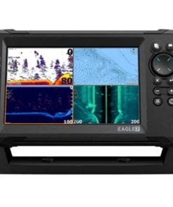
Lowrance Eagle 7 Fish Finder/Chartplotter with SplitShot HD Transducer
Fish Finder & Navigation
Fish Finder & Navigation
Fish Finder & Navigation
Fish Finder & Navigation
Lowrance HDS 12 PRO Fish Finder/Chartplotter with ActiveImaging 3-in-1
Fish Finder & Navigation
Garmin ECHOMAP UHD2 93SV GT54 Transducer with LiveScope Plus LVS34 Bundle
Fish Finder & Navigation
Garmin ECHOMAP UHD2 Touch 93sv Fish Finder/Chartplotter Combo with GT54 Transducer
Reviews
There are no reviews yet.