


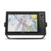
Garmin ECHOMAP UHD2 73sv 7″ Fish Finder/Chartplotter with Navionics+ U.S. Inland Mapping
€500.00

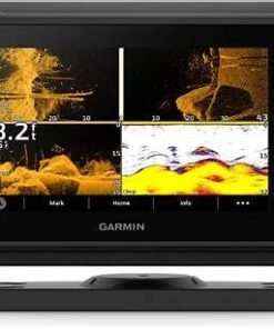
The Garmin® ECHOMAP™ UHD2 73sv 7″ Fish Finder/Chartplotter with Navionics+ U.S. Inland Mapping lets you know the water better than a local. This Garmin fish finder presents clear, sharp fish arches with Garmin traditional sonar. ClearVü™ and SideVü™ scanning-sonar compatibility (transducer not included) produces vivid color palettes for clear, high-contrast views all around your boat. ECHOMAP UHD2 also supports LiveScope™ real-time sonar systems (transducer not included). Navigate the waters with built-in Garmin Navionics+™ cartography. Built-in Wi-Fi® connectivity lets you wirelessly share sonar, waypoints, and routes with another ECHOMAP UHD2 chartplotter. Wherever you drop your line, get improved position accuracy, particularly in areas where signals are reflected or weak, with multi-band GPS. You can also pair with the free all-in-1 ActiveCaptain® app on your compatible smartphone for access to the OneChart™ feature, software updates and more. The chartplotter supports NMEA 2000® networks to connect your compatible autopilots, digital switching, music, and more to view all on 1 screen. It’s the best upgrade you can make for your boating and angling.
Manufacturer model #: 010-02684-00.
- High-resolution 7″ display
- Clear, sharp fish arches
- Garmin traditional sonar
- Support for ClearVu, SideVu, and LiveScope sonars
- Built-in Garmin Navionics+ cartography
- Built-in Wi-Fi
- Multi-band GPS
- Access to all-in-1 ActiveCaptain app
- NMEA 2000 network support
Specifications
| Sonar Type | 2D/Down Scanning/Side Scanning |
| Screen Size | 7 inches |
| Transducer Model | None |
| GPS Included | Yes |
| Product Color | Black |
| Live Sonar Compatible | LiveScope Compatible |
| Map/Chart Type | US Freshwater |
| Model Number | 010-02684-00 |
| Pursuit |
Garmin ECHOMAP UHD2 73sv 7″ Fish Finder/Chartplotter with Navionics+ U.S. Inland Mapping
Precision on the water is no longer optional. Confidence in navigation is expected. Clear sonar imaging is demanded by today’s anglers. For that reason, the Garmin ECHOMAP UHD2 73sv 7″ Fish Finder/Chartplotter with Navionics+ U.S. Inland Mapping is engineered to elevate every freshwater fishing experience.
Developed by Garmin and powered by integrated Navionics+ cartography, this advanced fish finder and chartplotter system is built for anglers of all backgrounds, skill levels, and fishing styles. Whether competitive strategies are being refined or weekend outings are being enjoyed, dependable technology is delivered in a compact, high-performance 7-inch unit.
Built for Inland Fishing Excellence
Designed Specifically for U.S. Lakes and Reservoirs
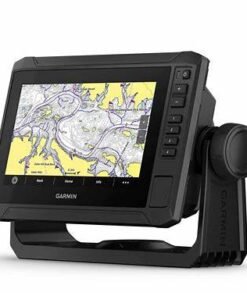
Freshwater fishing requires detailed lake data. Accurate depth readings are essential. Structure visibility is critical. Therefore, preloaded Navionics+ U.S. Inland mapping is included to provide extensive coverage across more than 18,000 lakes.
Depth contours are displayed in fine detail. Shoreline configurations are clearly defined. Submerged structures are mapped precisely. As a result, anglers can make informed decisions based on real underwater terrain rather than guesswork.
Moreover, updated chart data is supported, which means that evolving water conditions can be reflected more reliably over time.
High-Definition Sonar Imaging That Changes the Game
Ultra High-Definition ClearVü & SideVü Technology
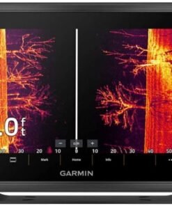
Advanced sonar clarity is delivered through UHD ClearVü and SideVü compatibility. Underwater structures are displayed with near-photographic precision. Fallen timber is outlined sharply. Rock piles are defined distinctly. Suspended fish are separated clearly from surrounding cover.
Additionally, wide scanning coverage is achieved to both sides of the boat. Consequently, more water is analyzed in less time. Strategic casting zones are identified faster. Efficient pattern development becomes possible.
Because side-scanning extends beyond traditional down sonar, blind spots are reduced and structure targeting becomes more precise.
Traditional CHIRP Sonar for Target Separation
Multiple sonar frequencies are transmitted continuously using CHIRP technology. Clear fish arches are displayed. Bottom hardness is distinguished accurately. Thermoclines are identified with greater clarity.
Therefore, fish positioned close to structure can be detected more effectively. In turn, bait placement decisions can be made with increased confidence.
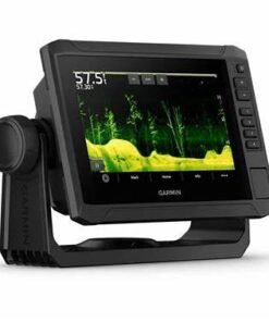
7-Inch Sunlight-Readable Display with Hybrid Controls
Bright, Vivid, and Responsive
A 7-inch high-resolution WVGA display is installed to ensure visibility even under direct sunlight. Glare reduction is optimized. Contrast levels are enhanced. Color palettes are customizable.
As a result, underwater images can be interpreted quickly and accurately in varying light conditions.
Furthermore, high-contrast scanning color schemes are included to help distinguish fish from structure more easily. Visual clarity is prioritized to reduce eye strain during long days on the water.
Touchscreen with Keyed Assist
Versatility is reinforced through a hybrid control system. Touchscreen navigation allows intuitive zooming, panning, and waypoint marking. Physical buttons are integrated for added control during rough water conditions or while wearing gloves.
Therefore, accessibility is increased for all anglers, regardless of experience level or environmental conditions.
Quickdraw Contours: Create Custom HD Maps in Real Time
Unmapped lakes can be explored confidently. Depth contours are recorded automatically. Personalized maps with 1-foot contour intervals are generated instantly.
Because real-time mapping is enabled, anglers can build highly detailed charts of their favorite fishing spots. Furthermore, custom maps can be shared with the Quickdraw Community, strengthening collective fishing knowledge inclusively.
Why This Fish Finder/Chartplotter Matters
Time on the water is valuable. Strategic decisions must be supported by accurate data. Therefore, reliable sonar and detailed inland mapping are essential.
The Garmin ECHOMAP UHD2 73sv 7″ Fish Finder/Chartplotter with Navionics+ U.S. Inland Mapping is designed to reduce uncertainty, enhance situational awareness, and empower anglers to fish smarter.
Garmin ECHOMAP UHD2 73sv 7″ Fish Finder/Chartplotter with Navionics+ U.S. Inland Mapping
Advanced performance is only meaningful when it is supported by intelligent system architecture. Seamless integration is required for modern marine electronics. Long-term reliability must be ensured for consistent results. Therefore, the Garmin ECHOMAP UHD2 73sv 7″ Fish Finder/Chartplotter with Navionics+ U.S. Inland Mapping is engineered not only for clarity, but also for scalability, durability, and precision control.
Built by Garmin and enhanced with preloaded Navionics+ U.S. Inland cartography, this unit is positioned as a comprehensive freshwater navigation and sonar solution.
Advanced Networking & System Expandability
NMEA 2000® Compatibility for Full Integration
Marine systems are strengthened when devices communicate efficiently. Therefore, NMEA 2000® network compatibility is supported to allow seamless expansion.
Engine data can be displayed directly on the screen. Fuel flow information can be monitored. Heading sensors can be integrated. Additional sonar modules and accessories can be connected.
Consequently, a scalable marine electronics ecosystem can be developed without replacing core equipment. Future upgrades are supported. Long-term investment value is preserved.
Waypoint & Data Sharing Between Units
Fishing intelligence increases when information is synchronized. Thus, waypoint sharing between compatible Garmin devices is enabled.
Routes can be transferred. Sonar data can be mirrored. Custom maps can be distributed.
As a result, multi-display setups are streamlined and team-based fishing strategies are strengthened.
Precision GPS & Navigation Control
High-Sensitivity Internal GPS
Accurate positioning is critical when returning to productive fishing spots. Therefore, a high-sensitivity internal GPS receiver is integrated into the system.
Boat position is tracked reliably. Routes are recorded automatically. Waypoints are saved precisely.
Moreover, navigation is supported by detailed contour mapping, which allows depth transitions and structural zones to be followed confidently.
Customizable Navigation Features
Depth shading can be personalized. Safety depth alerts can be configured. Course lines can be adjusted for clarity.
Because navigation flexibility is emphasized, anglers of varying skill levels can tailor the interface according to their comfort and experience.
Rugged Marine Construction for Reliable Performance
Built to Withstand Freshwater Conditions
Electronics used on the water must endure unpredictable environments. Therefore, IPX7 water resistance is incorporated to protect internal components from splashes and incidental exposure.
Heat resistance is reinforced. Vibration tolerance is strengthened. Structural durability is engineered for long-term use.
Consequently, consistent performance is maintained across seasons and varying freshwater conditions.
Compact & Flexible Mounting
A quick-release tilt/swivel mounting bracket is included for straightforward installation. Dash mounting is supported. Bracket mounting is accommodated.
Thus, installation flexibility is enhanced to suit multiple boat configurations, including bass boats, aluminum fishing boats, and small freshwater vessels.
Technical Specifications Breakdown
Display & Interface
-
7-inch WVGA touchscreen display
-
Hybrid touchscreen + keyed assist controls
-
Sunlight-readable brightness optimization
-
High-contrast vivid sonar color palettes
Sonar Capabilities
-
Ultra High-Definition ClearVü scanning sonar support
-
Ultra High-Definition SideVü scanning sonar support
-
Traditional CHIRP sonar technology
-
Enhanced target separation and structure imaging
Mapping & Cartography
-
Preloaded Navionics+ U.S. Inland maps
-
Coverage of 18,000+ lakes
-
1-foot contour mapping on select lakes
-
Quickdraw Contours real-time HD mapping
Connectivity & Networking
-
Built-in Wi-Fi® connectivity
-
ActiveCaptain® app compatibility
-
Waypoint sharing between compatible Garmin chartplotters
-
NMEA 2000® network integration
Durability
-
IPX7 water rating
-
Marine-grade construction
-
Reinforced housing for freshwater use
Because comprehensive specifications are integrated into one device, operational efficiency is improved without added complexity.
How This System Improves Fishing Outcomes
First, sonar clarity reduces misinterpretation of underwater structures. Next, inland contour mapping refines strategic location targeting. Then, waypoint tracking supports repeatable success. Finally, synchronized data sharing enhances collaborative fishing efforts.
As a result, time spent searching is reduced. Energy is conserved. Casting precision is improved.
Moreover, when patterns are tracked seasonally, historical data can be leveraged for future success. Therefore, long-term fishing intelligence is built progressively.
Ideal Applications & Angler Profiles
-
Competitive bass anglers
-
Recreational freshwater fishers
-
Crappie and panfish specialists
-
Reservoir structure hunters
-
Lake navigation enthusiasts
-
Weekend family anglers
Because intuitive controls and professional-grade features are balanced carefully, accessibility and performance coexist inclusively.
Real-World Fishing Scenarios & Strategic Advantages
Structure Fishing Made More Predictable
Submerged brush piles are identified clearly. Rocky transitions are displayed precisely. Drop-offs are visualized accurately.
Because Ultra High-Definition ClearVü and SideVü sonar imaging are supported, structure edges are interpreted with greater confidence. Consequently, casting angles can be adjusted strategically rather than estimated.
Moreover, fish positioned tight to cover can be distinguished more effectively through CHIRP sonar processing. Therefore, missed opportunities are reduced.
Seasonal Pattern Tracking
Water temperature shifts influence fish positioning. Depth migration patterns change throughout the year. Baitfish schools relocate based on environmental factors.
With waypoint memory and contour-based navigation, historical fishing data can be revisited easily. As a result, seasonal trends can be monitored and repeated patterns can be capitalized on.
In addition, custom Quickdraw Contours maps provide personalized depth intelligence, which strengthens long-term familiarity with specific lakes.
Enhanced User Experience for Every Angler
Inclusive Interface Design
Technology adoption should never feel overwhelming. Controls are simplified intentionally. Navigation menus are structured logically. Visual contrast is optimized for readability.
Because hybrid touchscreen and keyed controls are integrated, both tactile and gesture-based interaction styles are supported. Therefore, anglers of varying preferences and abilities can operate the unit comfortably.
Furthermore, customizable display palettes allow color adjustments for individual visibility needs.
Reduced Learning Curve, Increased Confidence
Intuitive menu architecture supports faster onboarding. Preset sonar views simplify interpretation. Guided configuration options assist first-time users.
Consequently, setup time is minimized. On-water adjustment becomes straightforward. Confidence is built progressively through consistent interface feedback.
Installation, Setup & Optimization Tips
Strategic Mount Placement
For optimal visibility, the display should be mounted within direct line of sight. Glare reduction angles should be considered. Cable routing should be secured to prevent interference.
Because stable installation influences long-term durability, mounting hardware should be tightened appropriately.
Sonar Performance Optimization
Transducer placement must remain below turbulent water flow. Proper alignment ensures accurate sonar returns. Calibration settings should be reviewed after installation.
Additionally, sensitivity and gain adjustments can be fine-tuned according to water clarity and depth.
Therefore, sonar returns are interpreted more accurately when configuration is optimized intentionally.
Competitive Edge in the 7-Inch Fish Finder Category
When evaluating 7-inch freshwater fish finders with side scanning sonar and inland mapping, performance consistency becomes a primary differentiator.
The Garmin ECHOMAP UHD2 73sv 7″ Fish Finder/Chartplotter with Navionics+ U.S. Inland Mapping offers:
-
Ultra High-Definition scanning sonar support
-
Detailed inland lake cartography preloaded
-
Built-in Wi-Fi® for ActiveCaptain® integration
-
Custom Quickdraw Contours HD mapping
-
NMEA 2000® network expandability
-
Hybrid touchscreen and button control system
Because these features are consolidated into a mid-size display format, both portability and capability are balanced effectively.
Long-Term Value & Investment Protection
Scalable Technology
Expandable networking ensures future upgrades remain possible. Accessory compatibility supports system growth. Software updates maintain relevance over time.
Consequently, replacement cycles are extended. Technology investment is protected.
Reliable Brand Engineering
Marine electronics must perform under pressure. Garmin engineering standards emphasize quality control, firmware stability, and product longevity.
Therefore, operational downtime is minimized and user confidence is reinforced.
Frequently Asked Questions (FAQ)
Garmin ECHOMAP UHD2 73sv 7″ Fish Finder/Chartplotter with Navionics+ U.S. Inland Mapping
Comprehensive understanding leads to confident purchasing decisions. Therefore, the most common questions about the Garmin ECHOMAP UHD2 73sv 7″ Fish Finder/Chartplotter with Navionics+ U.S. Inland Mapping are addressed below in clear, practical detail.
Developed by Garmin and preloaded with Navionics+ U.S. Inland charts, this system is designed to provide clarity, connectivity, and long-term value for freshwater anglers.
General Product Questions
1. What makes the Garmin ECHOMAP UHD2 73sv 7″ different from other 7-inch fish finders?
Ultra High-Definition ClearVü and SideVü sonar compatibility is supported. Traditional CHIRP sonar is integrated. Navionics+ U.S. Inland mapping is preloaded. Built-in Wi-Fi® connectivity is included.
Therefore, advanced sonar imaging and detailed inland mapping are combined into one streamlined unit. Additionally, hybrid touchscreen and keyed controls provide flexible operation.
2. Is this fish finder designed specifically for freshwater use?
Yes. Navionics+ U.S. Inland mapping is preloaded with coverage for over 18,000 lakes across the United States.
Depth contours are displayed in fine detail on supported lakes. Shorelines and structures are mapped precisely. Consequently, it is optimized for inland lakes, reservoirs, and rivers.
3. Does the unit include GPS?
A high-sensitivity internal GPS receiver is integrated.
Boat position is tracked accurately. Waypoints are saved precisely. Routes are recorded automatically. Therefore, returning to productive fishing locations becomes reliable and repeatable.
Sonar & Imaging Questions
4. What sonar technologies are supported?
-
Ultra High-Definition ClearVü scanning sonar (compatible transducer required)
-
Ultra High-Definition SideVü scanning sonar (compatible transducer required)
-
Traditional CHIRP sonar
Because multiple sonar technologies are supported, underwater structure and fish targets can be interpreted more clearly.
5. What is the advantage of CHIRP sonar?
Multiple frequencies are transmitted continuously rather than a single pulse.
As a result, target separation is improved. Fish positioned close to structure are distinguished more accurately. Bottom detail is rendered more precisely.
6. Can I create my own lake maps?
Yes. Quickdraw Contours software is built into the device.
Custom HD maps with 1-foot contour intervals can be generated in real time. Therefore, unmapped lakes can be explored confidently and personalized depth data can be recorded.
Mapping & Navigation Questions
7. What is included with Navionics+ U.S. Inland mapping?
More than 18,000 inland lakes are covered.
Many lakes feature 1-foot contour detail. Shoreline structures and navigation aids are displayed clearly. Furthermore, updates are supported to maintain chart accuracy.
8. Can depth shading be customized?
Depth shading and safety depth alerts can be configured.
Because visual customization is supported, anglers can highlight productive depth ranges based on seasonal patterns or target species.
9. Can waypoints be shared between devices?
Waypoint and route sharing is supported between compatible Garmin chartplotters.
Consequently, fishing intelligence can be synchronized across multiple units.
Connectivity & Compatibility
10. Does this fish finder support Wi-Fi?
Built-in Wi-Fi® connectivity is included.
The ActiveCaptain® app can be connected wirelessly. Software updates can be downloaded. Waypoints can be backed up.
Therefore, digital management is simplified without additional hardware.
11. Is NMEA 2000® networking supported?
Yes. NMEA 2000® compatibility is integrated.
Engine data, heading sensors, and additional marine electronics can be connected. As a result, a scalable electronics network can be developed over time.
12. Is a transducer included?
Package configurations may vary depending on the selected bundle.
Ultra High-Definition ClearVü and SideVü capabilities require compatible Garmin transducers. Therefore, buyers should confirm included components before purchase.
Installation & Durability
13. Is the unit waterproof?
An IPX7 water rating is supported.
Protection against incidental water exposure is ensured. However, full submersion is not recommended.
14. Is installation complicated?
A quick-release tilt/swivel mounting bracket is included.
Dash mounting and bracket mounting options are supported. Therefore, installation flexibility is provided for multiple freshwater boat setups.
15. Can the display be viewed in bright sunlight?
The 7-inch WVGA display is engineered for sunlight readability.
High-contrast vivid color palettes are available. Glare reduction is optimized. Consequently, clarity is maintained even in direct daylight conditions.
Performance & Use Case Questions
16. Is this unit suitable for tournament fishing?
Advanced sonar clarity, detailed contour mapping, and waypoint management support competitive fishing strategies.
Therefore, tournament anglers benefit from precise structure identification and repeatable location tracking.
17. Is it beginner-friendly?
Hybrid controls, intuitive menus, and preset sonar views simplify onboarding.
Because user accessibility is prioritized, anglers of varying experience levels can operate the device confidently.
18. What type of fishing is it best suited for?
-
Bass fishing in reservoirs
-
Crappie and panfish targeting
-
Structure-based fishing
-
Seasonal pattern tracking
-
Inland lake navigation
Consequently, versatility across freshwater environments is supported.
Purchase & Value Questions
19. Is this a long-term investment?
Expandable networking ensures future upgrades remain possible. Software updates maintain functionality. Durable marine-grade construction supports extended use.
Therefore, long-term value is reinforced.
20. Why choose the Garmin ECHOMAP UHD2 73sv 7″ Fish Finder/Chartplotter with Navionics+ U.S. Inland Mapping?
Ultra High-Definition sonar imaging is supported. Detailed inland mapping is preloaded. Wireless connectivity is integrated. Expandable networking is available.
Because clarity improves accuracy and accuracy increases success, this system empowers anglers to navigate confidently and fish strategically.
| Sonar Type: | 2D-Down Scanning-Side Scanning |
|---|---|
| Color | : Black |
| GPS Included: | Yes |
| Transducer Model: | None |
| Screen Size: | 7 inches |
Be the first to review “Garmin ECHOMAP UHD2 73sv 7″ Fish Finder/Chartplotter with Navionics+ U.S. Inland Mapping”
Related products
Fish Finder & Navigation
Fish Finder & Navigation
Garmin ECHOMAP Ultra 2 106sv Fish Finder/Chartplotter with Navionics+
Fish Finder & Navigation
Fish Finder & Navigation
Garmin ECHOMAP Ultra 2 126sv Fish Finder/Chartplotter with Navionics+
Fish Finder & Navigation
Lowrance HDS 12 PRO Fish Finder/Chartplotter with ActiveImaging 3-in-1
Fish Finder & Navigation
Garmin ECHOMAP UHD2 93SV GT54 Transducer with LiveScope Plus LVS34 Bundle
Fish Finder & Navigation
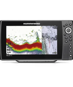
Humminbird HELIX 10 CHIRP MEGA SI GPS G4N Fish Finder/Chartplotter
Fish Finder & Navigation
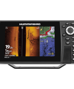
Humminbird HELIX 7 CHIRP SI GPS G4 Fish Finder/Chartplotter – G4
Reviews
There are no reviews yet.