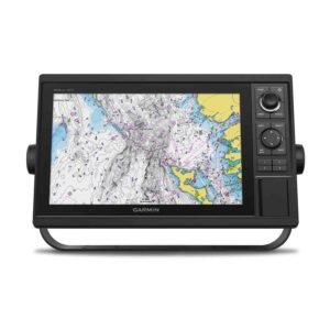
Garmin GPSMAP 1242xsv 12″ Chartplotter with Sonar, Garmin Navionics+ Mapping, and GT52HW-TM Transducer
€1,800.00
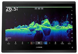
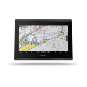
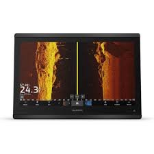
Experience an advanced all-in-1 solution with the Garmin® GPSMAP® 1242xsv 12″ Chartplotter with Sonar, Garmin Navionics+ Mapping, and GT52HW-TM Transducer. This powerhouse Garmin chartplotter has a large, bright screen coupled with a keypad interface and multifunction control knob. A GT52-TM transducer gives you Garmin CHIRP sonar along with CHIRP ClearVü™ and CHIRP SideVü™ scanning sonars. There’s also support for Panoptix™ and LiveScope™ live sonars (transducers not included). Preloaded Garmin Navionics+™ coastal charts and inland mapping features Auto Guidance+™ technology. Plus, there’s support for optional Garmin Navionics Vision+™ premium map content. This GPSMAP combo also boasts Quickdraw Contours software and the Quickdraw Community on the Garmin Connect™ online network. Use built-in Wi-Fi® technology to pair with the free ActiveCaptain® smartphone app for access to the OneChart™ feature, smart notifications, Garmin Quickdraw™ Community data, and more. Garmin Marine Network support allows sharing of sonar, maps, user data, radar, IP cameras, and live sonar among multiple units. Plus, there’s NMEA 2000® and NMEA 0183 network connectivity support including autopilots, digital switching, weather, media, VHF, AIS, and other sensors. These units also include integrated ANT® connectivity support for use with compatible quatix® smartwatches, the gWind™ Wireless 2 transducer, GNX™ Wind marine instrument, and remote controls (not included). See RPMs, fuel flow, temperature, trim, and more for up to four of your compatible Mercury® engines by using the SmartCraft® Connect gateway. The Garmin GPSMAP redefines possibilities on the water.
- 12″ extra-sharp display
- Large, bright screen with keypad interface and multifunction control knob
- GT52-TM transducer with Garmin CHIRP sonar and CHIRP ClearVü and SideVü scanning sonars
- Support for Panoptix and LiveScope live sonars (transducers not included)
- Quickdraw Contours
- Built-in Wi-Fi
- Garmin Connect online network
- Garmin Marine Network support
- NMEA 2000 and NMEA 0183 network connectivity support
- Integrated ANT connectivity
- SmartCraft Connect gateway data for Mercury engines
Specifications
| Sonar Type | 2D/Down Scanning/Side Scanning |
| Screen Size | 12 inches |
| Transducer Model | GT52 |
| GPS Included | Yes |
| Product Color | Black |
| Live Sonar Compatible | LiveScope Compatible |
| Map/Chart Type | US Freshwater/Saltwater |
| Model Number | 010-01741-60 |
| Pursuit | Saltwater Fishing |