
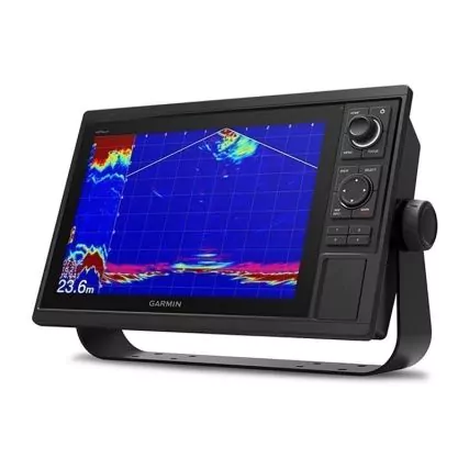
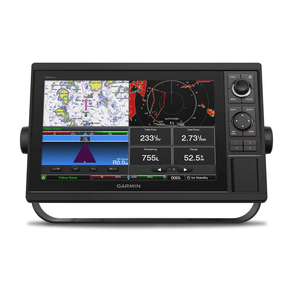
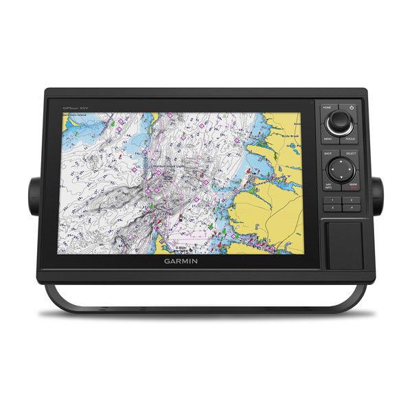
Garmin GPSMAP 1222 Fish Finder/Chartplotter
€1,280.00

The Garmin® GPSMAP 1222 Fish Finder/Chartplotter is designed for cruisers, sailors, and sailing racers who need the advanced all-in-1 solution. This Garmin chartplotter sports a large, bright, 12″ display with quick and easy-to-use keypad interface. User-programmable keys and a multifunction control knob let you effortlessly dial in your optimal settings.
- Bright, 12″, high-resolution display
- Designed for cruisers, sailors, and sailing racers
- Keypad interface
- User-programmable keys
- Multifunction control knob
Specifications
| Sonar Type | 2D/Down Scanning/Side Scanning |
| Screen Size | 12 inches |
| Transducer Model | None |
| GPS Included | Yes |
| Product Color | Black |
| Live Sonar Compatible | LiveScope Compatible |
| Map/Chart Type | None |
| Model Number | 010-01741-00 |
| Pursuit | Saltwater Fishing |
Description
Garmin GPSMAP 1222 Fish Finder/Chartplotter Purpose-Driven Marine Technology for Confident Navigation
Modern marine navigation has been redefined by expectations of accuracy, clarity, and adaptability. As a result, equipment choices are no longer made casually. Instead, investments are carefully evaluated for long-term reliability, performance scalability, and inclusive usability. Within that context, the Garmin GPSMAP 1222 Fish Finder/Chartplotter has been positioned as a professional-grade solution that balances advanced capability with intuitive control.
Developed by Garmin, this chartplotter has been engineered to support both precision fishing and dependable navigation across a wide range of marine environments. Rather than focusing solely on raw specifications, emphasis has been placed on real-world functionality. Consequently, situational awareness is enhanced without unnecessary complexity being introduced.
Because marine conditions can change rapidly, responsive technology has been prioritized. Processing speed, display clarity, and system integration have therefore been optimized to work together seamlessly. Through this approach, decision-making on the water is supported with confidence rather than guesswork.
Understanding the Garmin GPSMAP 1222 at a Glance
A Unified Fish Finder and Chartplotter Experience
Instead of requiring multiple standalone devices, a consolidated solution has been provided. Fish-finding intelligence and chartplotting capability are combined into a single, streamlined system. By doing so, helm clutter is reduced while operational efficiency is improved.
Navigation charts, sonar data, and vessel information are displayed cohesively. Because the interface has been designed with logical layering, critical information remains accessible without visual overload. As a result, focus can remain on the water rather than on navigating menus.
Designed With Scalability in Mind
Boating needs rarely remain static. Therefore, system expandability has been intentionally supported. The Garmin GPSMAP 1222 Fish Finder/Chartplotter allows additional components to be integrated over time, ensuring that future requirements can be met without full system replacement.
Through network connectivity, radar, sonar modules, autopilot systems, and engine data can be added. This flexibility ensures that evolving skill levels and operational demands are accommodated inclusively.
Display Performance and Visual Clarity
12-Inch Touchscreen Built for Real-World Conditions
Visibility plays a critical role in marine safety and fishing success. For that reason, a large 12-inch high-resolution touchscreen has been implemented. Rather than prioritizing size alone, display brightness and contrast have been carefully calibrated.
Sunlight readability has been enhanced so that glare interference is minimized. Meanwhile, color differentiation has been refined to ensure that charts, contours, and sonar returns remain easily distinguishable. Because visual fatigue can compromise judgment, long-term viewing comfort has also been considered.
Intuitive Touch Control With Physical Reliability
Touch input responsiveness has been optimized to perform reliably in marine environments. Even when conditions become less than ideal, interactions remain consistent. Gestures such as pinch-to-zoom and drag navigation are supported, allowing chart exploration to feel natural rather than forced.
At the same time, the interface layout has been designed to remain accessible for users with varying levels of technical familiarity. Inclusivity has therefore been supported by reducing unnecessary learning curves.
Navigation Intelligence That Inspires Confidence
Advanced Chartplotter Functionality
Navigation accuracy is reinforced through compatibility with a wide range of marine charts. Coastal cruising, offshore routing, and inland waterway navigation are all supported within the same platform. Because chart data is rendered smoothly, route planning feels fluid rather than fragmented.
Waypoints, tracks, and routes are managed efficiently, allowing trips to be planned in advance or adjusted dynamically. As a result, situational awareness is strengthened regardless of voyage complexity.
Reliable Positioning and Course Awareness
Precise GPS positioning has been integrated to ensure dependable location tracking. Rather than relying on delayed updates, real-time movement is reflected accurately on screen. Consequently, course adjustments can be made proactively instead of reactively.
Heading, speed, and positional data are displayed clearly, contributing to safer navigation practices for all onboard.
A Marine Navigation System Built Around Real People and Real Use Cases
Boating communities are diverse. Experience levels vary, vessel types differ, and goals on the water are rarely identical. For that reason, assumptions have been intentionally avoided in the design of the Garmin GPSMAP 1222 Fish Finder/Chartplotter. Instead, a flexible and inclusive approach has been taken.
Rather than limiting functionality to a narrow user profile, this system has been engineered to adapt. As a result, both newcomers and seasoned professionals are supported without compromise. Confidence is built not through complexity, but through clarity and reliability.
Because marine environments demand focus, unnecessary barriers to use have been removed. Learning curves have been softened, and customization options have been provided so that the interface can reflect individual preferences.
Designed for Recreational Anglers Seeking Confidence
Supporting Skill Development Without Overwhelm
For recreational anglers, reliable information can make the difference between frustration and fulfillment. With that understanding, fish-finding and navigation data are presented in a way that feels approachable rather than intimidating.
Instead of forcing technical interpretation, sonar visuals and chart data are rendered intuitively. Consequently, patterns begin to emerge naturally over time. As familiarity increases, deeper functionality can be explored at a comfortable pace.
Because progress in fishing is often gradual, long-term usability has been emphasized. The system grows alongside the user rather than outpacing them.
Enhancing Enjoyment on Every Trip
Enjoyment on the water is supported when stress is reduced. Through stable GPS positioning and clear route visualization, uncertainty is minimized. As a result, attention can remain on the experience itself rather than on constant recalculation.
Whether short outings or extended days are planned, reliability remains consistent.
Built for Offshore and Coastal Fishing Enthusiasts
Reliable Performance Where Conditions Are Unpredictable
Offshore environments introduce variables that cannot be ignored. Changing weather, shifting currents, and extended distances all place greater demands on navigation equipment. In response, the Garmin GPSMAP 1222 Fish Finder/Chartplotter has been designed to maintain performance consistency even when conditions become challenging.
Because processing speed remains stable, data refresh rates are not compromised. Consequently, situational awareness is preserved at critical moments.
Confidence Through Expanded Situational Awareness
When paired with compatible sonar and radar systems, a broader picture of the marine environment is formed. Instead of relying on fragmented information, a unified display supports informed decisions.
As a result, fishing strategies and navigational choices are guided by data rather than assumption.
A Practical Solution for Professional and Commercial Use
Supporting High-Responsibility Marine Operations
For charter operators, guides, and commercial users, reliability is not optional. Equipment downtime can impact safety, schedules, and livelihoods. With this in mind, the system has been engineered for consistent performance over extended periods of use.
Rather than requiring constant adjustment, stability is maintained. Interfaces remain responsive, and data remains accessible throughout long operating days.
Adaptability for Multi-User Environments
In professional settings, multiple individuals may interact with the same helm. Because of this, intuitive design becomes essential. The Garmin GPSMAP 1222 Fish Finder/Chartplotter supports user customization without locking the system into rigid profiles.
As a result, transitions between operators are smoother, and errors caused by unfamiliarity are reduced.
Accessibility and Inclusive Design Considerations
Visual Clarity for Diverse Viewing Needs
Inclusive design has been supported through attention to display clarity and contrast. Information hierarchy is clearly defined, allowing essential data to stand out without being buried.
Because readability remains consistent across lighting conditions, users with varying visual sensitivities are better supported. This contributes to safer and more comfortable operation for everyone onboard.
Simplified Interaction Without Sacrificing Depth
While advanced features are available, they are not forced. Instead, access is layered. Core functionality remains immediately usable, while deeper settings are available when needed.
This approach respects different comfort levels with technology and avoids unnecessary exclusion.
Vessel Compatibility and Use-Case Versatility
Suitable for a Wide Range of Boat Types
Rather than being restricted to a specific vessel category, the Garmin GPSMAP 1222 Fish Finder/Chartplotter has been designed for broad compatibility.
Common installations include:
-
Center console fishing boats
-
Offshore sportfishing vessels
-
Coastal cruisers
-
Dual-console and walkaround boats
-
Professional charter boats
Because mounting flexibility is supported, integration into existing helms is simplified.
Adaptable Across Water Types
Freshwater and saltwater environments present different challenges. Fortunately, this system has been engineered to perform reliably across both.
Lakes, rivers, coastal waters, and offshore routes are all supported through compatible chart data and sonar configurations. As a result, seasonal or location-based transitions are handled smoothly.
Seeing Beneath the Surface With Greater Clarity and Purpose
Successful fishing has always depended on understanding what lies beneath the waterline. However, guesswork has increasingly been replaced by data-driven insight. In response to this shift, the Garmin GPSMAP 1222 Fish Finder/Chartplotter has been designed to support advanced sonar technologies that transform underwater environments into readable, actionable information.
Rather than presenting abstract signals, sonar data is translated into visual representations that can be interpreted intuitively. As a result, structure, depth changes, and fish presence are identified with greater confidence. Because information is delivered in real time, decisions are guided by current conditions rather than outdated assumptions.
Through this approach, fishing strategies are refined while time on the water is used more efficiently.
Sonar Compatibility That Supports Long-Term Flexibility
Transducer Integration Without Restrictive Limitations
Rather than locking users into a single sonar configuration, compatibility has been intentionally broadened. The Garmin GPSMAP 1222 Fish Finder/Chartplotter supports a wide range of Garmin sonar transducers, allowing setups to be tailored to specific fishing styles and environments.
Because transducers are selected separately, flexibility is preserved. As experience grows or fishing locations change, sonar capability can be expanded without replacing the core system. Consequently, investment value is protected over time.
High-Frequency and Traditional Sonar Support
Traditional CHIRP sonar remains a trusted tool for depth tracking and target separation. Through high-frequency signal processing, fish arches and bottom contours are displayed with improved resolution.
Rather than blending targets together, individual returns are distinguished clearly. This separation allows species identification and depth estimation to be performed more accurately.
ClearVu Sonar: High-Definition Downward Imaging
Interpreting Bottom Structure With Confidence
ClearVu scanning sonar provides a near-photographic view of what lies directly beneath the vessel. Instead of relying on abstract sonar arches alone, underwater terrain is displayed in a form that resembles natural shapes.
Rocks, vegetation, drop-offs, and submerged objects are revealed with remarkable clarity. Because these features are presented visually, interpretation becomes faster and more intuitive.
As a result, productive fishing areas are identified with less trial and error.
Reducing False Assumptions in Fishing Decisions
When underwater information is unclear, assumptions often guide decisions. With ClearVu imagery, ambiguity is reduced. Fish can be distinguished from structure, and bottom composition can be evaluated accurately.
This clarity supports more deliberate lure placement and depth selection, contributing to higher success rates over time.
SideVu Sonar: Expanding Awareness Beyond the Boat
Wide-Area Scanning for Strategic Advantage
Rather than limiting sonar visibility to the area directly beneath the vessel, SideVu scanning extends awareness outward on both sides. This expanded view allows large sections of water to be covered efficiently.
As a result, structure and fish-holding areas are located without repeatedly passing directly over them. This not only saves time but also reduces disturbance in sensitive fishing zones.
Enhanced Coverage for Offshore and Inland Use
SideVu sonar proves valuable in both offshore and inland environments. Wrecks, ledges, vegetation lines, and submerged features are revealed with clarity across wide scanning ranges.
Because information is presented in a clear lateral layout, spatial relationships are understood more easily. Consequently, approach strategies can be planned with greater precision.
Real-Time Data Processing and Display Optimization
Fast Processing for Immediate Interpretation
Sonar effectiveness is not determined by signal quality alone. Processing speed plays an equally important role. The Garmin GPSMAP 1222 Fish Finder/Chartplotter has been engineered to process incoming sonar data rapidly.
Because delays are minimized, screen updates remain smooth even at higher speeds. As a result, accuracy is maintained whether trolling slowly or moving between locations.
Customizable Sonar Views for Individual Preference
Different anglers interpret data differently. For this reason, display layouts can be customized. Split-screen views allow sonar, charts, and additional data to be viewed simultaneously.
Color palettes, gain settings, and depth ranges can also be adjusted. This flexibility supports inclusivity by accommodating varied visual preferences and fishing styles.
Garmin GPSMAP 1222 Fish Finder Supporting Smarter Fishing Strategies
Pattern Recognition Over Time
Rather than offering isolated data points, sonar information accumulates into recognizable patterns. Depth transitions, structure locations, and fish behavior trends become clearer with repeated use.
Because historical waypoints and tracks can be combined with sonar observations, future trips are informed by past success. This reinforces learning rather than resetting knowledge each outing.
Garmin GPSMAP 1222 Fish Finder Reducing Time Spent Searching
Time efficiency is improved when productive areas are identified quickly. By reducing blind searching, more time can be dedicated to actual fishing.
Consequently, both enjoyment and effectiveness are enhanced regardless of experience level.

Precision Navigation Designed to Reduce Uncertainty on the Water
Navigation has always been central to safe and successful boating. However, modern expectations extend beyond basic positioning. Accuracy, clarity, and adaptability are now essential. With those needs in mind, the Garmin GPSMAP 1222 Fish Finder/Chartplotter has been designed to deliver intelligent navigation support that remains dependable across diverse marine environments.Garmin GPSMAP 1222 Fish Finder
Rather than presenting static chart data, dynamic navigation information is delivered in real time. As a result, changing conditions are reflected immediately, allowing informed adjustments to be made without delay. Because uncertainty can compromise safety, clarity has been prioritized at every stage of the navigation experience.
Garmin GPSMAP 1222 Fish Finder Comprehensive Chart Compatibility for Broad Coverage
Supporting Multiple Chart Formats
Marine navigation needs vary widely depending on location and use case. For that reason, compatibility with a broad range of chart formats has been supported. Coastal waters, inland routes, and offshore passages can all be navigated within a single system.
Charts are rendered smoothly, ensuring that zooming and panning remain fluid rather than disruptive. Consequently, situational awareness is preserved even when navigating complex waterways.
Seamless Integration With Premium Mapping Options
High-detail mapping options can be utilized to enhance route planning and hazard awareness. Depth contours, navigation aids, and shoreline details are displayed with precision.
Because chart information is layered intelligently, critical details remain visible without clutter. This balance supports quick interpretation while maintaining comprehensive coverage.
Waypoint, Route, and Track Management
Organized Navigation Planning
Waypoints serve as the foundation of effective navigation and fishing strategy. Through the Garmin GPSMAP 1222 Fish Finder/Chartplotter, waypoint creation and management are handled intuitively.
Rather than navigating through complicated menus, locations can be marked quickly and revisited with ease. Routes can be planned in advance or adjusted dynamically as conditions change.
Tracking Movement for Improved Awareness
Tracks provide valuable insight into vessel movement over time. By reviewing track history, navigation patterns can be analyzed and refined.
Because track data is stored reliably, successful routes can be repeated while inefficiencies are avoided. This contributes to both fuel efficiency and time management.
Garmin GPSMAP 1222 Fish Finder GPS Accuracy and Real-Time Positioning
Dependable Location Tracking
Accurate GPS positioning is critical for safe navigation. With precise satellite data integration, location updates are reflected consistently on screen.Garmin GPSMAP 1222 Fish Finder
Rather than lagging behind vessel movement, real-time tracking ensures that heading, speed, and position remain current. As a result, course corrections can be made proactively.
Enhanced Confidence in Challenging Conditions
Fog, low visibility, and unfamiliar waters introduce additional risk. In such situations, dependable GPS data becomes even more valuable.Garmin GPSMAP 1222 Fish Finder
By maintaining accurate positional awareness, the Garmin GPSMAP 1222 Fish Finder/Chartplotter supports safer navigation decisions even when visual cues are limited.Garmin GPSMAP 1222 chartplotter
Garmin GPSMAP 1222 chartplotter Safety-Focused Navigation Features
Situational Awareness That Supports Decision-Making
Navigation safety extends beyond knowing where the boat is located. Understanding surrounding hazards, depth changes, and navigational markers is equally important.
Because this information is displayed clearly and contextually, risks are identified earlier. Consequently, reaction time is improved and stress is reduced.
Garmin GPSMAP 1222 chartplotter Reducing Cognitive Load at the Helm
In high-attention environments, cognitive overload can be dangerous. For that reason, the interface has been designed to present essential information without distraction.Garmin GPSMAP 1222 Fish Finder
By organizing data logically and minimizing unnecessary alerts, focus is preserved. This inclusive design approach supports safer operation for all users.
Garmin GPSMAP 1222 Fish Finder Adaptability Across Navigation Scenarios
Offshore, Coastal, and Inland Versatility
Different water types demand different navigation approaches. Fortunately, this system adapts effectively across environments.
Offshore routes benefit from wide-area charting and precise GPS positioning. Coastal navigation is supported through detailed shoreline mapping. Inland waterways are handled with the same clarity and responsiveness.
As a result, transitions between environments are managed seamlessly.
Supporting Both Planned and Spontaneous Journeys
Not every trip follows a strict plan. Because of this, flexibility has been built into the navigation experience.
Routes can be modified on the fly, waypoints can be added as discoveries are made, and navigation data adjusts in real time. This responsiveness encourages exploration without compromising safety.
Frequently Asked Questions (FAQ)
Garmin GPSMAP 1222 Fish Finder/Chartplotter
What is the Garmin GPSMAP 1222 Fish Finder/Chartplotter used for?
The Garmin GPSMAP 1222 Fish Finder/Chartplotter is used for marine navigation and fish detection. Accurate GPS positioning is combined with advanced sonar compatibility, allowing underwater structure, fish targets, and navigation routes to be viewed on a single display. As a result, safer navigation and more informed fishing decisions are supported across offshore, coastal, and inland waters.
Does the Garmin GPSMAP 1222 include a transducer?
No transducer is included by default. Instead, compatibility with a wide range of Garmin transducers is supported. This approach allows sonar capability to be customized based on fishing style, water depth, and preferred sonar technology. Consequently, long-term flexibility is preserved.
What sonar technologies are supported?
Multiple sonar technologies are supported, including:
-
Traditional CHIRP sonar
-
ClearVu scanning sonar
-
SideVu scanning sonar
When compatible transducers are paired, high-definition underwater imaging is enabled. Because sonar options are expandable, capability can evolve alongside user needs.
Is the Garmin GPSMAP 1222 suitable for offshore fishing?
Yes, offshore use is fully supported. Reliable GPS positioning, fast processing performance, and advanced sonar compatibility make the system well-suited for offshore environments. In addition, chart compatibility allows long-distance route planning and situational awareness to be maintained even when conditions become unpredictable.
Can this chartplotter be used on freshwater lakes and rivers?
Freshwater environments are fully supported. Inland lakes, rivers, and reservoirs can be navigated using compatible charts and sonar configurations. As a result, seasonal transitions between saltwater and freshwater use are handled without limitation.Garmin GPSMAP 1222 chartplotter
What size is the display, and is it sunlight-readable?
A 12-inch high-resolution touchscreen display is used. Brightness and contrast have been optimized for marine conditions, allowing visibility to remain strong even in direct sunlight. Because glare reduction has been considered, long-term viewing comfort is also supported.Garmin GPSMAP 1222 chartplotter
Is the touchscreen easy to use while boating?
Touchscreen responsiveness has been optimized for marine environments. Gestures such as pinch-to-zoom and drag navigation are supported, making interaction feel intuitive. At the same time, interface layouts are designed to reduce accidental inputs, supporting reliable use while underway.
Can radar, autopilot, or engine data be connected?
Yes. Network connectivity allows compatible radar systems, autopilot controls, and engine data to be integrated. This expandable architecture enables the Garmin GPSMAP 1222 Fish Finder/Chartplotter to function as part of a broader marine electronics ecosystem.
Does it support split-screen or customizable layouts?
Custom screen layouts are supported. Multiple data sources—such as sonar, charts, and navigation data—can be viewed simultaneously using split-screen configurations. Because layouts can be adjusted, individual preferences and accessibility needs are accommodated.
Is this chartplotter suitable for professional or commercial use?
Professional and commercial use is supported. Reliability, expandability, and consistent performance make the system suitable for charter operators, guides, and commercial vessels. In multi-user environments, intuitive operation helps reduce training time and operational errors.
How accurate is the GPS positioning?
High-precision GPS positioning is provided through reliable satellite data integration. Location updates are reflected in real time, ensuring that heading, speed, and positional awareness remain accurate. This contributes directly to safer navigation practices.
Can routes and waypoints be saved for future trips?
Yes, waypoints, routes, and tracks can be saved and managed efficiently. Historical navigation data can be reviewed and reused, allowing successful fishing locations and safe routes to be repeated over time.
Is the Garmin GPSMAP 1222 beginner-friendly?
Beginner usability has been intentionally supported. Core features are accessible without requiring advanced technical knowledge, while deeper functionality remains available as experience grows. This layered approach prevents overwhelm while encouraging skill development.
What types of boats is this system compatible with?
Compatibility is broad and includes:
-
Center console boats
-
Offshore sportfishing vessels
-
Coastal cruisers
-
Walkaround and dual-console boats
-
Professional charter boats
Because mounting flexibility is supported, integration into most helm layouts is simplified.
Does this device work with marine charts from Garmin?
Yes. The system is designed to work seamlessly with compatible Garmin marine charts. High-detail mapping enhances route planning, depth awareness, and hazard identification.
Developed by Garmin, the chart ecosystem emphasizes accuracy and clarity.
Is the Garmin GPSMAP 1222 a long-term investment?
Long-term value has been prioritized. Expandable networking, transducer flexibility, and software-driven capability allow the system to remain relevant as needs change. Rather than requiring frequent replacement, growth is supported through modular upgrades.
Additional information
| Sonar Type: | 2D-Down Scanning-Side Scanning |
|---|---|
| GPS Included: | Yes |
| Transducer Model: | None |
| Screen Size: | 12 inches |
Related products
-
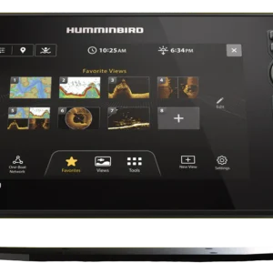
Humminbird XPLORE 12 CMSI+ CHIRP MEGA SI Fish Finder/Chartplotter
€2,000.00Select options This product has multiple variants. The options may be chosen on the product page -

Garmin STRIKER Vivid 9sv Fish Finder
€350.00Select options This product has multiple variants. The options may be chosen on the product page -

Lowrance Elite FS 10 Fish Finder/Chartplotter with TotalScan Transducer
€657.00Select options This product has multiple variants. The options may be chosen on the product page -

Lowrance Elite FS 9 Fish Finder/Chartplotter Combo
Price range: €500.00 through €645.00Select options This product has multiple variants. The options may be chosen on the product page
Reviews
There are no reviews yet.