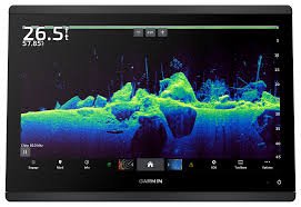
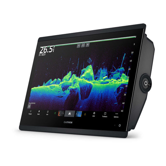
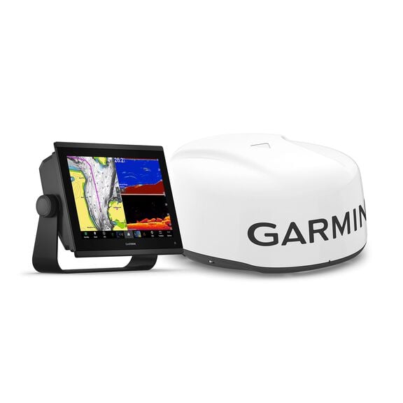
Garmin GPSMAP 1643xsv 16″ Chartplotter with Sonar and Garmin Navionics+ Mapping
€3,800.00

With its sleek design, powerful processing, and upgraded IPS display, the Garmin® GPSMAP® 1643xsv 16″ Chartplotter with Sonar and Garmin Navionics+™ Mapping integrates seamlessly into your Garmin marine system. This powerhouse Garmin chartplotter brings built-in Ultra High-Definition SideVü™ and ClearVü™ scanning sonars with vivid, high-contrast color palettes to help distinguish fish from structure. Pair with Panoptix™ or LiveScope™ easy-to-interpret live sonar (transducer not included) to see all around your boat in real time. The high-resolution 16″ IPS display offers improved sunlight readability and visibility from any angle. Experience unparalleled coverage and detail with built-in Garmin Navionics+ integrated coastal and inland mapping that includes Auto Guidance+™ technology. Get support and integration for your Force trolling motor (not included) to gain complete control while you fish. Sail and navigate with ease with SailAssist™ features. View laylines, race start line guidance, enhanced wind rose, heading and course-over-ground lines, true wind data fields and tide/current/time slider, wind angle, set and drift, wind speed, and more. Use the polar table to see key data, including how fast you should go at a certain wind angle and speed — so you know whether you need to adjust sail trim. If you have multiple compatible Garmin devices on your boat, you can share information among them, such as maps, user data, radar, IP camera video, and more. Connect to compatible autopilots, digital switching, weather, the Fusion audio system, media, VHF, AIS, and more from 1 screen. Built-in Wi-Fi® connectivity pairs with the free all-in-1 mobile ActiveCaptain app for access to the OneChart™ feature, smart notifications, software updates, Helm app, Garmin Quickdraw™ Community data, and more. Integrated ANT® technology lets you connect with some of your favorite devices, such as quatix® marine watches, gWind™ Wireless 2 transducers, GNX™ Wind marine instruments, and wireless remote controls. You can connect your chartplotter to different engines, including select Yamaha® engines, and get engine data right on your display. The OneHelm feature brings together all the operations and capabilities of select third-party devices, such as EmpirBus™ digital switching, on 1 screen. Pair your inReach satellite communicator (not included) to your chartplotter, and type custom messages by using the display’s on-screen keyboard. Access your contact list, or enter an email, inReach address, or phone number. You can also group messages by conversation for a texting-like appearance. The Garmin 1643sxv gives you the most dynamic and easy-to-use multifunction display you’ve ever experienced.
Manufacturer model #: 010-02919-03.
- Built-in Ultra High-Definition SideVü and ClearVü scanning sonars
- Vivid, high-contrast color palettes
- Compatible with Panoptix or LiveScope live sonar (transducer not included)
- High-resolution, 16″ IPS display
- Improved sunlight readability and visibility from any angle
- Built-in Garmin Navionics+ integrated coastal and inland mapping
- Auto Guidance+ technology
- Compatible with Force trolling motor (not included)
- SailAssist features: view laylines, race start line guidance, enhanced wind rose, heading and course-over-ground lines, and much more
- Built-in Wi-Fi connectivity
- Access to mobile ActiveCaptain app for OneChart feature, smart notifications, software updates, Helm app, Garmin Quickdraw Community data, and more
- Integrated ANT technology to connect with quatix marine watches, gWind Wireless 2 transducers, GNX Wind marine instruments, and wireless remote controls
- Compatible with select engines for onscreen engine data
- OneHelm feature to display operations and capabilities of select third-party devices on 1 screen
- Compatible with inReach satellite communicator (not included) for easy onscreen messaging
Specifications
| GPS Included | Yes |
| Model Number | 010-02919-03 |
| Pursuit | Freshwater Fishing |
Description
Garmin GPSMAP 1643xsv 16″ Chartplotter with Sonar and Garmin Navionics+ Mapping
Designed for modern mariners who expect clarity, confidence, and control on the water, the Garmin GPSMAP 1643xsv 16″ Chartplotter with Sonar and Garmin Navionics+ Mapping is positioned as a premium, all-in-one navigation and sonar solution. From offshore anglers and cruising enthusiasts to professional captains and serious weekend boaters, a smarter and more connected helm experience is consistently delivered.
Rather than relying on fragmented marine electronics, seamless integration is provided through a single, expansive 16-inch display. As a result, situational awareness is enhanced, decision-making is simplified, and time on the water is used more efficiently. Most importantly, confidence is reinforced at every stage of the journey—whether unfamiliar waters are being explored or trusted routes are being followed once again.
A New Standard for Marine Navigation Displays
At the heart of the Garmin GPSMAP 1643xsv, a large-format, high-resolution touchscreen display has been engineered to deliver exceptional readability in a wide range of marine conditions. Even under direct sunlight or in rapidly changing weather, chart details, sonar returns, and navigation data are clearly presented.
Because more screen space is made available, multiple data views can be displayed simultaneously. Consequently, charts, sonar, radar, and engine data can be monitored side by side without compromise. Instead of switching between screens, critical information is kept visible and accessible at all times.
Key Advantages of the 16-Inch Touchscreen Experience
-
Enhanced situational awareness is achieved through a wider viewing area
-
Reduced helm clutter is supported by consolidating multiple displays into one
-
Improved usability is enabled through intuitive touch controls
-
Longer viewing comfort is promoted during extended trips
By prioritizing clarity and usability, a display experience is delivered that feels both advanced and effortless.
Precision Navigation Powered by Garmin Navionics+ Mapping
Navigation accuracy is elevated through the inclusion of Garmin Navionics+ Mapping, which provides highly detailed marine charts that are continuously updated. Because both coastal and inland waters are covered, a broad range of boating activities is fully supported.
Depth contours, navigational aids, and points of interest are presented with impressive precision. As a result, safer routing decisions can be made, and unfamiliar waterways can be navigated with greater assurance. Additionally, daily chart updates ensure that newly reported changes are reflected, helping potential hazards to be avoided proactively.
Mapping Capabilities That Inspire Confidence
-
High-definition contour data is delivered for improved depth awareness
-
Frequent updates are provided to maintain chart accuracy
-
Coastal and inland coverage is included for versatile navigation
-
Smart routing assistance is supported to simplify trip planning
Through these mapping capabilities, time spent navigating is transformed into time spent enjoying the journey.
Integrated Sonar for Deeper Insight Below the Surface
In addition to advanced chartplotting, powerful sonar functionality is fully integrated into the Garmin GPSMAP 1643xsv. Because multiple sonar technologies are supported, underwater environments are revealed with remarkable detail.
Fish targets, structure, and bottom composition are clearly distinguished, allowing anglers to make informed decisions with confidence. Meanwhile, cruising and safety-focused users benefit from improved depth awareness and obstacle detection.
Sonar Technologies Designed for Versatility
-
Traditional CHIRP sonar is supported for accurate depth and target separation
-
Advanced scanning capabilities are enabled when compatible transducers are connected
-
Clear underwater imagery is delivered for better interpretation
-
Real-time data responsiveness is maintained for dynamic conditions
By combining navigation and sonar in one system, a unified view of both surface and subsurface conditions is consistently achieved.
Built for Integration at the Modern Helm
Rather than functioning as a standalone device, the Garmin GPSMAP 1643xsv has been designed to act as a central hub for marine electronics. Seamless integration with radar, autopilot, AIS, cameras, and engine systems is supported, creating a connected helm environment that adapts to individual needs.
Because compatibility across Garmin marine products is emphasized, system expansion can be achieved gradually. As boating requirements evolve, additional components can be added without requiring a complete overhaul.
Helm Integration Benefits
-
Reduced system complexity is achieved through centralized control
-
Future expandability is supported for long-term value
-
Consistent interface design is maintained across connected devices
-
Operational efficiency is improved through unified data access
Through thoughtful system design, the chartplotter becomes a long-term investment rather than a short-term upgrade.
Designed with Inclusive Usability in Mind
Ease of use has been prioritized so that boaters of all experience levels can feel confident at the helm. From first-time users to seasoned professionals, navigation and sonar tools are presented in an intuitive and approachable manner.
Touch gestures, customizable layouts, and clear menu structures are employed to reduce the learning curve. As a result, more time is spent navigating with assurance and less time is spent interpreting controls.
User-Focused Design Highlights
-
Customizable screen layouts are offered to suit individual preferences
-
Simple gesture controls are supported for quick interaction
-
Clear visual hierarchies are maintained for faster comprehension
-
Accessible design choices are implemented to support diverse users
By embracing inclusive design principles, the Garmin GPSMAP 1643xsv ensures that advanced marine technology remains approachable and empowering.
Why the Garmin GPSMAP 1643xsv Stands Apart
While many chartplotters promise advanced features, a carefully balanced combination of display size, processing power, sonar integration, and mapping accuracy sets this model apart. Instead of forcing compromises, a comprehensive solution is delivered that adapts to real-world boating demands.
Reliability, clarity, and scalability are consistently emphasized. Therefore, whether long offshore passages are planned or short recreational outings are enjoyed, dependable performance is always within reach.

Advanced Networking and Seamless Marine Connectivity
Rather than operating in isolation, the Garmin GPSMAP 1643xsv 16″ Chartplotter with Sonar and Garmin Navionics+ Mapping has been engineered to function as the central intelligence of a fully networked helm. Through advanced networking capabilities, data from multiple onboard systems is unified into one coherent interface.
Because Ethernet and NMEA connectivity are supported, information from radar, sonar modules, AIS, autopilot systems, cameras, and engine monitoring devices is shared effortlessly. As a result, situational awareness is expanded, and operational confidence is significantly reinforced.
Networking Capabilities That Elevate Control
-
High-speed Ethernet networking is enabled for rapid data sharing
-
NMEA 2000® and NMEA 0183® compatibility is supported for broad system integration
-
Multiple displays synchronization is allowed for larger helm setups
-
Centralized command functionality is delivered for simplified operation
Through this level of connectivity, a helm environment is created where every system works together rather than competing for attention.
Real-Time Radar and AIS Awareness for Safer Navigation
Safety on the water is strengthened through seamless radar and AIS integration. When compatible radar systems are connected, real-time target tracking is presented directly on the chartplotter display. Consequently, vessels, weather formations, and potential obstacles are identified with greater clarity.
AIS data is overlaid onto navigation charts, ensuring that nearby vessel information is clearly communicated. Therefore, collision avoidance is enhanced, especially in busy waterways or reduced-visibility conditions.
Safety-Oriented Awareness Features
-
Real-time radar overlays are displayed on navigation charts
-
AIS target identification is clearly presented for nearby vessels
-
Improved low-visibility navigation is supported
-
Enhanced decision-making confidence is encouraged
By prioritizing awareness and clarity, navigation risks are reduced, and peace of mind is consistently promoted.
Autopilot Integration for Effortless Long-Distance Travel
Long passages and complex routes are made more manageable through full autopilot integration. Once connected, routes created on the chartplotter can be followed automatically, allowing course corrections to be handled with precision.
Because autopilot control is accessed directly from the chartplotter interface, manual adjustments are simplified. As a result, fatigue is reduced, and focus can be maintained on broader situational awareness.
Autopilot Control Advantages
-
Route-following accuracy is improved
-
Manual override controls are easily accessed
-
Consistent steering performance is maintained
-
Long-distance comfort is significantly enhanced
Through intelligent automation, time on the water becomes more enjoyable and less demanding.
High-Performance Processing for Instant Responsiveness
Performance expectations are exceeded through a powerful internal processor designed to handle complex marine data streams. Chart redraws, sonar returns, and networked information are rendered smoothly, even when multiple functions are displayed simultaneously.
Because lag and delay are minimized, confidence in real-time data is preserved. Consequently, decisions are made faster and with greater certainty.
Comprehensive Feature Breakdown for Informed Buying Decisions
Buying confidence is strengthened when features are clearly understood. For that reason, the Garmin GPSMAP 1643xsv 16″ Chartplotter with Sonar and Garmin Navionics+ Mapping has been designed with a feature set that directly addresses real-world boating needs. Rather than focusing on technical jargon alone, practical benefits are consistently emphasized.
Because every feature is purpose-driven, functionality is translated into meaningful on-the-water advantages. As a result, informed decisions are supported at every stage of the buying journey.
Core Feature Highlights at a Glance
-
16-inch high-resolution touchscreen display is provided for maximum visibility
-
Integrated sonar support is included for underwater awareness
-
Garmin Navionics+ Mapping is bundled for detailed navigation
-
High-speed networking capabilities are enabled for system expansion
-
Advanced processing performance is delivered for smooth operation
By presenting essential capabilities clearly, product value becomes immediately apparent.
Feature-to-Benefit Mapping That Converts Interest into Action
Features alone rarely drive purchasing decisions. Therefore, each core capability of the Garmin GPSMAP 1643xsv has been aligned with a tangible benefit that improves time spent on the water.
Because benefits are framed from the user’s perspective, confidence in long-term satisfaction is reinforced. Consequently, hesitation is reduced, and commitment becomes easier.
How Key Features Translate into Real Benefits
-
Large-format display → Improved situational awareness and reduced eye strain
-
Integrated sonar technologies → Faster fish location and safer depth monitoring
-
Navionics+ chart coverage → More accurate routing and hazard avoidance
-
System networking → A cleaner, more efficient helm layout
-
Powerful processing → Immediate access to critical data without delays
Through this alignment, the value proposition is communicated clearly and persuasively.
Built to Support Multiple Boating Lifestyles
No two boating experiences are identical. That reality has been reflected in the flexible design of the Garmin GPSMAP 1643xsv. Whether fishing, cruising, or offshore navigating is prioritized, adaptable functionality is consistently delivered.
Because personalization options are extensive, the system is shaped around individual preferences rather than imposing a rigid workflow.
Use-Case Scenarios That Highlight Versatility
-
Recreational anglers are supported through precise sonar and waypoint tools
-
Cruisers and explorers benefit from detailed charts and route planning
-
Offshore operators rely on radar, AIS, and autopilot integration
-
Family boaters enjoy safer and more intuitive navigation
By accommodating diverse needs, inclusivity and flexibility are reinforced.
Comparison Positioning Without Compromise
When compared to smaller or less integrated chartplotters, clear distinctions emerge. Instead of juggling multiple displays or outdated mapping solutions, a single, expansive platform is provided.
Because advanced features are consolidated into one interface, operational efficiency is enhanced. As a result, the overall experience feels both streamlined and premium.
Competitive Differentiators Worth Noting
-
Larger display size reduces the need for secondary screens
-
Bundled premium mapping lowers additional upgrade costs
-
Broad compatibility ecosystem supports long-term expansion
-
Refined user interface minimizes learning curves
Through these differentiators, the Garmin GPSMAP 1643xsv is positioned as a future-ready solution rather than a short-term fix.
Designed to Reduce Buyer Risk and Increase Satisfaction
Purchasing marine electronics often involves uncertainty. To address that concern, reliability, brand reputation, and long-term support have been emphasized throughout the design and ownership experience.
Because consistent software updates and wide dealer support are provided, confidence in ongoing performance is strengthened. Therefore, buyers are reassured that support will remain available long after installation.
Buyer Reassurance Factors
-
Established marine technology expertise is represented by the Garmin brand
-
Ongoing software enhancements are regularly delivered
-
Strong customer support networks are widely available
-
Proven reliability track record is consistently demonstrated
By reducing perceived risk, trust is built and purchasing confidence is encouraged.
Installation Flexibility and Helm Optimization
Installation challenges are minimized through thoughtful hardware and software design. Whether flush-mounted or integrated into a multi-display helm, compatibility is maintained.
Because wiring standards and mounting options are well-documented, professional installation or knowledgeable DIY setups are both supported. As a result, integration is smoother and downtime is reduced.
Installation and Setup Benefits
-
Flexible mounting options are available
-
Standardized connectivity ports simplify integration
-
Clear configuration menus speed up initial setup
-
Expandable system architecture allows future upgrades
Through installation-friendly design, time-to-enjoyment is shortened.
Performance Enhancements That Matter
-
Fast chart rendering is consistently delivered
-
Smooth multitasking is supported across functions
-
Reduced latency is maintained during data-heavy operations
-
Reliable responsiveness is ensured in demanding environments
By eliminating performance bottlenecks, a fluid and dependable user experience is sustained.
Optimized for Fishing Excellence Without Compromise
For anglers, the Garmin GPSMAP 1643xsv has been designed to function as a strategic advantage rather than a simple display. Detailed sonar imagery, waypoint precision, and advanced mapping work together to support more informed fishing decisions.
Because structure, bait, and fish targets are clearly distinguished, time spent searching is reduced. Instead, effort is focused where opportunities are most likely to be found.
Fishing-Focused Advantages
-
Precise waypoint marking is enabled for productive locations
-
Clear target separation is delivered through advanced sonar
-
Efficient area coverage is supported by detailed mapping
-
Repeatable success patterns are easier to establish
By combining technology with usability, fishing efficiency is elevated without increasing complexity.
Designed for Confident Cruising and Exploration
Beyond fishing applications, cruising and exploration are equally supported. Long-range planning tools, detailed charts, and integrated system monitoring ensure that voyages are conducted with confidence and clarity.
Because engine data and system status can be monitored directly from the chartplotter, potential issues are identified early. As a result, smoother and more predictable journeys are consistently achieved.
Cruising and Exploration Benefits
-
Accurate route planning is simplified through smart mapping
-
Engine and system monitoring is centrally displayed
-
Reduced workload at the helm is encouraged
-
Enhanced voyage confidence is consistently delivered
Through thoughtful design, every journey—short or long—is approached with assurance.
Built for Offshore Reliability and Long-Term Value
Marine environments demand durability, and the Garmin GPSMAP 1643xsv has been constructed to meet those expectations. Materials, internal components, and software stability are all optimized for long-term reliability in challenging conditions.
Because system expandability is supported, the chartplotter continues to deliver value as boating needs evolve. Therefore, it remains relevant not only today but well into the future.salt water fishing poles
Long-Term Ownership Advantages
-
Proven marine-grade construction is utilized
-
Software updates are continuously provided
-
Expandable system architecture is maintained
-
Strong resale value is supported through brand reliability
By focusing on longevity, the investment is protected across seasons and adventures.
Frequently Asked Questions (FAQ)
What is the Garmin GPSMAP 1643xsv primarily used for?
The Garmin GPSMAP 1643xsv 16″ Chartplotter with Sonar and Garmin Navionics+ Mapping is designed to support advanced marine navigation, sonar interpretation, and helm system integration. It is commonly used for fishing, cruising, offshore navigation, and long-distance route planning. Because multiple marine functions are combined into one interface, overall efficiency at the helm is significantly improved.ocean fishing rods
Is Garmin Navionics+ Mapping included with the chartplotter?
Yes, Garmin Navionics+ Mapping is included. Highly detailed coastal and inland charts are provided, along with frequent updates. As a result, navigation accuracy is maintained, and newly identified hazards or chart corrections are reflected over time without requiring separate purchases.ocean fishing rods
What type of sonar is supported by the GPSMAP 1643xsv?
Multiple sonar technologies are supported, including traditional CHIRP sonar. Additionally, compatibility with advanced scanning sonar technologies is provided when appropriate transducers are connected. Because flexibility is emphasized, the system can be adapted to different fishing styles and depth conditions.
Can the Garmin GPSMAP 1643xsv be networked with other marine electronics?
Yes, extensive networking capabilities are supported. Through Ethernet and NMEA connectivity, integration with radar, autopilot systems, AIS, cameras, engine monitoring, and additional displays is enabled. Consequently, the chartplotter can function as the central control hub of a fully connected helm.
Is the 16-inch display suitable for direct sunlight?
The 16-inch touchscreen display has been engineered for marine environments where sunlight exposure is common. High brightness and clarity are delivered, ensuring that charts, sonar data, and navigation details remain readable even in challenging lighting conditions.
Can multiple data views be displayed at the same time?
Yes, split-screen and multi-window viewing are supported. Because of the large screen size, charts, sonar, radar, and other data sources can be viewed simultaneously. As a result, critical information is kept visible without constant screen switching.
Is autopilot control available through this chartplotter?
Autopilot integration is fully supported when a compatible system is connected. Routes created on the chartplotter can be followed automatically, and steering adjustments can be made directly from the display. Therefore, long-distance travel is made more comfortable and less demanding.
Who is this chartplotter best suited for?
The Garmin GPSMAP 1643xsv is suited for a wide range of users, including recreational anglers, offshore captains, cruising enthusiasts, and family boaters. Because inclusive design principles are applied, both experienced operators and newer users are supported without unnecessary complexity.
How difficult is installation?
Installation complexity is reduced through standardized mounting options and well-documented connectivity. Both professional installation and knowledgeable DIY setups are supported. As a result, integration into existing helm systems is generally straightforward.
Are software updates provided over time?
Yes, ongoing software updates are regularly provided. Performance improvements, feature enhancements, and compatibility updates are delivered to ensure long-term reliability. Consequently, the chartplotter remains current as marine technology continues to evolve.
Does the GPSMAP 1643xsv support future expansion?
Future expansion is fully supported. Additional displays, sensors, radar, sonar modules, and accessories can be added as needs change. Because scalability is prioritized, the system is positioned as a long-term investment rather than a short-term solution.
Why should this model be chosen over smaller chartplotters?
A larger display, integrated premium mapping, advanced processing power, and broad networking capabilities distinguish this model from smaller alternatives. Instead of managing multiple screens or limited features, a consolidated and more efficient helm experience is delivered.
Additional information
| GPS Included: | Yes |
|---|
Related products
-

Humminbird HELIX 10 CHIRP MEGA SI GPS G4N Fish Finder/Chartplotter
€700.00Select options This product has multiple variants. The options may be chosen on the product page -
Humminbird XPLORE 12 CMSI+ CHIRP MEGA SI Fish Finder/Chartplotter
€2,000.00Select options This product has multiple variants. The options may be chosen on the product page -
-
Lowrance Elite FS 12 Fish Finder/Chartplotter with TotalScan Transducer
€819.00Select options This product has multiple variants. The options may be chosen on the product page
Reviews
There are no reviews yet.