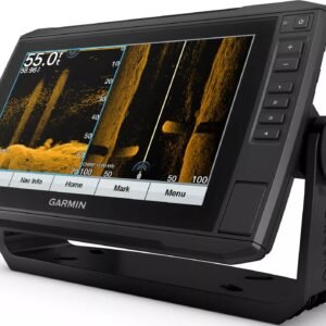
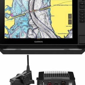
Garmin GPSMAP Touch Screen Fish Finder/Chart Plotter Combo with Mapping and Sonar
Price range: €2,000.00 through €3,075.00

Easily powerful. Powerfully easy. The Garmin® GPSMAP® Touch-Screen Fish Finder/Chart Plotter Combo with Mapping and Sonar offers superior clarity and fish-finding power with intuitive controls for total command of your boating and angling. The full HD IPS display offers wider viewing angles, outstanding clarity, and sunlight readability, even with polarized sunglasses. Built-in support for 1kW Dual-Channel CHIRP traditional sonar provides superior target separation, while ClearVü and SideVü scanning sonars let you see up to 1,000′ below and around your boat at 260kHz (transducers not included). Pair your chartplotter with Garmin live sonar support to see all around your boat in real time. Gamin SailAssist™ lets you view laylines, race start line guidance, enhanced wind rose, heading and course-over-ground lines, true wind data fields, and tide/current/time slider, wind angle, set and drift, wind speed, polars, and more. Experience unparalleled coverage and detail with built-in Garmin Navionics+™ integrated coastal and inland mapping that includes Auto Guidance+™ technology and a 1-year subscription for downloadable daily updates and more on select chartplotters. Use the polar table to see key data, including how fast you should go at a certain wind angle and speed, so you know whether you need to adjust sail trim. If you have multiple compatible Garmin devices on your boat, you can share information among them, such as maps, user data, radar, and IP cameras. NMEA 2000® and NMEA 0183 network support lets you connect to autopilots, digital switching, weather, FUSION-Link™ audio system, media, VHF, AIS, and more from a single screen. Built-in Wi-Fi® connectivity pairs with the free all-in-1 ActiveCaptain™ mobile app for access to the OneChart™ feature, smart notifications , software updates, Helm, Garmin Quickdraw™ Community data, and more. Integrated Bluetooth® and ANT wireless technologies connect with some of your favorite devices, such as quatix® marine watches, gWind™ Wireless 2 transducers, GNX™ Wind marine instruments, and wireless remote controls. The OneHelm™ feature brings together all the operations and capabilities of third-party devices, such as EmpirBus™ digital switching, on 1 screen. SmartMode™ controls give you quick, 1-touch access to the information you need to ease high-stress situations such as docking. You can incorporate networked sonar, radar, cameras, media, and more. By networking select Garmin chartplotters with a Force® trolling motor and your compatible Power-Pole® shallow-water anchoring system, you can access advanced boat control features from your plotter, including smart anchor auto-deployment, smart anchor jog, auto stow, anchor drag detection and auto guidance end-of-route anchoring. Spend more time fishing, less time positioning. The Garmin GPSMAP Touch-Screen Fish Finder/Chartplotter Combo checks every box and gives you more power than you ever imagined to take your time on the water to the next level.
- Full HD IPS display with exceptional viewing angles, clarity, and sunlight readability
- Built-in support for 1kW Dual-Channel CHIRP traditional sonar and ClearVü and SideVü scanning sonars (transducers not included)
- SailAssist sailboat-focused feature suite
- Garmin Navionics+ integrated coastal and inland mapping
- Auto Guidance+ technology
- 1-year subscription for downloadable daily updates
- NMEA 2000 and NMEA 0183 network support
- Built-in Wi-Fi
- Access to all-in-1 ActiveCaptain mobile app
- Integrated Bluetooth and ANT wireless technologies
- OneHelm third-party device integration
- SmartMode 1-touch information access
- Power-Pole shallow-water anchoring system compatibility
Description
Garmin GPSMAP Touch Screen Fish Finder/Chart Plotter Combo with Mapping and Sonar
Advanced Marine Navigation and Fish-Finding Technology Designed for Precision, Confidence, and Inclusivity on the Water
Introduction to a New Standard in Marine Electronics
Modern marine navigation and fish-finding challenges are increasingly being solved through integrated, intelligent technology. As a result, the Garmin GPSMAP Touch Screen Fish Finder/Chart Plotter Combo with Mapping and Sonar has been positioned as a trusted solution for anglers, boaters, and navigation professionals who require accuracy, clarity, and reliability in every environment.
Through advanced sonar processing, intuitive touchscreen controls, and industry-leading cartography, a seamless on-water experience is delivered. Moreover, both recreational and professional users are supported through inclusive design choices that prioritize ease of use, adaptability, and real-world performance.
Because performance expectations continue to rise, marine electronics are no longer evaluated solely on features. Instead, value is measured through confidence, efficiency, and long-term usability. Therefore, the Garmin GPSMAP Touch Screen Fish Finder/Chart Plotter Combo with Mapping and Sonar has been engineered to exceed expectations across all these dimensions.
Why the Garmin GPSMAP Touch Screen Fish Finder/Chart Plotter Combo with Mapping and Sonar Stands Out
A crowded marine electronics market has made informed decision-making more important than ever. Consequently, differentiation is achieved through thoughtful integration rather than feature overload. With this in mind, Garmin’s GPSMAP series has been developed to balance power with accessibility.
By combining high-resolution mapping, responsive touchscreen interaction, and multiple sonar technologies, a unified system has been created. As a result, time spent navigating menus is reduced, while time spent focusing on fishing, exploration, and safety is increased.
Additionally, a future-ready platform has been provided, allowing software updates, chart upgrades, and accessory integrations to be added as needs evolve.
Touch Screen Technology Designed for Real-World Conditions
Intuitive Control Through Advanced Touchscreen Engineering
Precision interaction has been made possible through a sunlight-readable, high-resolution touchscreen. Unlike traditional button-only systems, commands are executed through intuitive gestures such as tapping, pinching, and swiping. Therefore, rapid adjustments can be made even in dynamic marine conditions.
Furthermore, responsiveness has been optimized for wet and gloved hands, ensuring consistent usability across weather scenarios. Because safety and speed are critical on the water, menu navigation has been streamlined to reduce distraction.
Enhanced Visibility in All Lighting Environments
Clarity is maintained through anti-glare coatings and high-brightness displays. As a result, information remains readable during early mornings, bright afternoons, and low-light returns. Moreover, customizable display settings allow contrast, color palettes, and layouts to be adjusted according to personal preference and accessibility needs.
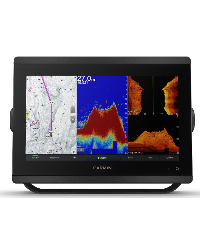
Integrated Chart Plotter Capabilities for Confident Navigation
High-Accuracy GPS and Chart Plotting
Navigation accuracy has been enhanced through multi-GNSS support, allowing satellite signals to be received from multiple global systems. Consequently, positioning accuracy is improved even in challenging coastal or offshore environments.
Routes, waypoints, and tracks are easily created and managed. Because hazards, channels, and points of interest are clearly visualized, informed navigation decisions are consistently supported.
Industry-Leading Mapping Support
Compatibility with Garmin’s premium mapping solutions ensures that detailed marine cartography is always within reach. Therefore, depth contours, navigation aids, and shoreline details are displayed with exceptional precision.
Supported mapping options typically include:
-
Garmin Navionics+™
-
Garmin Navionics Vision+™
-
BlueChart® g3 and g3 Vision
As a result, both inland and offshore waters can be navigated with confidence, regardless of location or experience level.
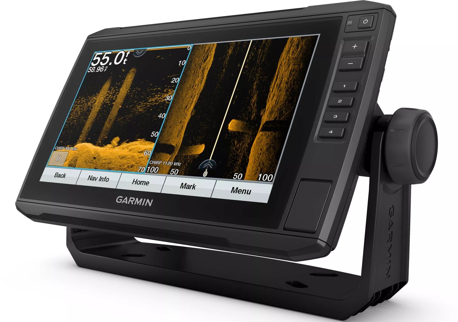
Advanced Sonar Technology for Superior Fish Detection
ClearVü™ and SideVü™ Sonar Explained
Fish identification has been dramatically improved through high-frequency sonar technologies. Instead of interpreting vague sonar arches, near-photographic clarity is delivered beneath and around the vessel.
Because of this advancement:
-
Structure is clearly defined
-
Fish separation is enhanced
-
Bottom composition is easily identified
Therefore, less guesswork is required, and fishing strategies can be adjusted with precision.
Traditional CHIRP Sonar Performance
In addition to scanning sonar, traditional CHIRP sonar is supported. Through continuous frequency modulation, target separation and depth penetration are improved. Consequently, both shallow and deep-water performance is optimized.
This balanced sonar approach ensures that diverse fishing styles and environments are fully supported.
Key Benefits of the Garmin GPSMAP Touch Screen Fish Finder/Chart Plotter Combo with Mapping and Sonar
Highlighted Product Advantages
-
Integrated fish finder and chart plotter combo for streamlined marine electronics setup
-
High-resolution touchscreen display designed for sunlight visibility and wet conditions
-
Advanced sonar technologies including ClearVü™, SideVü™, and CHIRP sonar
-
Comprehensive mapping compatibility with Garmin’s premium cartography solutions
-
Inclusive interface design supporting users of all experience levels
-
Expandable system architecture for future upgrades and accessories
Because all critical systems are combined into one intuitive platform, onboard complexity is significantly reduced.
Designed for a Wide Range of Users and Applications
Inclusive Design for All Experience Levels
Marine technology should empower, not intimidate. Therefore, the Garmin GPSMAP Touch Screen Fish Finder/Chart Plotter Combo with Mapping and Sonar has been designed with inclusivity in mind.
Whether first-time boaters or seasoned professionals are being supported, onboarding is simplified through guided menus, customizable layouts, and clear visual cues. As a result, confidence is built quickly, and long-term satisfaction is encouraged.
Versatility Across Fishing and Boating Styles
This system has been widely adopted across multiple applications, including:
-
Freshwater fishing
-
Saltwater angling
-
Offshore navigation
-
Coastal cruising
-
Professional guiding and charter operations
Because adaptability has been prioritized, a single investment can support evolving needs over time.
Performance, Reliability, and Long-Term Value
Built to Garmin’s Proven Quality Standards
Durability has been ensured through marine-grade materials and rigorous testing. As a result, consistent performance is maintained in harsh saltwater environments, extreme temperatures, and continuous vibration conditions.
Moreover, Garmin’s reputation for long-term software support ensures that features and performance continue to improve after purchase.
A Smart Investment in Confidence on the Water
Rather than being positioned as a short-term upgrade, the Garmin GPSMAP Touch Screen Fish Finder/Chart Plotter Combo with Mapping and Sonar has been designed as a foundational marine system. Therefore, reliability, expandability, and future compatibility have all been emphasized.
Advanced Sonar Modes and Real-World Fishing Applications
How Multi-Sonar Integration Enhances Fishing Success
Fishing outcomes are increasingly being influenced by the quality of underwater intelligence available. Therefore, multiple sonar technologies have been integrated into the Garmin GPSMAP Touch Screen Fish Finder/Chart Plotter Combo with Mapping and Sonar to ensure adaptable performance across environments.
Rather than relying on a single sonar view, layered data interpretation is enabled. As a result, informed decisions are supported through cross-referenced depth, structure, and fish activity data.
Because clarity is prioritized, visual noise is minimized while meaningful targets are emphasized.
ClearVü™ Sonar for Near-Photographic Downward Views
ClearVü™ sonar technology has been engineered to deliver high-frequency, downward-facing images that closely resemble photographic representations of underwater environments. Consequently, submerged structure such as rocks, vegetation, and wrecks is presented with exceptional definition.
By using ClearVü™ sonar:
-
Fish can be differentiated from structure with greater confidence
-
Bottom transitions are identified more easily
-
Drop-offs and ledges are visually confirmed
Therefore, time spent interpreting ambiguous sonar returns is significantly reduced.
SideVü™ Sonar for Wide-Area Scanning Efficiency
While traditional sonar focuses beneath the vessel, SideVü™ sonar extends visibility to both sides. Because of this expanded field of view, large areas can be scanned quickly without multiple passes.
As a result:
-
Search time is reduced
-
Productive zones are identified faster
-
Boat positioning is optimized for precise casting
SideVü™ sonar has been especially valued by anglers targeting structure-oriented species in expansive waters.
Traditional CHIRP Sonar for Depth and Target Separation
In addition to scanning sonar, traditional CHIRP sonar provides continuous frequency modulation. Through this process, target separation is enhanced while depth penetration is maintained.
Because multiple frequencies are transmitted simultaneously, individual fish targets are more clearly separated from surrounding debris. Therefore, both shallow flats and deep channels can be explored with confidence.
Mapping Layers, Contour Detail, and Route Planning Precision
Advanced Cartography That Supports Safer Navigation
High-quality mapping has been recognized as essential for both fishing efficiency and navigation safety. Consequently, the Garmin GPSMAP Touch Screen Fish Finder/Chart Plotter Combo with Mapping and Sonar supports advanced cartographic solutions designed for precision.
Depth contours, navigation aids, and shoreline features are displayed with exceptional clarity. As a result, hazards are avoided more easily, and routes are planned with confidence.
Detailed Contour Mapping for Strategic Fishing
High-definition contour lines have been included to reveal subtle bottom changes. Because fish behavior is often influenced by depth variation, this information is critical.
Through contour-rich maps:
-
Breaklines are identified quickly
-
Channels and humps are visualized clearly
-
Seasonal fish movement patterns are better understood
Therefore, fishing strategies can be adjusted proactively rather than reactively.
Route Creation and Waypoint Management
Navigation efficiency has been enhanced through intuitive route and waypoint management tools. Instead of complex menu navigation, routes are created through simple touch interactions.
Because waypoints can be labeled, color-coded, and organized, valuable locations are preserved for future trips. Moreover, track recording ensures that productive paths are easily retraced.
Fishing Strategies Enhanced by GPSMAP Technology
Data-Driven Decision Making on the Water
Modern fishing success is increasingly data-driven. Therefore, the integration of sonar, GPS, and mapping within a single display provides a unified decision-making platform.
By combining real-time sonar returns with mapped structure, fishing patterns are identified more efficiently. As a result, adjustments are made quickly, and wasted effort is minimized.
Seasonal and Species-Specific Applications
The versatility of the Garmin GPSMAP Touch Screen Fish Finder/Chart Plotter Combo with Mapping and Sonar allows it to support a wide range of fishing styles and seasonal conditions.
Common applications include:
-
Spring shallow-water pattern identification
-
Summer thermocline tracking
-
Fall structure-based fishing strategies
-
Winter depth monitoring and safety navigation
Because adaptability has been prioritized, year-round performance is consistently supported.
Customization, Accessibility, and User-Focused Design
Personalized Display Layouts for Improved Usability
Every angler and boater interacts with information differently. Therefore, customizable screen layouts have been provided.
Split-screen views, adjustable data overlays, and personalized color schemes allow the display to be tailored to individual preferences. As a result, critical information is always presented clearly and efficiently.
Accessibility-Focused Interface Design
Inclusive design principles have been applied throughout the system. Because users may have varying levels of experience or visual needs, menu structures have been simplified.
Key accessibility considerations include:
-
High-contrast display options
-
Scalable text and icons
-
Simplified navigation pathways
Consequently, confidence is built quickly for new users while efficiency is maintained for experienced operators.
Highlighted Use-Case Benefits for Product Listings
Why Anglers and Boaters Choose This Garmin GPSMAP Combo
-
Multi-sonar integration supporting diverse fishing environments
-
High-definition mapping for safer, more confident navigation
-
Touchscreen-based route planning for fast adjustments
-
Customizable layouts for personalized user experiences
-
Inclusive interface design accommodating all skill levels
Because both performance and usability are balanced, long-term satisfaction is consistently achieved.
Reliability, Software Support, and System Longevity
Continuous Improvement Through Software Updates
Garmin’s ecosystem has been designed to evolve. Therefore, software updates are regularly provided to enhance performance, expand features, and improve compatibility.
As a result, the system remains current without requiring frequent hardware replacements.
Designed for Long-Term Marine Use
Marine-grade construction ensures that reliability is maintained in demanding conditions. Because corrosion resistance and vibration tolerance have been prioritized, dependable operation is consistently delivered.
Networking, System Expansion, and Seamless Integration
A Scalable Marine Electronics Ecosystem
Marine technology requirements often evolve over time. Therefore, the Garmin GPSMAP Touch Screen Fish Finder/Chart Plotter Combo with Mapping and Sonar has been engineered as a scalable platform rather than a fixed solution.
Through built-in networking capabilities, multiple compatible devices can be connected. As a result, data sharing across displays, sensors, and accessories is streamlined, while system redundancy is improved.
Because future expansion has been anticipated, long-term value is significantly increased.
NMEA 2000® and NMEA 0183 Connectivity Explained
Industry-standard networking protocols have been supported to ensure broad compatibility. Consequently, the GPSMAP system integrates smoothly with a wide range of marine electronics.
Supported network connections typically allow integration with:
-
Engine data and fuel monitoring systems
-
AIS (Automatic Identification System) transceivers
-
Autopilot systems
-
VHF radios with DSC functionality
-
Wind, depth, and environmental sensors
As a result, a centralized command hub is created, reducing the need for multiple standalone displays.
Wireless Connectivity and Smart Device Integration
Modern convenience has been addressed through built-in wireless capabilities. Therefore, smartphones and tablets can be paired for enhanced control and data sharing.
Through compatible mobile applications:
-
Waypoints can be created and transferred remotely
-
Software updates are managed efficiently
-
Notifications are mirrored on the display
Because mobility and flexibility are supported, pre-trip planning and post-trip review are simplified.
Transducer Compatibility and Sonar Expansion Options
Flexible Transducer Support for Customized Performance
Different fishing styles and water conditions require different sonar configurations. Therefore, broad transducer compatibility has been provided.
Compatible options often include:
-
Transom-mount transducers
-
Thru-hull transducers
-
In-hull transducers
-
High-performance scanning transducers
Because transducer selection influences sonar performance significantly, users are empowered to choose solutions that align with their specific needs.
High-Power Sonar and Professional-Grade Upgrades
For advanced users, support for higher-power sonar modules ensures deeper water penetration and enhanced clarity. As a result, offshore and deep-water environments are navigated with confidence.
This flexibility allows recreational systems to be gradually upgraded into professional-grade installations without full replacement.
Installation Guidance and Setup Considerations
Simplified Installation for New and Existing Vessels
Installation complexity has been reduced through thoughtful design. Consequently, both new installations and retrofits are supported efficiently.
Because mounting hardware and clear documentation are typically provided, setup time is minimized. Moreover, touchscreen calibration and initial configuration are guided through on-screen prompts.
Flush Mount and Bail Mount Options
Multiple mounting styles have been supported to accommodate different helm layouts.
Common mounting options include:
-
Flush mounting for a clean, integrated helm appearance
-
Bail mounting for flexible positioning and angle adjustment
As a result, ergonomic visibility and access are optimized regardless of vessel size.
Power Management and Electrical Considerations
Stable power delivery is essential for reliable marine electronics. Therefore, voltage tolerance and efficient power consumption have been prioritized.
Because clear wiring guidelines are provided, electrical system integration is simplified, reducing the risk of interference or performance issues.
Professional, Offshore, and Commercial Use Cases
Trusted Performance for Professional Applications
Reliability expectations are significantly higher in professional environments. Consequently, the Garmin GPSMAP Touch Screen Fish Finder/Chart Plotter Combo with Mapping and Sonar has been widely adopted by charter operators, guides, and commercial users.
Because consistent accuracy and durability are delivered, operational efficiency is improved while downtime is minimized.
Offshore Navigation and Safety Enhancements
Offshore environments demand precision and redundancy. Therefore, advanced navigation features such as detailed charting, AIS integration, and waypoint management play a critical role.
Through these capabilities:
-
Vessel traffic is monitored effectively
-
Safe routes are maintained
-
Emergency response readiness is improved
As a result, confidence is sustained even in challenging conditions.
Multi-Display Helm Configurations
Larger vessels often require multiple displays. Because network sharing is supported, several GPSMAP units can be synchronized.
This allows:
-
Dedicated navigation screens
-
Dedicated sonar screens
-
Redundant system access
Therefore, situational awareness is enhanced across the helm.
Highlighted Product Expansion Benefits for Listings
Why This System Grows With You
-
Expandable networking architecture for future accessories
-
Broad transducer compatibility for tailored sonar performance
-
Wireless connectivity for modern planning and control
-
Professional-grade reliability trusted in offshore conditions
-
Flexible installation options for diverse vessel layouts
Because adaptability is built into the system, long-term ownership satisfaction is maximized.
Buying Considerations and Long-Term Value Perspective
A Smarter Alternative to Fragmented Systems
Instead of managing multiple independent devices, a unified system is provided. As a result, learning curves are reduced, and operational efficiency is increased.
Because upgrades are modular, initial investment remains protected as needs change.
Warranty, Support, and Brand Confidence
Garmin’s global support infrastructure ensures that assistance, updates, and documentation remain accessible. Therefore, confidence extends beyond the purchase itself.
Additional information
| Screen Size: | 10 inches, 12 inches |
|---|---|
| Color: | Black |
| GPS Included | Yes |
| Transducer Model: | None |
Related products
-
Lowrance Elite FS 12 Fish Finder/Chartplotter with TotalScan Transducer
€819.00Select options This product has multiple variants. The options may be chosen on the product page -
-

Garmin ECHOMAP UHD2 93sv 9″ Fish Finder/Chartplotter with GT56UHD-TM Transducer and Garmin Navionics+ US Inland Mapping
€900.00Select options This product has multiple variants. The options may be chosen on the product page -
Garmin STRIKER Vivid 7 Series Fish Finder
€340.00Select options This product has multiple variants. The options may be chosen on the product page
Reviews
There are no reviews yet.