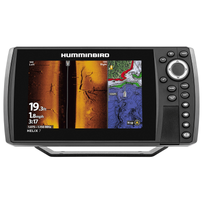
Humminbird HELIX 7 CHIRP SI GPS G4 Fish Finder/Chartplotter – G4
€416.00
The Humminbird® HELIX 7 CHIRP SI GPS G4 Fish Finder/Chartplotter puts every detail of the underwater world right at your fingertips. This robust Humminbird fish finder sports a spacious, vivid 7″ display so you can easily view all the powerful technologies. Dual Spectrum CHIRP provides long, well-defined fish arches and a clear view of fish-holding structure and the bottom, with 2 ways to search: wide mode for maximum coverage and narrow mode for maximum detail. The built-in Humminbird Basemap provides you a clear view of underwater terrain and surrounding points of interest so you can fish and navigate with total confidence. Identify buoys, day markers, hazards, marinas, contours, depth markers, and much, much more. Includes charts of more than 10,000 lakes, plus U.S. coastal coverage. Compatibility with Humminbird LakeMaster® and CoastMaster™ charts, as well as your choice of compatible Navionics® charts, lets you get a complete view of the world below. AutoChart Live creates real-time maps of your fishing spots, with access to patented Humminbird LakeMaster features. Map depth contours, bottom hardness, and vegetation as you drive your boat. Includes Low-Q CHIRP transducer, power cable, gimbal mounting bracket, and mounting hardware. Mfrs. 1-year limited warranty.
- Powerhouse Humminbird HELIX fish finder
- Vivid, 7″ display
- Dual Spectrum CHIRP
- Built-in Humminbird Basemap of charts and maps of more than 10,000 lakes
- AutoChart Live real-time mapping
Specifications
| Sonar Type | 2D/Down Scanning/Side Scanning |
| Screen Size | 7 inches |
| Transducer Model | XNT 9 HW SI T |
| GPS Included | Yes |
| Product Color | Black |
| Amp Draw | .8 |
| Map/Chart Type | US Freshwater/Saltwater |
| Model Number | 411920-1 |
| Pursuit | Freshwater Fishi |
Description
Humminbird HELIX 7 CHIRP SI GPS G4
Modern anglers demand clarity, confidence, and control on the water. For that reason, the Humminbird HELIX 7 CHIRP SI GPS G4 Fish Finder/Chartplotter – G4 has been engineered to deliver a decisive advantage in both freshwater and coastal environments.
Instead of relying on guesswork, informed decisions are enabled through advanced sonar imaging, responsive GPS navigation, and a refined user interface designed for efficiency. As a result, every outing becomes more productive, more engaging, and more rewarding.
Designed for Anglers Who Expect More
Performance expectations continue to rise across the fishing community. Consequently, technology must evolve to keep pace. With this in mind, the HELIX 7 G4 platform was developed to serve anglers who value precision without unnecessary complexity.
Whether structure fishing, trolling expansive flats, or navigating unfamiliar waters, confidence is reinforced through reliable data presentation and intuitive controls.
Advanced CHIRP Sonar Technology Explained
Clearer Targets Through Continuous Frequency Modulation
Traditional sonar limitations are reduced through CHIRP technology. Rather than emitting a single frequency, a continuous range of frequencies is transmitted. As a result, greater target separation and improved depth clarity are consistently achieved.
Fish arches become more defined. Bottom composition appears more detailed. Subtle underwater features are revealed with greater accuracy.Humminbird HELIX 7 CHIRP SI GPS G4
Side Imaging That Expands Awareness
Situational awareness is dramatically improved through Side Imaging. Instead of focusing solely beneath the vessel, expansive coverage is delivered to both sides.Humminbird HELIX 7 CHIRP SI GPS G4
Because of this wider perspective:
-
Structure is identified faster
-
Fish-holding areas are located efficiently
-
Time spent searching is significantly reduced
Key Benefits at a Glance
Why Anglers Choose the HELIX 7 G4
-
CHIRP Dual Spectrum Sonar for superior clarity
-
Side Imaging and Down Imaging for expanded underwater visibility
-
Built-in GPS and chartplotter for confident navigation
-
High-resolution 7-inch display readable in full sunlight
-
Intuitive keypad control for reliable operation in rough conditions
-
Waypoint, route, and track management for repeatable success
Each feature is intentionally designed to support real-world fishing scenarios rather than theoretical performance.
Inclusive Design That Works for Every Skill Level
Technology adoption should never feel intimidating. Therefore, usability has been prioritized throughout the system architecture. From first-time electronics users to seasoned tournament anglers, the learning curve remains manageable.
Menus are logically organized. Functions are clearly labeled. Adjustments are performed quickly, even while underway.
Conversion-Focused Insight
Instead of purchasing separate tools for sonar, navigation, and mapping, anglers are empowered with a unified solution. As a result, deck space is preserved, installation is simplified, and overall value is enhanced.
The Humminbird HELIX 7 CHIRP SI GPS G4 Fish Finder/Chartplotter – G4 is not positioned as an upgrade alone. It is positioned as a long-term fishing companion.Humminbird HELIX 7 CHIRP SI GPS G4
CHIRP Sonar Technology: Seeing More, Understanding Better
Modern sonar performance is no longer defined by raw power alone. Instead, precision, clarity, and interpretability determine whether actionable insight is delivered. For this reason, the Humminbird HELIX 7 CHIRP SI GPS G4 Fish Finder/Chartplotter – G4 integrates advanced CHIRP sonar systems designed to transform underwater data into clear, usable information.Humminbird HELIX 7 CHIRP SI GPS G4
By leveraging refined signal processing and frequency control, underwater environments are revealed with exceptional definition. Consequently, anglers of all experience levels gain the ability to read water confidently rather than interpret ambiguous returns.Humminbird HELIX 7 CHIRP SI GPS G4
How CHIRP Improves Target Separation
Traditional sonar transmits a single-frequency pulse. While functional, this approach limits resolution when targets are close together. In contrast, CHIRP sonar continuously sweeps across a range of frequencies.
Because of this continuous modulation:
-
Overlapping fish targets are distinguished more clearly
-
Structure edges appear sharper and more defined
-
Noise and clutter are significantly reduced
As a result, fish are not confused with debris, bait schools are easier to interpret, and bottom transitions are identified with greater confidence.
Moreover, improved signal clarity allows subtle changes in fish behavior to be detected. Suspended fish, for example, are displayed more distinctly, enabling more informed lure selection and presentation strategies.Humminbird HELIX 7 CHIRP SI GPS G4
Dual Spectrum CHIRP: Purpose-Built Frequency Control
Two Modes, One Intelligent System
Instead of forcing anglers to compromise, Dual Spectrum CHIRP provides two optimized operating modes. Each mode is designed to support specific fishing conditions while maintaining ease of use.
Wide Mode is employed when searching large areas. Broader coverage is delivered, allowing fish and structure to be located quickly.
Narrow Mode, on the other hand, is used when precision matters. Once targets are identified, refined detail is emphasized, making it easier to determine exact positioning.
Because switching between modes is intuitive, adjustments are made effortlessly as conditions change.
Why Frequency Range Matters
Different frequencies interact with water and structure differently. Higher frequencies deliver detail but sacrifice depth. Lower frequencies penetrate deeper but provide less resolution.
Through intelligent frequency management:
-
Shallow and mid-depth environments are rendered with exceptional detail
-
Deeper water remains readable without excessive signal loss
-
A balanced, adaptable sonar profile is maintained
Consequently, anglers are supported across a wide variety of freshwater and nearshore scenarios without constant manual recalibration.
Side Imaging: Expanding the Fishing Perspective
Seeing Beyond the Boat
Traditional sonar focuses primarily beneath the vessel. While useful, this limited view can slow down the search process. Side Imaging addresses this limitation by extending visibility outward.
With Side Imaging engaged, underwater terrain is displayed across wide lateral ranges. Therefore, structure, drop-offs, and fish-holding cover are identified without repeated passes.
Because coverage is expanded:
-
Shorelines are scanned efficiently
-
Offshore structure is discovered faster
-
Search time is dramatically reduced
Structure Recognition Made Intuitive
Rather than presenting abstract sonar arches alone, Side Imaging delivers near-photographic representations of underwater environments. Shadows, contours, and objects are displayed with spatial context.
As a result:
-
Fallen trees are easily distinguished from rock piles
-
Weed edges are clearly defined
-
Fish position relative to structure becomes immediately apparent
This clarity supports better decision-making, particularly when positioning the boat for precise casting or controlled drifts.
Down Imaging: Precision Directly Below
Enhanced Vertical Detail
While Side Imaging expands horizontal awareness, Down Imaging refines what lies beneath. Through high-frequency imaging, vertical detail is enhanced significantly.
Instead of blended returns, individual elements are separated clearly. Fish appear as defined shapes. Structure outlines are crisp. Bottom composition is easier to interpret.
Because of this vertical clarity:
-
Fish holding tight to cover are detected accurately
-
Bottom hardness transitions are identified reliably
-
Vertical jigging strategies become more precise
Complementary, Not Redundant
Importantly, Down Imaging does not replace traditional sonar. Instead, it complements it. When used together, a complete understanding of the underwater environment is formed.
Wide-area scanning locates targets. Downward precision confirms them. Together, efficiency and confidence are increased.
Real-World Fishing Scenarios Enhanced by Imaging
Freshwater Applications
In lakes and reservoirs, submerged structure often determines fish location. Through Side Imaging, submerged humps, channels, and brush piles are located rapidly.
Then, using Down Imaging:
-
Fish depth is confirmed
-
Structure height is measured
-
Presentation depth is adjusted accurately
As a result, fewer unproductive casts are made, and time on the water is used more effectively.
Coastal and Nearshore Use
In coastal environments, changing bottom composition and scattered structure present unique challenges. Here, imaging clarity becomes even more critical.Humminbird HELIX 7 CHIRP SI GPS G4
With advanced imaging:
-
Sand-to-rock transitions are identified
-
Oyster beds and reef edges are clearly defined
-
Fish staging areas are located with precision
Therefore, both safety and success are enhanced through better environmental awareness.
GPS Navigation and Chartplotting: Confidence Built Into Every Movement
Successful fishing depends not only on locating fish but also on returning to productive water with precision. For that reason, the Humminbird HELIX 7 CHIRP SI GPS G4 Fish Finder/Chartplotter – G4 integrates advanced GPS and chartplotting capabilities designed to support repeatable success.Humminbird HELIX 7 CHIRP SI GPS G4
Instead of relying on memory or visual landmarks alone, anglers are supported by accurate positioning, reliable mapping, and intuitive navigation tools. As a result, time on the water is used more strategically, and uncertainty is reduced.
High-Precision GPS Positioning Explained
Accurate positioning forms the foundation of effective navigation. Through an internal high-sensitivity GPS receiver, precise location data is delivered consistently.
Because of this accuracy:
-
Boat position is updated smoothly
-
Waypoints are marked exactly where intended
-
Routes are followed with confidence
Moreover, positional drift is minimized, even when operating in areas with limited shoreline references. Consequently, anglers remain oriented regardless of conditions.
Chartplotting That Supports Real-World Decisions
Visual Clarity That Enhances Awareness
Charts are only useful when they are easy to interpret. Therefore, chartplotting on the HELIX 7 G4 has been optimized for clarity rather than clutter.
Depth contours are displayed cleanly. Shorelines are rendered accurately. Navigation data is layered logically.
As a result:
-
Hazards are identified early
-
Productive areas are approached confidently
-
Navigation stress is significantly reduced
Built-In Mapping Compatibility
Instead of restricting anglers to a single map source, broad chart compatibility is supported. This flexibility allows the system to adapt to different regions and fishing styles.
Because of this adaptability:
-
Local waters are mapped in greater detail
-
Familiar locations are revisited efficiently
-
Exploration of new areas becomes less intimidating
Importantly, maps are not static references. They are interactive tools that support informed movement across the water.
Waypoints: Turning Discoveries Into Repeatable Success
Mark Once, Benefit Repeatedly
Productive fishing locations are often discovered unexpectedly. With integrated waypoint functionality, these moments are preserved accurately.
By marking waypoints:
-
Fish-holding structure is saved instantly
-
Productive depth ranges are documented
-
Successful patterns are reinforced
Over time, a personalized fishing map is created. Consequently, future trips begin with actionable knowledge rather than trial and error.
Organizing Waypoints for Efficiency
As waypoint collections grow, organization becomes critical. Therefore, waypoint management tools are designed for clarity and ease of use.
Through intuitive menus:
-
Waypoints are named and categorized
-
Icons are assigned for quick recognition
-
Unnecessary clutter is avoided
Because of this organization, decision-making remains efficient even on complex bodies of water.
Routes and Tracks: Navigating With Intention
Planned Routes Reduce Uncertainty
Instead of navigating reactively, routes allow movement to be planned in advance. Safe passages, productive runs, and efficient travel paths are defined clearly.
With route planning:
-
Hazardous areas are avoided
-
Travel time is reduced
-
Fuel efficiency is improved
Therefore, each trip begins with purpose rather than improvisation.
Track Recording for Pattern Recognition
Every trip provides valuable data. Through automatic track recording, movement history is preserved.
Because of this feature:
-
Successful trolling paths are documented
-
Drift patterns are analyzed
-
Productive travel lines are repeated
Over time, subtle efficiencies are identified. As a result, consistency improves across changing conditions.Humminbird HELIX 7 CHIRP SI GPS G4
Seamless Integration With Sonar Data
Navigation Informed by Real-Time Insight
GPS and sonar are most powerful when used together. On the HELIX 7 G4, integration is seamless rather than segmented.Humminbird HELIX 7 CHIRP SI GPS G4
While navigating:
-
Sonar returns are interpreted in spatial context
-
Structure location is confirmed precisely
-
Boat positioning is adjusted accurately
Consequently, navigation decisions are guided by live environmental data rather than static assumptions.
Positioning for Precise Presentations
Boat control often determines fishing success. Through accurate GPS positioning combined with imaging clarity, optimal casting angles and drift lines are established.
Because of this precision:
-
Presentations are more intentional
-
Coverage is more systematic
-
Fish spooking is reduced
This advantage is especially valuable when targeting pressured fish or confined structure.
Display and Interface Design: Clarity That Performs on the Water
Advanced sonar and navigation technology deliver value only when information is presented clearly. For this reason, the Humminbird HELIX 7 CHIRP SI GPS G4 Fish Finder/Chartplotter – G4 has been engineered with a display and interface system designed for real-world marine conditions.
Instead of prioritizing aesthetics alone, functional visibility, responsiveness, and durability have been emphasized. As a result, critical data remains readable and actionable in changing light, weather, and motion conditions.
High-Resolution 7-Inch Display Explained
Screen size and resolution directly influence how efficiently information is interpreted. With a 7-inch diagonal display, a balanced viewing area is provided without overwhelming helm space.
Because of the high-resolution screen:
-
Sonar returns are rendered with fine detail
-
Chart contours remain sharp at multiple zoom levels
-
Split-screen views retain clarity and usability
Consequently, more information is absorbed at a glance, reducing the need for constant zooming or menu navigation.
Sunlight-Readable Performance
Glare and washout are common challenges on open water. Therefore, brightness and contrast have been carefully optimized.
Even under direct sunlight:
-
Colors remain distinct
-
Text remains legible
-
Imaging detail is preserved
As a result, data interpretation is maintained without strain, supporting longer and more focused fishing sessions.
Keypad Control: Reliability Over Touch Dependency
Why Physical Controls Matter on the Water
While touchscreens offer convenience in controlled environments, marine conditions often demand a more reliable solution. For this reason, the HELIX 7 G4 utilizes a responsive keypad interface.
Because of tactile controls:
-
Operation remains reliable in rain and spray
-
Inputs are accurate with wet or gloved hands
-
Accidental selections are minimized
Therefore, control remains consistent regardless of conditions.
Intuitive Button Layout for Faster Operation
Efficiency depends on how quickly adjustments can be made. With this in mind, buttons are positioned logically, and frequently used functions are easily accessible.
Through thoughtful layout:
-
Menu navigation is simplified
-
Mode switching is performed quickly
-
Critical functions remain within reach
As a result, attention stays on the water rather than on the device.
Customizable Views for Personalized Use
Tailoring the Display to Individual Preferences
Fishing styles vary widely. Therefore, customization has been built into the display system.
Users can configure:
-
Split-screen layouts
-
Sonar and chart combinations
-
Data overlays based on priority
Because of this flexibility, each angler creates a workspace that supports their specific approach.
Preset Views for Rapid Adjustments
Instead of reconfiguring screens repeatedly, preset views can be established. Consequently, transitions between scanning, navigating, and targeting are executed seamlessly.
This capability ensures:
-
Faster response to changing conditions
-
Reduced distraction during active fishing
-
Consistent data presentation
Performance in Motion: Stability Under Real Conditions
Data That Remains Readable While Underway
Movement introduces vibration and motion that can obscure information. To address this, display stability has been optimized.
While underway:
-
Sonar scrolling remains smooth
-
Chart movement stays synchronized
-
Visual clarity is preserved
As a result, decisions are made confidently even at speed.
Built for Demanding Environments
Durability is essential in marine electronics. Therefore, the display housing and controls are designed to withstand frequent exposure to sun, water, and temperature changes.
Because of this rugged design:
-
Reliability is maintained season after season
-
Performance remains consistent
-
Long-term value is reinforced
Frequently Asked Questions (FAQ)
What type of anglers is the Humminbird HELIX 7 CHIRP SI GPS G4 best suited for?
The Humminbird HELIX 7 CHIRP SI GPS G4 Fish Finder/Chartplotter – G4 is designed for a wide range of anglers, from dedicated weekend fishers to competitive and semi-professional users. Because of its intuitive interface and advanced imaging capabilities, both beginners and experienced anglers benefit equally.
While new users appreciate the straightforward setup and presets, seasoned anglers value the depth of control, imaging clarity, and navigation precision available.
Does this fish finder work in both freshwater and saltwater environments?
Yes, the unit is fully capable of performing in freshwater lakes, rivers, reservoirs, and coastal saltwater environments. However, it is optimized primarily for freshwater and nearshore saltwater use rather than extreme offshore conditions.
As long as appropriate installation practices are followed, reliable performance is maintained across varying water types.
Is Side Imaging difficult to learn for first-time users?
Side Imaging is often perceived as complex, yet it has been designed for practical usability. Initially, interpretation improves with experience; however, clear visual cues such as shadows, shapes, and contrast make learning intuitive.
Because of the display clarity and default settings:
-
Structure recognition becomes faster
-
Fish positioning is easier to understand
-
Confidence improves with each outing
Therefore, even first-time users adapt quickly.
Can I use this unit while trolling or moving at higher speeds?
Yes, the system performs reliably while trolling and during moderate travel speeds. Sonar scrolling remains stable, GPS tracking stays accurate, and chartplotting continues to update smoothly.
That said, optimal imaging detail is achieved at slower speeds, particularly when using Side Imaging and Down Imaging.
Does the HELIX 7 G4 include built-in maps?
The unit includes a base map suitable for general navigation. However, compatibility with enhanced mapping options allows anglers to add more detailed regional charts when needed.
Because of this flexibility:
-
Familiar waters can be mapped in greater detail
-
New locations can be explored confidently
-
Navigation accuracy improves significantly
How many waypoints can be stored?
The system supports thousands of waypoints, routes, and tracks. As a result, long-term use does not require frequent data management or deletion.
Moreover, waypoint organization tools help maintain clarity even as saved locations increase over time.
Is the keypad interface better than a touchscreen?
In marine environments, reliability often outweighs novelty. The keypad interface ensures consistent operation in rain, spray, cold weather, or when wearing gloves.
Therefore, while touchscreens offer convenience in controlled conditions, keypad control delivers dependable performance on the water.
Can the display be customized for split-screen use?
Yes, multiple split-screen configurations are supported. Sonar, Side Imaging, Down Imaging, and charts can be viewed simultaneously.
Because of this customization:
-
Information density is optimized
-
Switching between views becomes unnecessary
-
Situational awareness improves
How difficult is installation?
Installation is straightforward for most users. Mounting hardware and transducers are designed for common boat setups, and clear documentation supports the process.
For anglers seeking optimal placement or network expansion, professional installation may be considered, though it is not required.
Is this unit future-proof or expandable?
The HELIX 7 G4 platform is designed with longevity in mind. Through software updates and accessory compatibility, functionality can evolve over time.
As a result, the unit remains relevant even as fishing technology advances.
What makes this model a strong value compared to alternatives?
Instead of focusing on isolated features, the Humminbird HELIX 7 CHIRP SI GPS G4 Fish Finder/Chartplotter – G4 delivers a balanced combination of imaging clarity, navigation accuracy, durability, and usability.
Because multiple core tools are integrated into one system:
-
Deck space is preserved
-
Installation complexity is reduced
-
Overall cost efficiency is improved
Is this fish finder suitable for year-round use?
Yes, the unit is built to withstand seasonal changes, including heat, humidity, and cooler temperatures. With proper care and storage, consistent performance is maintained throughout the year.
Additional information
| Sonar Type: | 2D-Down Scanning-Side Scanning |
|---|---|
| Color | Black |
| GPS Included: | Yes |
| Transducer Model: | XNT 9 HW SI T |
| Screen Size: | 7 inches |
Related products
-
Humminbird XPLORE 12 CMSI+ CHIRP MEGA SI Fish Finder/Chartplotter
€2,000.00Select options This product has multiple variants. The options may be chosen on the product page -
-

Lowrance HDS PRO 12 Fish Finder/Chartplotter
Price range: €2,000.00 through €2,077.00Select options This product has multiple variants. The options may be chosen on the product page -
Reviews
There are no reviews yet.