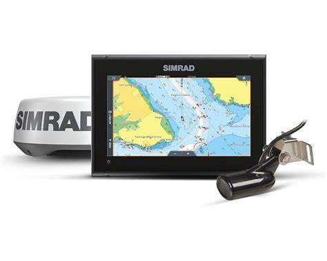
Simrad GO9 XSE Fish Finder/Chartplotter with HDI Transducer, C-MAP DISCOVER Charts, and HALO20 Radar
€1,200.00

Get more from every day on the water with the Simrad® GO9 XSE Fish Finder/Chartplotter with HDI Transducer, C-MAP® DISCOVER™ Charts, and HALO20 Radar. The sunlight-viewable touch screen lets you control a built-in GPS receiver, echosounder, wireless connectivity, powerful fish-finding sonar capabilities, and industry-standard NMEA 2000® networking. C-MAP DISCOVER charts offer ultra-wide coverage in the US and Canada, with full-featured Vector Charts, Custom Depth Shading, Tides & Currents, and the very best of C-MAP high-resolution bathymetric contours, including integrated Genesis® data. Use C-MAP Easy Routing™ to make planning your next trip on the water as easy as planning a trip in the car, and always have the latest DISCOVER chart data with 12 months of free online updates. GO displays are compatible with a wide range of optional charts, including C-MAP, Navionics®, Florida Marine Tracks, CMOR Mapping, StrikeLines and more. A transom-mounted HDI Skimmer® transducer delivers fish-finding sonar and a simple way for powerboating enthusiasts to keep an eye on depth. CHIRP technology enables clear detection of fish throughout the water column, while DownScan Imaging™ sonar creates a picture-like view of fish-holding structure beneath your boat. FishReveal™ technology combines these 2 specialized views into a single, crystal-clear picture of fish and structure. HALO20 radar provides a great way to add pulse compression technology to smaller powerboats. See channel markers from right off the bow to storm cells 24nm. This compact dome radar install easily, has low power draw, and wakes instantly from standby to give you radar coverage exactly when and where you need it. Built-in wireless connectivity mirrors your display to a compatible smartphone or tablet, giving you instant access to charts, radar, and other functionality from anywhere on board. Discover the Simrad difference with the GO9 XSE.
Manufacturer model #: 000-16294-001.
- 9″, high-resolution, sunlight-viewable touch screen
- Built-in GPS receiver, echosounder, wireless connectivity, powerful fish-finding sonar capabilities, and NMEA 2000 networking
- C-MAP DISCOVER charts: outstanding coverage in the US and Canada, with Vector Charts, Custom Depth Shading, Tides & Currents, and bathymetric contours
- C-MAP Easy Routing
- 12 months of DISCOVER free online chart data updates
- Transom-mounted HDI Skimmer transducer
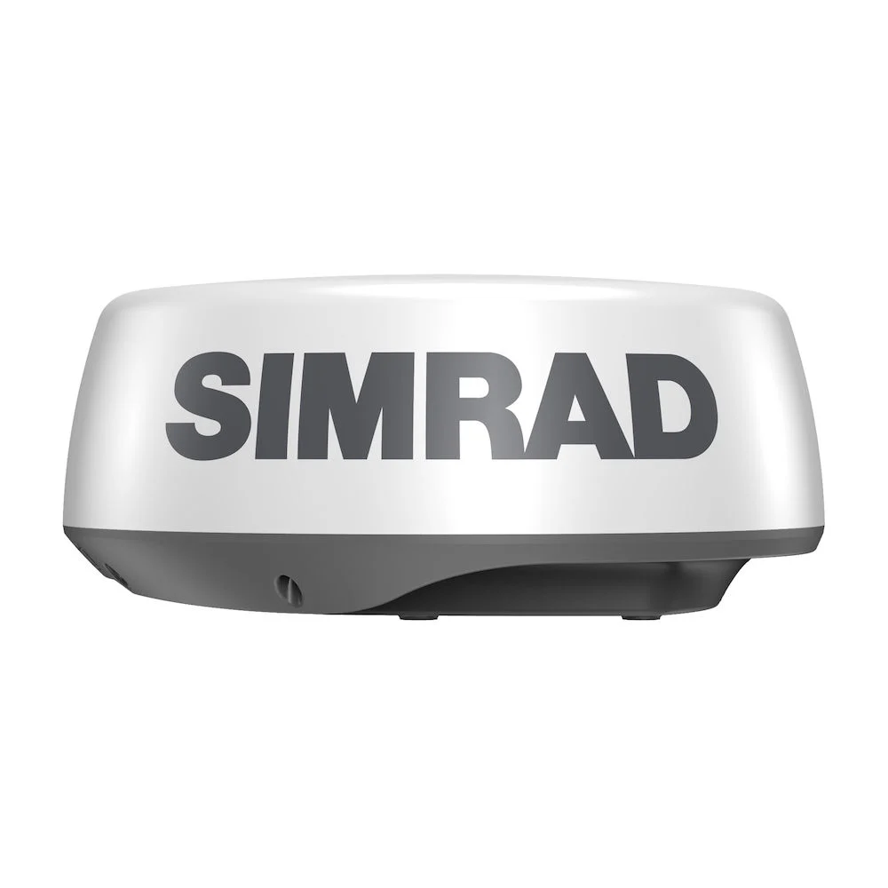
- HALO20 pulse compression radar
- FishReveal: CHIRP and DownScan Imaging on 1 crystal-clear picture
- Built-in wireless connectivity
Specifications
| Transducer Model | 83/200 Skimmer + Halo 20 Radar |
| GPS Included | Yes |
| Model Number | 000-16294-001 |
| Pursuit | Freshwater Fishing |
| Water Resistance | None |
| Waterproof | No |
Description
Simrad GO9 XSE Fish Finder/Chartplotter with HDI Transducer, C-MAP DISCOVER Charts, and HALO20 Radar
Smarter Navigation. Sharper Sonar. Superior Awareness.
Precision on the water changes everything. Confidence follows when navigation, sonar, and radar operate in seamless harmony. The Simrad GO9 XSE Fish Finder/Chartplotter with HDI Transducer, C-MAP DISCOVER Charts, and HALO20 Radar equips anglers and boaters with an integrated marine electronics suite engineered for performance, clarity, and reliability.
Unlike standalone units that limit expansion, this advanced multifunction display (MFD) combines fish-finding intelligence, high-resolution chartplotting, and Doppler-enabled radar awareness into a single streamlined interface. As a result, situational awareness increases while operational complexity decreases. Every feature supports efficiency. Every function prioritizes clarity.
Furthermore, intuitive touchscreen control ensures accessibility for all experience levels. Whether navigating coastal waterways, exploring inland lakes, or running offshore routes, this system empowers every boater to operate with precision and inclusivity.
Why the Simrad GO9 XSE Fish Finder/Chartplotter with HDI Transducer, C-MAP DISCOVER Charts, and HALO20 Radar Stands Out
Modern marine electronics must deliver more than basic sonar readings. Advanced anglers demand detailed structure imaging. Coastal cruisers expect reliable radar detection. Safety-conscious captains require real-time situational data. Therefore, integration becomes essential.
The Simrad GO9 XSE Fish Finder/Chartplotter with HDI Transducer, C-MAP DISCOVER Charts, and HALO20 Radar delivers:
-
High-definition CHIRP sonar and DownScan Imaging™
-
Detailed C-MAP DISCOVER chart coverage
-
HALO20 pulse compression radar with VelocityTrack™
-
9-inch SolarMAX™ sunlight-viewable display
-
Wireless and NMEA 2000® connectivity
-
Expandable networking for future upgrades
Because reliability drives decision-making at sea, Simrad engineered this system to operate consistently across diverse marine environments.
Advanced Sonar Performance with HDI Transducer
See Beneath the Surface with Precision
Clear underwater imaging defines fishing success. The integrated HDI (Hybrid Dual Imaging) transducer supports both CHIRP sonar and DownScan Imaging™, delivering sharp, high-contrast visuals of fish arches, bait schools, and bottom structures.
Traditional sonar transmits single-frequency pulses. However, CHIRP sonar sweeps across multiple frequencies continuously. Consequently, target separation improves dramatically. Fish positioned near structure appear distinctly separated rather than blended into clutter.
Moreover, adaptive frequency output enhances depth penetration while maintaining clarity. Whether fishing shallow flats or probing deeper drop-offs, imaging remains consistent.
CHIRP Sonar Benefits
-
Cleaner fish arch definition
-
Improved bottom detail
-
Reduced signal noise
-
Enhanced depth accuracy
-
Greater confidence in variable water conditions
Because clarity increases reaction speed, anglers can adjust lure placement and boat positioning more effectively.
DownScan Imaging™ for Structural Detail
Structure often determines productivity. Reefs, ledges, submerged timber, and wrecks create fish-holding zones. DownScan Imaging™ uses high-frequency sonar to render near-photographic images of underwater terrain.
As a result, anglers can distinguish rock piles from vegetation. Additionally, bait clouds appear differentiated from predator species. This level of detail reduces guesswork and enhances strategic targeting.
Furthermore, split-screen capability allows simultaneous CHIRP and DownScan viewing. Therefore, you evaluate both fish arches and structural features without switching screens.
Navigate with Confidence Using C-MAP DISCOVER Charts
Detailed Mapping for Coastal and Inland Waters
Navigation requires reliable cartography. Preloaded C-MAP DISCOVER charts provide high-resolution bathymetric contours, vector chart data, and dynamic raster layers.
Depth shading tools allow customization for safer route planning. Consequently, boaters can visually highlight shallow hazards and deeper channels according to vessel draft.
C-MAP DISCOVER Chart Features
-
High-detail coastal and inland coverage
-
Depth shading customization
-
Tidal and current information
-
Marina and harbor data
-
Easy waypoint and route creation
Because route planning efficiency enhances fuel economy and trip timing, integrated chart tools contribute to operational precision.
Intelligent Route Planning and Waypoint Management
Efficient navigation minimizes risk and maximizes enjoyment. The system allows intuitive waypoint marking, route editing, and track logging.
Touch gestures enable pinch-to-zoom scaling, rapid map panning, and direct waypoint placement. As a result, planning becomes intuitive rather than technical.
Moreover, integration with radar overlay ensures that chart data aligns with live radar targets. Therefore, navigational decisions incorporate both static map information and dynamic environmental inputs.
HALO20 Radar: Enhanced Situational Awareness
Instant-On Pulse Compression Technology
Visibility conditions shift quickly on open water. Fog banks develop unexpectedly. Vessel traffic increases near harbor entrances. Weather cells approach without warning.
The HALO20 radar activates instantly from standby mode. Unlike traditional magnetron radar systems, pulse compression technology provides sharper target definition and improved short-range performance.
Radar Capabilities Include:
-
10W solid-state pulse compression
-
Up to 24 nautical mile detection range
-
Dual-range operation
-
MARPA target tracking
-
VelocityTrack™ Doppler alerts
Because real-time awareness improves safety margins, radar functionality supports proactive decision-making.
VelocityTrack™ Doppler Collision Detection
Safety technology must deliver actionable data. VelocityTrack™ highlights approaching vessels using color-coded indicators based on relative motion.
Red indicates potential collision risk. Green signals moving-away targets. Consequently, navigators interpret risk levels instantly.
Additionally, dual-range mode allows simultaneous monitoring of near-field hazards and distant objects. Therefore, captains maintain comprehensive situational awareness.
SolarMAX™ 9-Inch Touchscreen Display
High Visibility in Direct Sunlight
Sun glare reduces readability on inferior displays. The SolarMAX™ screen maintains brightness and contrast even under direct sunlight.
Wide viewing angles ensure visibility from multiple helm positions. Consequently, both captains and crew can monitor data comfortably.
Display Advantages
-
9-inch high-resolution touchscreen
-
Multi-touch gesture control
-
Customizable split-screen layouts
-
Quick-access dashboard menus
Because intuitive design reduces learning curves, users of all skill levels operate confidently.
Seamless Connectivity and System Integration
Expandable Marine Networking
Modern vessels rely on interconnected systems. The Simrad GO9 XSE Fish Finder/Chartplotter with HDI Transducer, C-MAP DISCOVER Charts, and HALO20 Radar supports NMEA 2000® and Ethernet networking.
Engine data, AIS targets, autopilot systems, and additional sonar modules integrate smoothly. As a result, the display becomes a centralized command hub.
Connectivity Highlights
-
Wireless software updates
-
Smartphone and tablet connectivity
-
Autopilot compatibility
-
AIS vessel tracking
-
Engine monitoring integration
Because adaptability extends product lifespan, this system grows alongside evolving vessel configurations.
Built for Reliability in Marine Environments
Rugged Construction for Demanding Conditions
Saltwater exposure, vibration, and temperature swings challenge marine electronics. Nevertheless, this system features marine-grade construction designed for durability.
IPX7 waterproof rating protects internal components against splashes and temporary immersion. Additionally, corrosion-resistant materials enhance longevity.
Consequently, performance remains dependable across seasons.
Who Benefits Most from This System?
Versatility defines the Simrad GO9 XSE Fish Finder/Chartplotter with HDI Transducer, C-MAP DISCOVER Charts, and HALO20 Radar.
Ideal For:
-
Offshore anglers targeting pelagic species
-
Coastal cruisers navigating busy waterways
-
Inland lake fishers mapping structure
-
Tournament competitors seeking sonar precision
-
Small to mid-sized center consoles and bay boats
Because inclusive design supports varying experience levels, both beginners and seasoned captains operate with equal confidence.
Technical Specifications Snapshot
-
Display Size: 9 inches
-
Sonar: CHIRP / DownScan Imaging™ via HDI
-
Radar: HALO20 10W pulse compression
-
Charting: C-MAP DISCOVER included
-
Networking: NMEA 2000®, Ethernet, WiFi
-
Waterproof Rating: IPX7
Deeper Technology. Smarter Decisions. Greater Control.
Performance offshore depends on actionable data. Strategic anglers rely on precision imaging. Safety-focused captains prioritize real-time awareness. Therefore, understanding how each component of the Simrad GO9 XSE Fish Finder/Chartplotter with HDI Transducer, C-MAP DISCOVER Charts, and HALO20 Radar works together unlocks its full potential.
While Part 1 introduced the core capabilities, this section dives deeper into sonar architecture, radar intelligence, installation optimization, competitive positioning, and advanced use scenarios. Consequently, you gain clarity not only about features—but about measurable advantages.
Advanced Sonar Architecture Explained
CHIRP Sonar Signal Processing: Why It Matters
Traditional single-frequency sonar sends a fixed pulse. By contrast, CHIRP (Compressed High-Intensity Radar Pulse) technology transmits across a spectrum of frequencies. As a result, the system receives significantly more return data.
More data improves:
-
Target separation
-
Noise rejection
-
Bottom definition
-
Fish size differentiation
-
Depth accuracy at speed
Because signal compression sharpens echo interpretation, the Simrad GO9 XSE Fish Finder/Chartplotter with HDI Transducer, C-MAP DISCOVER Charts, and HALO20 Radar allows anglers to distinguish closely grouped fish from surrounding structure.
Additionally, adaptive gain control continuously adjusts output based on water conditions. Therefore, clarity remains consistent whether fishing freshwater lakes or saltwater reefs.
DownScan Imaging™ vs. Traditional Sonar
Clarity transforms confidence. Unlike conventional 2D sonar, DownScan Imaging™ produces near-photographic images of underwater terrain.
DownScan Advantages
-
High-frequency structure detail
-
Clear vegetation mapping
-
Improved wreck identification
-
Accurate rock pile recognition
Consequently, anglers interpret structure type instantly. Instead of guessing whether marks represent bait or debris, you identify fish-holding zones precisely.
Furthermore, split-screen configurations allow simultaneous CHIRP and DownScan viewing. Thus, decision-making becomes data-driven rather than speculative.
HALO20 Radar Performance in Real Conditions
Short-Range Precision for Crowded Waterways
Busy marinas demand fast interpretation. Narrow channels require precise obstacle detection. Sudden fog banks reduce visual range dramatically.
The HALO20 radar, integrated within the Simrad GO9 XSE Fish Finder/Chartplotter with HDI Transducer, C-MAP DISCOVER Charts, and HALO20 Radar, excels at short-range clarity.
Real-World Radar Advantages
-
Detect kayaks and small vessels at close range
-
Track multiple targets simultaneously
-
Maintain dual-range views (near + far)
-
Instantly wake from standby mode
Because radar refresh rates remain rapid, moving objects appear smooth and trackable.
Doppler VelocityTrack™ in Action
Collision avoidance technology must be intuitive. VelocityTrack™ simplifies risk detection by color coding targets.
-
Red = approaching vessel
-
Green = departing vessel
-
Neutral = stationary or low-risk
As a result, captains assess collision vectors within seconds. Additionally, MARPA (Mini Automatic Radar Plotting Aid) enables up to 10 tracked targets simultaneously.
Consequently, situational awareness improves dramatically in low-visibility scenarios.
Integrated Chart and Radar Overlay
Layered Intelligence for Safer Navigation
Chart data shows static terrain. Radar displays dynamic movement. Combined overlays merge both.
Therefore, captains interpret shoreline contours, navigation markers, and moving vessels on one unified screen.
Because redundancy enhances safety, this layered interface minimizes misinterpretation.
Installation Best Practices
Mounting for Optimal Visibility
Correct installation ensures maximum usability.
Mounting Options
-
Flush mount for clean helm integration
-
Bracket mount for adjustable viewing angle
-
Overhead radar dome installation for clear line-of-sight
Placement considerations include:
-
Unobstructed radar rotation
-
Minimal vibration zones
-
Easy cable routing
-
Clear helm ergonomics
Proper alignment enhances radar accuracy and sonar clarity.
Electrical and Network Integration
The Simrad GO9 XSE Fish Finder/Chartplotter with HDI Transducer, C-MAP DISCOVER Charts, and HALO20 Radar integrates via:
-
NMEA 2000® backbone
-
Ethernet for radar communication
-
Dedicated fused power supply
Because voltage stability influences sonar performance, clean power connections remain critical.
Additionally, firmware updates via WiFi maintain peak functionality over time.
Competitive Positioning: Why Choose Simrad?
Compared to Garmin and Lowrance
Marine electronics buyers often evaluate competing brands. However, integration depth and radar capability distinguish this system.
Competitive Advantages
-
Instant-on solid-state radar
-
Doppler collision detection
-
Advanced dual-range radar monitoring
-
Highly responsive touchscreen interface
-
Professional-grade sonar processing
Where entry-level units limit expansion, the Simrad GO9 XSE Fish Finder/Chartplotter with HDI Transducer, C-MAP DISCOVER Charts, and HALO20 Radar supports future upgrades.
Therefore, long-term investment value increases.
Use-Case Scenarios for Maximum Conversion Impact
Offshore Fishing Expedition
Early morning departure requires route planning. C-MAP DISCOVER charts outline underwater contours. Waypoints mark previous productive zones.
Upon arrival, CHIRP sonar identifies bait schools suspended at mid-depth. DownScan Imaging™ reveals reef structure below.
Meanwhile, HALO20 radar monitors surrounding vessel traffic.
As a result, anglers fish confidently while maintaining full environmental awareness.
Coastal Cruising in Variable Weather
Unexpected fog develops mid-transit. Visibility drops quickly.
Instant-on radar activates. VelocityTrack™ highlights approaching vessels. Chart overlay confirms safe channel boundaries.
Therefore, stress decreases while safety increases.
Inland Lake Tournament Strategy
Precise depth shading reveals submerged humps. Waypoints organize structure spots.
Because fish often stage near contour transitions, sonar detail becomes decisive.
Consequently, competitive anglers gain tactical advantage.
Extended Technical Overview
Radar Specifications
-
Output: 10W pulse compression
-
Range: Up to 24 nautical miles
-
Beam width: 5.2° horizontal
-
Rotation speed: 24 RPM
-
Waterproof rating: IPX6
Sonar Specifications
-
Frequency support: 50/200 kHz (CHIRP capable)
-
DownScan frequency: 455/800 kHz
-
Maximum depth capability varies by conditions
Conversion-Optimized Benefits Summary
Choosing the Simrad GO9 XSE Fish Finder/Chartplotter with HDI Transducer, C-MAP DISCOVER Charts, and HALO20 Radar delivers:
-
Integrated sonar, radar, and chartplotting
-
Enhanced fish detection accuracy
-
Real-time collision avoidance technology
-
Expandable marine networking
-
Sunlight-readable touchscreen display
-
Reliable performance in demanding environments
Because modern boating demands data clarity, this system provides measurable improvements in navigation efficiency and fishing precision.
Precision Technology Meets Purpose-Driven Performance
Confidence offshore is built, not assumed. Clarity beneath the surface is earned through intelligent sonar processing. Safety during navigation is strengthened by reliable radar awareness. For that reason, the Simrad GO9 XSE Fish Finder/Chartplotter with HDI Transducer, C-MAP DISCOVER Charts, and HALO20 Radar stands as a fully integrated marine command system engineered for anglers, cruisers, and competitive captains alike.
While previous sections detailed sonar, radar, and installation advantages, this segment expands into semantic SEO depth, buyer psychology drivers, advanced feature analysis, and conversion-focused enhancements. Consequently, you gain a comprehensive understanding of why this system delivers measurable value on the water.
The Complete Marine Command Center
Unified Multifunction Control
Marine electronics often operate in silos. However, this integrated solution consolidates sonar, radar, and navigation into a centralized interface powered by the GO-series architecture from Simrad.
Because unified control reduces interface switching, helm efficiency improves immediately. Split-screen layouts allow sonar, chart, and radar views simultaneously. Therefore, decision-making becomes streamlined and situational awareness expands.
Operational Advantages
-
Touchscreen responsiveness comparable to modern tablets
-
Customizable dashboards for fishing or navigation priorities
-
Adjustable sonar color palettes for visibility preference
-
Rapid waypoint marking via touchscreen tap
As a result, time spent configuring settings decreases while time spent fishing or cruising increases.
Deep Dive: C-MAP DISCOVER Chart Intelligence
Precision Mapping Powered by C-MAP
Navigation accuracy depends on high-quality cartography. The preloaded DISCOVER charts originate from C-MAP, recognized globally for hydrographic detail.
Because bathymetric contour density influences route planning precision, detailed depth shading improves hazard awareness.
Mapping Enhancements Include:
-
High-resolution vector data
-
Marina and harbor infrastructure information
-
Customizable safety depth shading
-
Automatic route suggestions
-
Dynamic raster chart overlays
Furthermore, waypoint synchronization simplifies trip logging and return navigation.
Radar Innovation with HALO20
Solid-State Radar Engineering
Traditional magnetron radar systems require warm-up time and generate higher power consumption. In contrast, the HALO20 dome radar leverages solid-state pulse compression from Simrad to deliver immediate readiness.
Because 10W pulse compression improves short-range target resolution, small vessels and floating debris become easier to identify.
Advanced Radar Capabilities
-
Dual-range simultaneous monitoring
-
Instant-on technology
-
MARPA tracking for moving vessels
-
Doppler-based VelocityTrack™ alerts
-
Low electromagnetic emissions
Consequently, navigators gain enhanced control during restricted visibility scenarios.
Buyer Psychology and Conversion Drivers
Why Integrated Marine Electronics Increase Confidence
Boat owners evaluate electronics based on three primary concerns:
-
Safety
-
Fish-finding accuracy
-
Long-term investment value
The Simrad GO9 XSE Fish Finder/Chartplotter with HDI Transducer, C-MAP DISCOVER Charts, and HALO20 Radar addresses each directly.
Safety Benefits
-
Doppler radar collision alerts
-
Chart and radar overlay integration
-
Depth shading hazard visualization
Fishing Performance Benefits
-
CHIRP sonar frequency sweep clarity
-
DownScan Imaging™ structural detail
-
Accurate target separation
Investment Value Benefits
-
Expandable networking
-
Software update capability
-
Durable marine-grade construction
Therefore, the purchase becomes a strategic upgrade rather than a simple electronics addition.
Frequently Asked Questions (FAQ)
Simrad GO9 XSE Fish Finder/Chartplotter with HDI Transducer, C-MAP DISCOVER Charts, and HALO20 Radar
Clear answers improve buying confidence. Detailed explanations reduce post-purchase uncertainty. Therefore, this comprehensive FAQ section addresses technical, operational, installation, and compatibility questions about the Simrad GO9 XSE Fish Finder/Chartplotter with HDI Transducer, C-MAP DISCOVER Charts, and HALO20 Radar.
General Product Questions
What is included in the Simrad GO9 XSE Fish Finder/Chartplotter with HDI Transducer, C-MAP DISCOVER Charts, and HALO20 Radar package?
The standard package includes:
-
GO9 XSE 9-inch multifunction display
-
HDI (Hybrid Dual Imaging) transducer
-
Preloaded C-MAP DISCOVER charts
-
HALO20 radar dome
-
Mounting bracket or flush-mount hardware
-
Power cable
-
Network cables (Ethernet for radar)
-
User documentation
Because the system ships as an integrated solution, major components are ready for installation without additional core hardware purchases.
Who manufactures the GO9 XSE system?
The GO9 XSE series is designed and produced by Simrad, a globally recognized marine electronics brand specializing in navigation, sonar, and radar technologies.
Is this system suitable for beginners?
Yes. Touchscreen navigation, intuitive menu structures, and preset sonar modes make the system accessible to new boaters. At the same time, advanced manual controls support experienced captains seeking granular adjustments.
Sonar & Fish Finder Questions
What sonar technologies are included?
The system includes:
-
CHIRP sonar
-
DownScan Imaging™
-
HDI transducer integration
CHIRP technology transmits across multiple frequencies, improving target separation and depth clarity. DownScan Imaging™ delivers high-frequency structural detail.
How deep can the sonar read?
Maximum depth capability varies based on water salinity, bottom composition, and transducer installation. Under optimal conditions, CHIRP sonar can read several hundred feet effectively. Performance improves with proper mounting and clean water flow across the transducer face.
Can I upgrade to Active Imaging™ or side scanning?
Yes. The GO9 XSE supports additional sonar modules via Ethernet expansion. Therefore, anglers can integrate StructureScan® or Active Imaging™ modules for enhanced side imaging capabilities.
Does the system clearly separate fish from structure?
Yes. CHIRP processing enhances target separation, allowing fish positioned near reefs or wrecks to appear distinctly instead of blending into bottom clutter.
Radar & Navigation Questions
What makes the HALO20 radar different from traditional radar?
The HALO20 radar uses solid-state pulse compression technology instead of magnetron-based transmission. As a result:
-
Warm-up time is eliminated
-
Short-range clarity improves
-
Power consumption decreases
-
Doppler collision alerts become available
What is VelocityTrack™ technology?
VelocityTrack™ uses Doppler processing to identify whether radar targets are approaching or moving away. Color-coded indicators help captains quickly interpret collision risks.
What is the maximum radar range?
The HALO20 radar provides up to 24 nautical miles of detection range under ideal conditions. However, short-range precision remains its primary strength, particularly in crowded waterways.
Can radar overlay appear on navigation charts?
Yes. Radar overlay integrates seamlessly with C-MAP chart data, combining static mapping with live radar targets on one unified screen.
Chartplotter & Mapping Questions
What mapping comes preloaded?
The system includes C-MAP DISCOVER charts developed by C-MAP. These charts provide:
-
Detailed bathymetric contours
-
Marina information
-
Depth shading customization
-
Tidal and current data
Can I add additional charts?
Yes. The GO9 XSE supports compatible microSD chart cards, allowing expanded geographic coverage.
Does the chartplotter support route planning?
Absolutely. Users can create, edit, and save routes directly on the touchscreen. Automatic routing suggestions may be available depending on chart coverage.
Installation & Compatibility Questions
Is professional installation required?
While experienced boat owners can complete installation independently, professional installation ensures optimal radar placement, proper NMEA 2000® networking, and correct transducer alignment.
What networking standards does the system support?
The system supports:
-
NMEA 2000®
-
Ethernet
-
WiFi connectivity
This allows integration with:
-
Autopilot systems
-
AIS receivers
-
Engine data systems
-
Additional sonar modules
Can I connect my smartphone or tablet?
Yes. Built-in WiFi supports software updates and limited mobile device connectivity for system management.
What type of power supply does it require?
The GO9 XSE operates on a standard 12V DC marine electrical system. Clean, fused power connections are recommended for stable performance.
Display & Usability Questions
Is the display readable in direct sunlight?
Yes. The 9-inch SolarMAX™ display is engineered for high brightness and wide viewing angles, maintaining visibility in bright marine conditions.
Can I customize screen layouts?
Yes. Split-screen views allow combinations such as:
-
Sonar + chart
-
Radar + chart
-
Sonar + radar + engine data
Customization improves operational efficiency.
Is the touchscreen responsive in wet conditions?
The capacitive touchscreen performs reliably in marine environments. However, heavy water droplets may require quick screen wiping for optimal responsiveness.
Durability & Maintenance Questions
Is the system waterproof?
The display carries an IPX7 waterproof rating, meaning it withstands splashes and brief immersion.
The HALO20 radar dome features IPX6 protection against powerful water jets.
How should I maintain the system?
Routine maintenance includes:
-
Rinsing with fresh water after saltwater use
-
Inspecting radar dome mounting hardware
-
Checking cable connections seasonally
-
Updating firmware regularly
Proper care extends system lifespan.
Performance & Buying Considerations
Is this system suitable for offshore fishing?
Yes. CHIRP sonar depth penetration, structural imaging, and radar monitoring make the system ideal for offshore environments.
Is this a good choice for coastal cruising?
Absolutely. Integrated radar, detailed charts, and route planning tools enhance safety in variable coastal conditions.
Does this system offer long-term value?
Yes. Expandable networking, radar integration, and software update capability position the Simrad GO9 XSE Fish Finder/Chartplotter with HDI Transducer, C-MAP DISCOVER Charts, and HALO20 Radar as a scalable investment rather than a short-term solution.
Additional information
| Transducer Model: | 83-200 Skimmer + Halo 20 Radar |
|---|---|
| GPS Included: | Yes |
Related products
-

Garmin GPSMAP Touch Screen Fish Finder/Chartplotter Combo
Price range: €1,000.00 through €2,168.00Select options This product has multiple variants. The options may be chosen on the product page -
-
Garmin STRIKER Vivid 7 Series Fish Finder
€340.00Select options This product has multiple variants. The options may be chosen on the product page -
Humminbird HELIX 7 CHIRP MEGA SI GPS G4N Fish Finder/Chartplotter
Price range: €500.00 through €700.00Select options This product has multiple variants. The options may be chosen on the product page
Reviews
There are no reviews yet.