Shop

  • Garmin ECHOMAP Ultra 2 Fish Finder

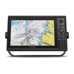
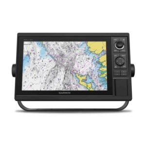
    Garmin ECHOMAP Ultra 2 Fish Finder/Chartplotter 166sv with GT56UHD-TM Transducer

    3,570.00

    Brand Logo

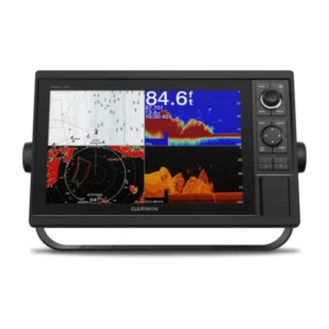
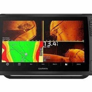
    Designed with the serious angler in mind, the Garmin® ECHOMAP™ Ultra 2 16″ Fish Finder/Chartplotter 166sv with GT56UHD-TM Transducer brings the ultimate in big-picture clarity, brightness, and readability to your navigation mapping and sonar returns. Plus, there’s support for the full line of LiveScope™ sonars (LiveScope transducer not included), and the included GT56UHD transducer gives you Ultra High-Definition ClearVü™ and SideVü™ scanning sonars photo-like images of what’s beneath the surface, as well as CHIRP traditional sonar. Built-in Garmin Navionics+ mapping gives you detailed mapping data, depth range shading, and more, with a 1-year subscription for daily updates. The integrated HDMI output connector lets you share your sonar screen with a TV or other external display. Built-in Bluetooth® wireless connectivity enables you to give voice commands to your chartplotter for hands-free control of such features as Force® trolling motor modes, favorite keys, sonar inputs, and more. Vivid, high-contrast scanning-sonar color palettes make it easier than ever to distinguish targets and structure. Wireless networking lets you share sonar, waypoints and routes with another ECHOMAP Ultra 2 or UHD2 plotter on board. Multi-band GPS provides incredible position accuracy. NMEA 2000® network compatibility gives you connectivity to heading sensors, autopilots, Fusion-Link™ audio systems, and more. Pair with the free ActiveCaptain® smart-device app for software updates, screen recording, Garmin Quickdraw™ Community, data and more. Wirelessly connect to your Force trolling motor (not included) to navigate to waypoints, draw and follow routes, and more. Use the screen-recording feature through the ActiveCaptain app on your smartphone to share images from your chartplotter. Surface-mount your compatible ECHOMAP Ultra 2 chartplotter by using the bail mount with knobs; the mount tilts for optimum viewing. It’s the high-powered sonar upgrade to step your boating and angling forever.

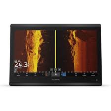
    • Incredibly crisp, hi-res, sunlight-readable 16″ display
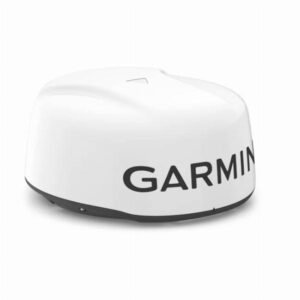
    • Support for full line of LiveScope sonars (LiveScope transducer not included)
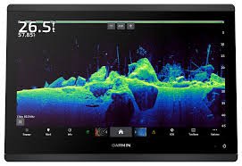
    • Included GT56UHD transducer gives you Ultra High-Definition ClearVü and SideVü scanning sonars and CHIRP traditional sonar
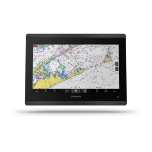
    • Built-in Garmin Navionics+ mapping: detailed mapping data, depth range shading, and more, with a 1-year subscription for daily updates
    • Integrated HDMI output
    • Built-in Bluetooth wireless connectivity: voice commands to your chartplotter for hands-free control
    • Vivid, high-contrast scanning-sonar color palettes
    • Wireless networking to share sonar, waypoints, and routes with another onboard ECHOMAP Ultra 2 or UHD2 chartplotter
    • Multi-band GPS for pinpoint position accuracy
    • NMEA 2000 connectivity to heading sensors, autopilots, Fusion-Link audio systems, and more
    • Free ActiveCaptain smart-device app for software updates, screen recording, Garmin Quickdraw Community data, and more
    • Wirelessly connect to your Force trolling motor (not included) to navigate to waypoints, draw and follow routes, and more
    • Screen-recording feature through ActiveCaptain app to share images from chartplotter
    Garmin ECHOMAP Ultra 2 16” Fish Finder/Chartplotter 166sv with GT56UHD-TM Transducer
    GPS Included Yes
    Model Number 010-03386-01
    Pursuit Freshwater Fishing
    Water Resistance IPX7
    Select optionsLoading Done This product has multiple variants. The options may be chosen on the product page
  • Garmin GMR 18 xHD3 Radome Dome Radar

    Garmin GMR 18 xHD3 Radome Dome Radar

    1,200.00

    Brand Logo

    See more of what’s out there and gain extra peace of mind with the Garmin® GMR™ 18 xHD3 Radome Dome Radar. Combining high-definition imaging with the latest platform technology, this robust 4kW magnetron radar offers new levels of confidence, clarity and performance in a compact 18″ unit for boaters who want to venture out on the water. Scan averaging, a first for Garmin magnetron radar, results in reduced sea clutter and interference on the display. Plus, other advanced features include auto bird gain, improved target-size processing and more. Delivering crisp, high-resolution picture quality and up to a 48-nautical mile detection range, these radars easily connect to your compatible Garmin chartplotter or MFD through the Garmin Marine Network. View a historical echo trail of boats on the water, removing relative motion influence to help you quickly identify moving targets and potential collision threats. Rotation speeds up to 60 rpm improve the redraw rate for faster target updates. Set a safety zone and receive an alarm when an object enters the zone. Dual-radar support provides redundancy and allows each display unit to pull data from different sources. Variable range markers and electronic bearing lines allow rapid measurements of distance and bearing to vessels and land. Garmin GMR 18 xHD3 Radome Dome Radar includes 15m power cable, 15m network cable, and mounting hardware kit/template. 20″W x 9.8″L. Weight: 15.43 lbs.

    • 4kW magnetron radar
    • Scan averaging reduces sea clutter and interference
    • Auto bird gain
    • Improved target-size processing
    • 48-nautical mile detection range
    • Connects to your compatible Garmin chartplotter/MFD
    • View a historical echo trail of nearby boats
    • Dual-radar support provides redundancy
  • Garmin GPSMAP 1222 Fish Finder

    Garmin GPSMAP 1222 Fish Finder/Chartplotter

    1,280.00

    Brand Logo

    The Garmin® GPSMAP 1222 Fish Finder/Chartplotter is designed for cruisers, sailors, and sailing racers who need the advanced all-in-1 solution. This Garmin chartplotter sports a large, bright, 12″ display with quick and easy-to-use keypad interface. User-programmable keys and a multifunction control knob let you effortlessly dial in your optimal settings.

    • Bright, 12″, high-resolution display
    • Designed for cruisers, sailors, and sailing racers
    • Keypad interface
    • User-programmable keys
    • Multifunction control knob

    Specifications

    Garmin GPSMAP 1222 Fish Finder/Chartplotter
    Sonar Type 2D/Down Scanning/Side Scanning
    Screen Size 12 inches
    Transducer Model None
    GPS Included Yes
    Product Color Black
    Live Sonar Compatible LiveScope Compatible
    Map/Chart Type None
    Model Number 010-01741-00
    Pursuit Saltwater Fishing
    Select optionsLoading Done This product has multiple variants. The options may be chosen on the product page
  • Garmin GPSMAP 1242xsv 12

    Garmin GPSMAP 1242xsv 12″ Chartplotter with Sonar, Garmin Navionics+ Mapping, and GT52HW-TM Transducer

    1,800.00
    Brand Logo

    Experience an advanced all-in-1 solution with the Garmin® GPSMAP® 1242xsv 12″ Chartplotter with Sonar, Garmin Navionics+ Mapping, and GT52HW-TM Transducer. This powerhouse Garmin chartplotter has a large, bright screen coupled with a keypad interface and multifunction control knob. A GT52-TM transducer gives you Garmin CHIRP sonar along with CHIRP ClearVü™ and CHIRP SideVü™ scanning sonars. There’s also support for Panoptix™ and LiveScope™ live sonars (transducers not included). Preloaded Garmin Navionics+™ coastal charts and inland mapping features Auto Guidance+™ technology. Plus, there’s support for optional Garmin Navionics Vision+™ premium map content. This GPSMAP combo also boasts Quickdraw Contours software and the Quickdraw Community on the Garmin Connect™ online network. Use built-in Wi-Fi® technology to pair with the free ActiveCaptain® smartphone app for access to the OneChart™ feature, smart notifications, Garmin Quickdraw™ Community data, and more. Garmin Marine Network support allows sharing of sonar, maps, user data, radar, IP cameras, and live sonar among multiple units. Plus, there’s NMEA 2000® and NMEA 0183 network connectivity support including autopilots, digital switching, weather, media, VHF, AIS, and other sensors. These units also include integrated ANT® connectivity support for use with compatible quatix® smartwatches, the gWind™ Wireless 2 transducer, GNX™ Wind marine instrument, and remote controls (not included). See RPMs, fuel flow, temperature, trim, and more for up to four of your compatible Mercury® engines by using the SmartCraft® Connect gateway. The Garmin GPSMAP redefines possibilities on the water.

    • 12″ extra-sharp display
    • Large, bright screen with keypad interface and multifunction control knob
    • GT52-TM transducer with Garmin CHIRP sonar and CHIRP ClearVü and SideVü scanning sonars
    • Support for Panoptix and LiveScope live sonars (transducers not included)
    • Quickdraw Contours
    • Built-in Wi-Fi
    • Garmin Connect online network
    • Garmin Marine Network support
    • NMEA 2000 and NMEA 0183 network connectivity support
    • Integrated ANT connectivity
    • SmartCraft Connect gateway data for Mercury engines

    Specifications

    Garmin GPSMAP 1242xsv 12″ Chartplotter with Sonar, Garmin Navionics+ Mapping, and GT52HW-TM Transducer
    Sonar Type 2D/Down Scanning/Side Scanning
    Screen Size 12 inches
    Transducer Model GT52
    GPS Included Yes
    Product Color Black
    Live Sonar Compatible LiveScope Compatible
    Map/Chart Type US Freshwater/Saltwater
    Model Number 010-01741-60
    Pursuit Saltwater Fishing
    Select optionsLoading Done This product has multiple variants. The options may be chosen on the product page
  • Garmin GPSMAP 1242xsv

    Garmin GPSMAP 1242xsv 12″ Chartplotter with Sonar, Garmin Navionics+ Mapping, and GT52HW-TM Transducer

    1,784.00

    Brand Logo

    Experience an advanced all-in-1 solution with the Garmin® GPSMAP® 1242xsv 12″ Chartplotter with Sonar, Garmin Navionics+ Mapping, and GT52HW-TM Transducer. This powerhouse Garmin chartplotter has a large, bright screen coupled with a keypad interface and multifunction control knob. A GT52-TM transducer gives you Garmin CHIRP sonar along with CHIRP ClearVü™ and CHIRP SideVü™ scanning sonars. There’s also support for Panoptix™ and LiveScope™ live sonars (transducers not included). Preloaded Garmin Navionics+™ coastal charts and inland mapping features Auto Guidance+™ technology. Plus, there’s support for optional Garmin Navionics Vision+™ premium map content. This GPSMAP combo also boasts Quickdraw Contours software and the Quickdraw Community on the Garmin Connect™ online network. Use built-in Wi-Fi® technology to pair with the free ActiveCaptain® smartphone app for access to the OneChart™ feature, smart notifications, Garmin Quickdraw™ Community data, and more. Garmin Marine Network support allows sharing of sonar, maps, user data, radar, IP cameras, and live sonar among multiple units. Plus, there’s NMEA 2000® and NMEA 0183 network connectivity support including autopilots, digital switching, weather, media, VHF, AIS, and other sensors. These units also include integrated ANT® connectivity support for use with compatible quatix® smartwatches, the gWind™ Wireless 2 transducer, GNX™ Wind marine instrument, and remote controls (not included). See RPMs, fuel flow, temperature, trim, and more for up to four of your compatible Mercury® engines by using the SmartCraft® Connect gateway. The Garmin GPSMAP redefines possibilities on the water.

    • 12″ extra-sharp display
    • Large, bright screen with keypad interface and multifunction control knob
    • GT52-TM transducer with Garmin CHIRP sonar and CHIRP ClearVü and SideVü scanning sonars
    • Support for Panoptix and LiveScope live sonars (transducers not included)
    • Quickdraw Contours
    • Built-in Wi-Fi
    • Garmin Connect online network
    • Garmin Marine Network support
    • NMEA 2000 and NMEA 0183 network connectivity support
    • Integrated ANT connectivity
    • SmartCraft Connect gateway data for Mercury engines

    Specifications

    Garmin GPSMAP 1242xsv 12″ Chartplotter with Sonar, Garmin Navionics+ Mapping, and GT52HW-TM Transducer
    Sonar Type 2D/Down Scanning/Side Scanning
    Screen Size 12 inches
    Transducer Model GT52
    GPS Included Yes
    Product Color Black
    Live Sonar Compatible LiveScope Compatible
    Map/Chart Type US Freshwater/Saltwater
    Model Number 010-01741-60
    Pursuit Saltwater Fishing
    Select optionsLoading Done This product has multiple variants. The options may be chosen on the product page
  • Garmin GPSMAP 1643xsv

    Garmin GPSMAP 1643xsv 16″ Chartplotter with Sonar and Garmin Navionics+ Mapping

    3,800.00

    Brand Logo

    With its sleek design, powerful processing, and upgraded IPS display, the Garmin® GPSMAP® 1643xsv 16″ Chartplotter with Sonar and Garmin Navionics+™ Mapping integrates seamlessly into your Garmin marine system. This powerhouse Garmin chartplotter brings built-in Ultra High-Definition SideVü™ and ClearVü™ scanning sonars with vivid, high-contrast color palettes to help distinguish fish from structure. Pair with Panoptix™ or LiveScope™ easy-to-interpret live sonar (transducer not included) to see all around your boat in real time. The high-resolution 16″ IPS display offers improved sunlight readability and visibility from any angle. Experience unparalleled coverage and detail with built-in Garmin Navionics+ integrated coastal and inland mapping that includes Auto Guidance+™ technology. Get support and integration for your Force trolling motor (not included) to gain complete control while you fish. Sail and navigate with ease with SailAssist™ features. View laylines, race start line guidance, enhanced wind rose, heading and course-over-ground lines, true wind data fields and tide/current/time slider, wind angle, set and drift, wind speed, and more. Use the polar table to see key data, including how fast you should go at a certain wind angle and speed — so you know whether you need to adjust sail trim. If you have multiple compatible Garmin devices on your boat, you can share information among them, such as maps, user data, radar, IP camera video, and more. Connect to compatible autopilots, digital switching, weather, the Fusion audio system, media, VHF, AIS, and more from 1 screen. Built-in Wi-Fi® connectivity pairs with the free all-in-1 mobile ActiveCaptain app for access to the OneChart™ feature, smart notifications, software updates, Helm app, Garmin Quickdraw™ Community data, and more. Integrated ANT® technology lets you connect with some of your favorite devices, such as quatix® marine watches, gWind™ Wireless 2 transducers, GNX™ Wind marine instruments, and wireless remote controls. You can connect your chartplotter to different engines, including select Yamaha® engines, and get engine data right on your display. The OneHelm feature brings together all the operations and capabilities of select third-party devices, such as EmpirBus™ digital switching, on 1 screen. Pair your inReach satellite communicator (not included) to your chartplotter, and type custom messages by using the display’s on-screen keyboard. Access your contact list, or enter an email, inReach address, or phone number. You can also group messages by conversation for a texting-like appearance. The Garmin 1643sxv gives you the most dynamic and easy-to-use multifunction display you’ve ever experienced.
    Manufacturer model #: 010-02919-03.

    • Built-in Ultra High-Definition SideVü and ClearVü scanning sonars
    • Vivid, high-contrast color palettes
    • Compatible with Panoptix or LiveScope live sonar (transducer not included)
    • High-resolution, 16″ IPS display
    • Improved sunlight readability and visibility from any angle
    • Built-in Garmin Navionics+ integrated coastal and inland mapping
    • Auto Guidance+ technology
    • Compatible with Force trolling motor (not included)
    • SailAssist features: view laylines, race start line guidance, enhanced wind rose, heading and course-over-ground lines, and much more
    • Built-in Wi-Fi connectivity
    • Access to mobile ActiveCaptain app for OneChart feature, smart notifications, software updates, Helm app, Garmin Quickdraw Community data, and more
    • Integrated ANT technology to connect with quatix marine watches, gWind Wireless 2 transducers, GNX Wind marine instruments, and wireless remote controls
    • Compatible with select engines for onscreen engine data
    • OneHelm feature to display operations and capabilities of select third-party devices on 1 screen
    • Compatible with inReach satellite communicator (not included) for easy onscreen messaging

    Specifications

    Garmin GPSMAP 1643xsv 16″ Chartplotter with Sonar and Garmin Navionics+ Mapping
    GPS Included Yes
    Model Number 010-02919-03
    Pursuit Freshwater Fishing
    Select optionsLoading Done This product has multiple variants. The options may be chosen on the product page
  • Garmin GPSMAP 8612

    Garmin GPSMAP 8612 12” Chartplotter with Garmin Navionics+ Mapping

    2,715.00

    The Garmin® GPSMAP® 8612 12″ Chartplotter with Garmin Navionics+™ Mapping elevates your boating and your expectations. This Garmin multifunction display serves up a 12″ full HD touch-screen display with in-plane switching for wider viewing angles, superior clarity, and sunlight readability, even with polarized sunglasses. It offers built-in support for industry-leading sonar, including dual-channel 1kW traditional CHIRP, CHIRP ClearVü™ and CHIRP SideVü™ scanning sonars, and built-in support for Ultra High-Definition scanning sonar with no black box required. It also supports the LiveScope™ System and the entire live sonar product line, which allow you to clearly see fish swimming around and below your boat in real time (transducers not included). The Garmin 8612 MFD also comes preloaded with Garmin Navionics+ coastal charts and inland mapping with Auto Guidance+™ technology. Plus, there’s support for optional Garmin Navionics Vision+™ premium map content. Experience superior connectivity and networking solutions with complete control of your entire system right at your fingertips. The chartplotter includes a premium-performance processor for Garmin’s fastest map drawing, superior networking, video distribution, and more. Multiple displays can flat-mount edge to edge to create a sleek glass helm look or mounted flush. NMEA 2000® networking and the Garmin Marine Network let you build your full marine electronics suite, from radar and autopilots to cameras and instruments, all controlled from your chartplotter and shared across multiple screens. With SmartMode™ station controls, everything is designed to give you quick, 1-touch access to the information you need to ease high-stress situations such as docking. For full control of your boat on your chartplotter screen, use OneHelm™ to connect to many compatible third-party devices. Built-in Garmin SailAssist™ features provide data, displays, and prerace guidance to gain a competitive edge. Download the ActiveCaptain® app to your smartphone or tablet to manage your marine experience from anywhere, from trip planning and prefishing to purchasing, downloading, and updating maps. See RPMs, fuel flow, temperature, trim and more for up to four of your compatible Mercury® engines by using the SmartCraft® Connect gateway. The GPSMAP 8612 redefines possibilities on the water.

    • 12″ full HD touch-screen display
    • Wider viewing angles, superior clarity, and sunlight readability
    • Compatible with LiveScope live sonar (transducer not included)
    • Preloaded with Garmin Navionics+ coastal charts and inland mapping
    • Auto Guidance+ technology
    • Support for optional Garmin Navionics Vision+ premium map content
    • Premium-performance processor
    • NMEA 2000 networking
    • Garmin Marine Network
    • SmartMode 1-touch access to information and controls
    • OneHelm third-party device connectivity
    • SailAssist sailing enhancements
    • SmartCraft Connect gateway for Mercury engine data

    Specifications

    Garmin GPSMAP 8612 12” Chartplotter with Garmin Navionics+ Mapping
    Sonar Type 2D/Down Scanning/Side Scanning
    Screen Size 12 inches
    Transducer Model None
    GPS Included Yes
    Product Color Black
    Live Sonar Compatible LiveScope Compatible
    Map/Chart Type US Freshwater/Saltwater
    Model Number 010-02092-50
    Pursuit Saltwater Fishing
    Select optionsLoading Done This product has multiple variants. The options may be chosen on the product page
  • Garmin GPSMAP 8616xsv

    Garmin GPSMAP 8616xsv 16″ Chartplotter with Sonar and Garmin Navionics+ Mapping

    4,800.00

    Brand Logo

    The Garmin® GPSMAP® 8616xsv 16″ Chartplotter with Sonar and Garmind Navionics+™ Mapping elevates your boating and your expectations. This Garmin multifunction display serves up a 16″ full HD touch-screen display with in-plane switching for wider viewing angles, superior clarity, and sunlight readability, even with polarized sunglasses. It offers built-in dual-channel 1kW traditional CHIRP, CHIRP ClearVü™ and CHIRP SideVü™ scanning sonars, and built-in support for Ultra High-Definition scanning sonar with no black box required. It also supports the LiveScope™ System and the entire live sonar product line, which allow you to clearly see fish swimming around and below your boat in real time (transducers not included). The Garmin 8616 MFD also comes preloaded with Garmin Navionics+ coastal charts and inland mapping with Auto Guidance+™ technology. Plus, there’s support for optional Garmin Navionics Vision+™ premium map content. Experience superior connectivity and networking solutions with complete control of your entire system right at your fingertips. The chartplotter includes a premium-performance processor for Garmin’s fastest map drawing, superior networking, video distribution, and more. Multiple displays can flat-mount edge-to-edge to create a sleek glass helm look or mounted flush. NMEA 2000® networking and the Garmin Marine Network let you build your full marine electronics suite, from radar and autopilots to cameras and instruments, all controlled from your chartplotter and shared across multiple screens. With SmartMode™ station controls, everything is designed to give you quick, 1-touch access to the information you need to ease high-stress situations such as docking. For full control of your boat on your chartplotter screen, use OneHelm™ to connect to many compatible third-party devices. Built-in Garmin SailAssist™ features provide data, displays, and prerace guidance to gain a competitive edge. Download the ActiveCaptain® app to your smartphone or tablet to manage your marine experience from anywhere, from trip planning and prefishing to purchasing, downloading, and updating maps. See RPMs, fuel flow, temperature, trim and more for up to four of your compatible Mercury® engines by using the SmartCraft® Connect gateway. The GPSMAP 8616 redefines possibilities on the water.

    • 16″ full HD touch-screen display
    • Wider viewing angles, superior clarity, and sunlight readability
    • Built-in dual-channel 1kW traditional CHIRP sonar and CHIRP ClearVü™ and SideVü™ scanning sonars
    • Built-in support for Ultra High-Definition scanning sonar with no black box required
    • Compatible with LiveScope live sonar (transducer not included)
    • Preloaded with Garmin Navionics+ coastal charts and inland mapping
    • Auto Guidance+ technology
    • Support for optional Garmin Navionics Vision+™ premium map content
    • Premium-performance processor
    • NMEA 2000 networking
    • Garmin Marine Network
    • SmartMode 1-touch access to information and controls
    • OneHelm third-party device connectivity
    • SailAssist sailing enhancements
    • SmartCraft Connect gateway for Mercury engine data

    Specifications

    Garmin GPSMAP 8616xsv 16″ Chartplotter with Sonar and Garmin Navionics+ Mapping
    Sonar Type 2D/Down Scanning/Side Scanning
    Screen Size 16 inches
    Transducer Model None
    GPS Included Yes
    Product Color Black
    Live Sonar Compatible LiveScope Compatible
    Map/Chart Type US Freshwater/Saltwater
    Model Number 010-02093-51
    Pursuit Saltwater Fishing
    Select optionsLoading Done This product has multiple variants. The options may be chosen on the product page
  • Garmin GPSMAP Touch Screen

    Garmin GPSMAP Touch Screen Fish Finder/Chart Plotter Combo with Mapping and Sonar

    Price range: €2,000.00 through €3,075.00
    Brand Logo

    Easily powerful. Powerfully easy. The Garmin® GPSMAP® Touch-Screen Fish Finder/Chart Plotter Combo with Mapping and Sonar offers superior clarity and fish-finding power with intuitive controls for total command of your boating and angling. The full HD IPS display offers wider viewing angles, outstanding clarity, and sunlight readability, even with polarized sunglasses. Built-in support for 1kW Dual-Channel CHIRP traditional sonar provides superior target separation, while ClearVü and SideVü scanning sonars let you see up to 1,000′ below and around your boat at 260kHz (transducers not included). Pair your chartplotter with Garmin live sonar support to see all around your boat in real time. Gamin SailAssist™ lets you view laylines, race start line guidance, enhanced wind rose, heading and course-over-ground lines, true wind data fields, and tide/current/time slider, wind angle, set and drift, wind speed, polars, and more. Experience unparalleled coverage and detail with built-in Garmin Navionics+™ integrated coastal and inland mapping that includes Auto Guidance+™ technology and a 1-year subscription for downloadable daily updates and more on select chartplotters. Use the polar table to see key data, including how fast you should go at a certain wind angle and speed, so you know whether you need to adjust sail trim. If you have multiple compatible Garmin devices on your boat, you can share information among them, such as maps, user data, radar, and IP cameras. NMEA 2000® and NMEA 0183 network support lets you connect to autopilots, digital switching, weather, FUSION-Link™ audio system, media, VHF, AIS, and more from a single screen. Built-in Wi-Fi® connectivity pairs with the free all-in-1 ActiveCaptain™ mobile app for access to the OneChart™ feature, smart notifications , software updates, Helm, Garmin Quickdraw™ Community data, and more. Integrated Bluetooth® and ANT wireless technologies connect with some of your favorite devices, such as quatix® marine watches, gWind™ Wireless 2 transducers, GNX™ Wind marine instruments, and wireless remote controls. The OneHelm™ feature brings together all the operations and capabilities of third-party devices, such as EmpirBus™ digital switching, on 1 screen. SmartMode™ controls give you quick, 1-touch access to the information you need to ease high-stress situations such as docking. You can incorporate networked sonar, radar, cameras, media, and more. By networking select Garmin chartplotters with a Force® trolling motor and your compatible Power-Pole® shallow-water anchoring system, you can access advanced boat control features from your plotter, including smart anchor auto-deployment, smart anchor jog, auto stow, anchor drag detection and auto guidance end-of-route anchoring. Spend more time fishing, less time positioning. The Garmin GPSMAP Touch-Screen Fish Finder/Chartplotter Combo checks every box and gives you more power than you ever imagined to take your time on the water to the next level.

    • Full HD IPS display with exceptional viewing angles, clarity, and sunlight readability
    • Built-in support for 1kW Dual-Channel CHIRP traditional sonar and ClearVü and SideVü scanning sonars (transducers not included)
    • SailAssist sailboat-focused feature suite
    • Garmin Navionics+ integrated coastal and inland mapping
    • Auto Guidance+ technology
    • 1-year subscription for downloadable daily updates
    • NMEA 2000 and NMEA 0183 network support
    • Built-in Wi-Fi
    • Access to all-in-1 ActiveCaptain mobile app
    • Integrated Bluetooth and ANT wireless technologies
    • OneHelm third-party device integration
    • SmartMode 1-touch information access
    • Power-Pole shallow-water anchoring system compatibility
    Select optionsLoading Done This product has multiple variants. The options may be chosen on the product page